Marilyn · Perthshire
Beinn Ghlas
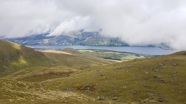
This Beinn Ghlas (not the Lawers Munro of the same name) is a 551m hill above Glen Lochy west of Tyndrum, at NN 131 180. Its grey-green slopes drop into the Allt Cailliche, and the West Highland Railway curves around its foot. The summit looks down on Auch and across to the Beinn Dorain group.
Gaelic: “mountain, grey-green” · Pronunciation: bine glass
Quick facts
- Height
- 551.2m/ 1808ft
- Prominence
- 256 m
- Grid ref
- NN 13158 18076
- Nearest city
- Oban· 30km
- Dogs
- Dogs on lead required near livestockDog-friendly guide ↗
Height and prominence cross-checked against the Database of British and Irish Hills (CC BY).
No GPX track yet
Walked this route? Share your track to help other walkers.
Standard route
heather moorland 65% · grass slopes 25% · rocky summit 10%
Park near Auch Lodge on the A82 at Auchtertyre. Walk up the private track into upper Glen Coralan, then cross the Allt Kinglass and climb the grassy south-east ridge of Beinn Ghlas onto its wide summit plateau. Cairn is a small heap on the highest grass dome.
Terrain
Hard estate track, then short grass and rush above the burn. The summit plateau is a mat of short heather and bilberry on schist. Wet ground only in a few obvious flushes.
In winter
A western hill with mostly damp snow at this elevation; the plateau collects spindrift drifts in cold easterlies. The main winter task is staying on the right ridgeline in cloud — a featureless plateau in poor visibility.
Best time of year
Getting there
- Glasgow2h 19m
- Edinburgh5h 50m
OS maps: OS Landranger 50, OS Landranger 56, OS Explorer 360N
Mobile signal: Expect little. Remote Perthshire; only patchy coverage here.
Current conditions
Daylight Today
- Sunrise
- 05:18
- Sunset
- 21:35
- Civil dawn
- 04:28
- Civil dusk
- 22:25
NOAA Solar Calculator · 30 July 2026
Around Beinn Ghlas on the SCOT network
Getting there, basing yourself, and what to do off the hill.
Getting there: Loch Awe station
East shore Loch Awe; Ben Cruachan; Kilchurn Castle
9km from the hill
tripscot.co.uk
On TripSCOTBase yourself in Oban
Argyll ferry hub — Mull, Lismore, Coll, Tiree, Barra
30km from the hill
tripscot.co.uk
On TasteSCOTAfter the hill: Oban
Oban town centre — tiny two-still distillery bridging Highland and West Coast styles
30km from the hill
tastescot.co.uk
Beinn Ghlas — common questions
- What difficulty is Beinn Ghlas?
- On the OutdoorSCOT scale, Beinn Ghlas comes in at 2/5 — moderate. Underfoot: Hard estate track, then short grass and rush above the burn.
- What is Beinn Ghlas's prominence?
- 256m of prominence. That's the vertical drop from the summit to the col that links Beinn Ghlas to the next higher ground. That drop is what qualifies it as a Marilyn — a hill with at least 150m of descent on every side.
- When is the best time to climb Beinn Ghlas?
- March, April, May, June, July, August, September, October give the most reliable conditions on Beinn Ghlas. Beyond that window the high ground turns wintry: carry full mountain kit, be confident navigating, and check the SAIS avalanche forecast for the area.
- Is Beinn Ghlas dog-friendly?
- Yes, but dogs must be kept on a lead — there is livestock or ground-nesting bird interest on the route.
- Is there mobile signal on Beinn Ghlas?
- Expect little. Remote Perthshire; only patchy coverage here.
- Is Beinn Ghlas safe in winter?
- A western hill with mostly damp snow at this elevation; the plateau collects spindrift drifts in cold easterlies. The main winter task is staying on the right ridgeline in cloud — a featureless plateau in poor visibility.
Get the OutdoorSCOT weekly
One email a week — new route, hill and bothy guides, seasonal conditions and the odd hard-won lesson. No spam, unsubscribe in one click.