Graham · Central Highlands
Carn na h-Easgainn
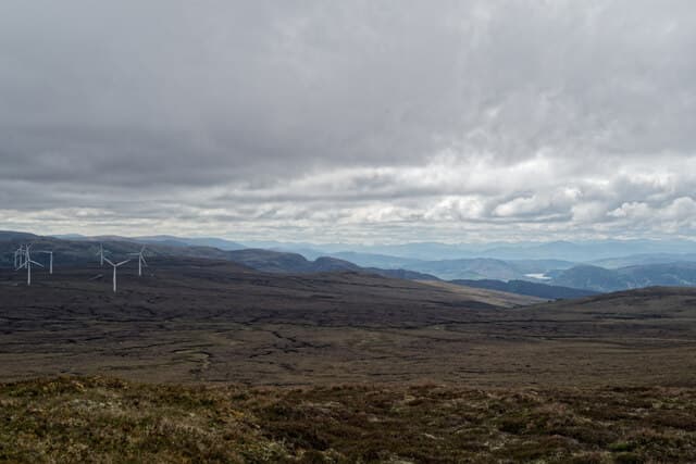
Carn na h-Easgainn (617m), the eel cairn, is a broad heathery dome on the moorland east of Inverness, in the NH74 square. The summit is essentially unmarked save for a small mound of stones, and the appeal is the immense view across the Moray Firth, the Black Isle and the eastern Cairngorms. It is one of the closest Grahams to Inverness and a popular evening walk for locals in summer.
Quick facts
- Height
- 617.2m/ 2025ft
- Prominence
- 173 m
- Distance
- 12 km
- Ascent
- 463 m
- Time
- 3–5 hrs
- Grid ref
- NH743320
- Parking
- NH710276
- Nearest city
- Inverness· 15km
- Dogs
- Dogs on lead required near livestockDog-friendly guide ↗
Height and prominence cross-checked against the Database of British and Irish Hills (CC BY).
No GPX track yet
Walked this route? Share your track to help other walkers.
Standard route
heather moorland 65% · grass slopes 25% · rocky summit 10%
From the parking area at NH710276 near Daviot, take the estate track north onto Drumossie Muir, then climb the long heather ridge east to the highest ground. The going is firm where managed, soggy in between. The summit is reached after a final stretch on grouse-moor heather. Allow about three and a half hours for the round trip; the descent retraces the track.
Terrain
Managed grouse-moor heather and short tussocks dominate, with peaty channels filling the dips. The estate track is the simplest route in and out. The summit area is wide and featureless — without the cairn it would be hard to identify the highest point.
In winter
Drumossie Muir catches snow showers off the Moray Firth, and the broad summit drifts thickly in lee hollows. Inversions in the Inverness basin can leave the hill above cloud on otherwise grey winter days. The lack of features makes whiteout navigation surprisingly serious for so close-to-town a Graham.
This hill is in the Creag Meagaidh SAIS forecast area. Check SAIS forecasts in winter (December–April).
Best time of year
Getting there
- Glasgow3h 13m
- Edinburgh3h 12m
OS maps: OS Landranger 27
Mobile signal: Good signal on summit — close to Inverness with strong reception on most networks.
Current conditions
Daylight Today
- Sunrise
- 04:38
- Sunset
- 22:06
- Civil dawn
- 03:36
- Civil dusk
- 23:09
NOAA Solar Calculator · 13 July 2026
Around Carn na h-Easgainn on the SCOT network
Getting there, basing yourself, and what to do off the hill.
Getting there: Inverness station
Highland capital — Cairngorms east side, Affric, Far North via bus/car
15km from the hill
tripscot.co.uk
On TripSCOTBase yourself in Inverness
Highland capital — gateway to Cairngorms, Affric, Far North
15km from the hill
tripscot.co.uk
On TasteSCOTAfter the hill: Tomatin
Tomatin — large Highland distillery just off the A9, south of Inverness
5km from the hill
tastescot.co.uk
Carn na h-Easgainn — common questions
- How difficult is Carn na h-Easgainn?
- Carn na h-Easgainn carries a 3/5 (moderately challenging) grade on the OutdoorSCOT scale. Count on about 12km, 463m of ascent and a 3-5 hour day on the standard route. Ground conditions: Managed grouse-moor heather and short tussocks dominate, with peaty channels filling the dips.
- How much drop does Carn na h-Easgainn have?
- The drop is 173m: measured from the summit of Carn na h-Easgainn down to the saddle joining it to higher terrain.
- Where's the parking for Carn na h-Easgainn?
- Park at NH710276. Double-check the grid reference on an OS map first; informal laybys here fill early in high season.
- What's the best month to climb Carn na h-Easgainn?
- Aim for March, April, May, June, July, August, September, October, November on Carn na h-Easgainn. In the remaining months treat it as a winter hill — full kit, solid navigation, and a look at the relevant SAIS avalanche forecast before you go.
- Can dogs go up Carn na h-Easgainn?
- Dogs are fine on a lead. The route passes livestock or ground-nesting bird habitat, so keep them close throughout.
- Will I get phone signal on Carn na h-Easgainn?
- Good signal on summit — close to Inverness with strong reception on most networks.
- Is Carn na h-Easgainn safe in winter?
- Drumossie Muir catches snow showers off the Moray Firth, and the broad summit drifts thickly in lee hollows. Inversions in the Inverness basin can leave the hill above cloud on otherwise grey winter days. The lack of features makes whiteout navigation surprisingly serious for so close-to-town a Graham.
Get the OutdoorSCOT weekly
One email a week — new route, hill and bothy guides, seasonal conditions and the odd hard-won lesson. No spam, unsubscribe in one click.