Graham · Arrochar & Trossachs
Beinn a' Mhanaich
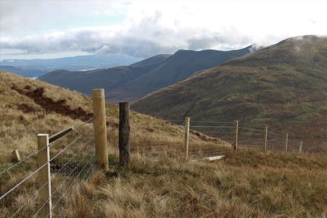
Beinn a' Mhanaich (709m) — the monk's hill — sits at NS26 in the Luss range above Glen Fruin, just north of Beinn Chaorach and east of Loch Long. A grass-and-bilberry cap with a small cairn gives views east over Loch Lomond to Ben Lomond, west to the Cobbler and Beinn Narnain, and south over the Faslane base to the Firth of Clyde. The hill takes its name from an old chapel-of-ease that once stood at the foot of its slopes.
Quick facts
- Height
- 709m/ 2326ft
- Prominence
- 358 m
- Distance
- 13 km
- Ascent
- 581 m
- Time
- 3–6 hrs
- Grid ref
- NS269946
- Parking
- NS275935
- Nearest city
- Glasgow· 44km
- Dogs
- Dogs on lead required near livestockDog-friendly guide ↗
Height and prominence cross-checked against the Database of British and Irish Hills (CC BY).
No GPX track yet
Walked this route? Share your track to help other walkers.
Standard route
heather moorland 60% · grass slopes 30% · summit rocks 10%
From Glen Fruin parking at NS275935, take the metalled estate track climbing north-east into the headwater corrie. Strike up the south-west ridge on sheep paths and short grass to the summit. 13km return for an out-and-back; 581m of climb concentrated in the upper half. The hill makes a natural pairing with Beinn Chaorach for a half-day Luss circuit.
Terrain
Cropped Luss-style turf above 350m gives quick walking. A few peat hags surface on the broad ridge — easily avoided. The summit cairn rests on grassy ground; a small rocky outcrop just below offers shelter from west wind. Lower ground in Glen Fruin can be wet, but estate drainage helps.
In winter
High Loch Long rainfall and frequent freezing-fog episodes coat the bilberry slopes in verglas through any cold snap. Snow lies briefly but rarely deep. The Luss Hills sit outside any formal SAIS region — judgement and patience replace forecast. Daylight here is around eight hours in midwinter — better than central or northern hills.
This hill is in the Southern Highlands SAIS forecast area. Check SAIS forecasts in winter (December–April).
Best time of year
Getting there
- Glasgow1h 2m
- Edinburgh2h 9m
OS maps: OS Landranger 56
Mobile signal: Moderate. EE connects on summit; Vodafone intermittent. Blind spots on the north approach into Glen Fruin.
Current conditions
Daylight Today
- Sunrise
- 04:50
- Sunset
- 22:00
- Civil dawn
- 03:53
- Civil dusk
- 22:57
NOAA Solar Calculator · 13 July 2026
Around Beinn a' Mhanaich on the SCOT network
Getting there, basing yourself, and what to do off the hill.
Getting there: Arrochar & Tarbet station
Arrochar Alps — The Cobbler, Beinn Ime, Beinn Narnain, Ben Vane, Ben Vorlich
11km from the hill
tripscot.co.uk
On TripSCOTBase yourself in Luss
West Loch Lomond village — Highland Boundary, Loch Lomond Way
9km from the hill
tripscot.co.uk
On TasteSCOTAfter the hill: Loch Lomond
Alexandria — sprawling distillery on the south end of the loch
18km from the hill
tastescot.co.uk
Beinn a' Mhanaich — common questions
- How difficult is Beinn a' Mhanaich?
- Beinn a' Mhanaich carries a 3/5 (moderately challenging) grade on the OutdoorSCOT scale. Count on about 13km, 581m of ascent and a 3-6 hour day on the standard route. Underfoot: Cropped Luss-style turf above 350m gives quick walking.
- What is Beinn a' Mhanaich's prominence?
- 358m of prominence. That's the vertical drop from the summit to the col that links Beinn a' Mhanaich to the next higher ground.
- Where do I park for Beinn a' Mhanaich?
- Most walkers start from NS275935. Verify the grid reference on an OS map before you set off — space is tight on busy summer weekends.
- When is the best time to climb Beinn a' Mhanaich?
- April, May, June, July, August, September, October give the most reliable conditions on Beinn a' Mhanaich. Beyond that window the high ground turns wintry: carry full mountain kit, be confident navigating, and check the SAIS avalanche forecast for the area.
- Is Beinn a' Mhanaich dog-friendly?
- Yes, but dogs must be kept on a lead — there is livestock or ground-nesting bird interest on the route.
- Is there mobile signal on Beinn a' Mhanaich?
- Moderate. EE connects on summit; Vodafone intermittent. Blind spots on the north approach into Glen Fruin.
- Is Beinn a' Mhanaich safe in winter?
- High Loch Long rainfall and frequent freezing-fog episodes coat the bilberry slopes in verglas through any cold snap. Snow lies briefly but rarely deep. The Luss Hills sit outside any formal SAIS region — judgement and patience replace forecast. Daylight here is around eight hours in midwinter — better than central or northern hills.
Get the OutdoorSCOT weekly
One email a week — new route, hill and bothy guides, seasonal conditions and the odd hard-won lesson. No spam, unsubscribe in one click.