Corbett · Cairngorms
Mount Battock
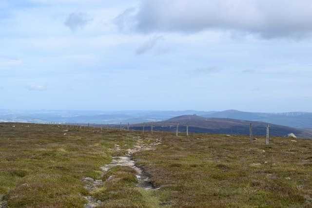
Mount Battock is the easternmost Corbett in Scotland — a broad heather-and-granite hill straddling the boundary between Angus and Aberdeenshire, with its summit at the head of Glen Esk and views east to the North Sea coast. The mountain is the high point of the gentle Mounth plateau and feels more like a Donald hill in character than a typical Highland Corbett: rounded slopes, grass and heather, gentle gradients. The drive in from Edzell up Glen Esk ranks as one of the loveliest in Angus, and the hill makes a good early-season day before the higher peaks shed their snow.
Quick facts
- Height
- 778m/ 2552ft
- Prominence
- 286 m
- Distance
- 19 km
- Ascent
- 700 m
- Time
- 4–7 hrs
- Grid ref
- NO549844
- Parking
- NO448803
- Nearest city
- Aberdeen· 45km
- Dogs
- Dogs on lead required near livestockDog-friendly guide ↗
Height and prominence cross-checked against the Database of British and Irish Hills (CC BY).
No GPX track yet
Walked this route? Share your track to help other walkers.
Standard route
estate road 30% · heather moorland 45% · grassy plateau 15% · summit area 10%
Most parties start from the road end at Millden in Glen Esk, although the route is often combined with a cycle approach to shorten the day on foot. From the road, take the estate track north-west through Glen Mark and on to the Queen's Well — a Victorian monument worth a brief detour. From the well, climb west-north-west onto the open moorland and follow a vague path to the broad summit of Mount Battock. Return reverses the line. Allow 6–7 hours on foot, less if cycling the lower track.
Terrain
Good Land Rover estate track for the first 8km — flat and easy. Beyond the track end, heather and rough grass cover gentle rounded slopes. Drier underfoot than the western Corbetts because of the Cairngorm rain shadow. The summit plateau is featureless; in cloud, navigation needs care.
In winter
Battock ranks as one of the better winter Corbetts for inexperienced winter walkers — gentle gradients, no avalanche-prone steep ground, and easy route-finding in good visibility. Snow lies long on the broad plateau in cold winters. The track can hold ice and drift; cycle wheels become useless once snow is on it. Cold easterlies from the North Sea can be brutal on the summit.
This hill is in the Northern Cairngorms SAIS forecast area. Check SAIS forecasts in winter (December–April).
Best time of year
Getting there
- Glasgow3h 56m
- Edinburgh2h 26m
OS maps: OS Landranger 44
Mobile signal: Reasonable EE/Vodafone in lower Glen Esk; signal weakens past the Queen's Well; usable on the summit looking east
Current conditions
Daylight Today
- Sunrise
- 04:36
- Sunset
- 21:57
- Civil dawn
- 03:35
- Civil dusk
- 22:58
NOAA Solar Calculator · 13 July 2026
Pair with
Curated multi-hill combinations from Mount Battock.
Around Mount Battock on the SCOT network
Getting there, basing yourself, and what to do off the hill.
Getting there: Montrose station
East Angus coast; Montrose Basin nature reserve; Glen Esk approach
32km from the hill
tripscot.co.uk
On TripSCOTBase yourself in Ballater
Eastern Cairngorms / Royal Deeside
21km from the hill
tripscot.co.uk
On TasteSCOTAfter the hill: Royal Lochnagar
Balmoral — Queen Victoria's favourite; eastern Cairngorms setting
28km from the hill
tastescot.co.uk
Mount Battock — common questions
- How difficult is Mount Battock?
- Mount Battock carries a 2/5 (moderate) grade on the OutdoorSCOT scale. Count on about 19km, 700m of ascent and a 4-7 hour day on the standard route. Ground conditions: Good Land Rover estate track for the first 8km — flat and easy.
- How much drop does Mount Battock have?
- The drop is 286m: measured from the summit of Mount Battock down to the saddle joining it to higher terrain.
- Where's the parking for Mount Battock?
- Park at NO448803. Double-check the grid reference on an OS map first; informal laybys here fill early in high season.
- What's the best month to climb Mount Battock?
- Aim for April, May, June, July, August, September, October on Mount Battock. In the remaining months treat it as a winter hill — full kit, solid navigation, and a look at the relevant SAIS avalanche forecast before you go.
- Can dogs go up Mount Battock?
- Dogs are fine on a lead. The route passes livestock or ground-nesting bird habitat, so keep them close throughout.
- Will I get phone signal on Mount Battock?
- Reasonable EE/Vodafone in lower Glen Esk; signal weakens past the Queen's Well; usable on the summit looking east
- Is Mount Battock safe in winter?
- Battock ranks as one of the better winter Corbetts for inexperienced winter walkers — gentle gradients, no avalanche-prone steep ground, and easy route-finding in good visibility. Snow lies long on the broad plateau in cold winters. The track can hold ice and drift; cycle wheels become useless once snow is on it. Cold easterlies from the North Sea can be brutal on the summit.
Get the OutdoorSCOT weekly
One email a week — new route, hill and bothy guides, seasonal conditions and the odd hard-won lesson. No spam, unsubscribe in one click.