Corbett · Cairngorms
Conachcraig
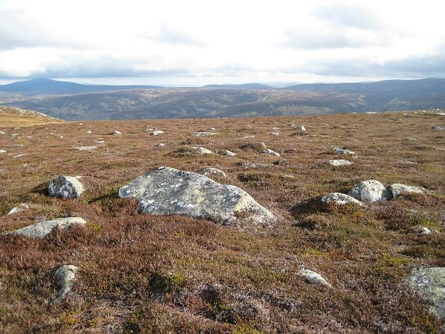
Conachcraig is the rocky outlier on the east side of the Lochnagar massif, looking down Glen Muick from a series of three weathered granite tors. The highest of the tors, at 862m, gives it Corbett status — though by stature it could pass for a small Munro top of Lochnagar were the prominence rules different. The view across Loch Muick to the steep north face of Broad Cairn is one of the great Cairngorm panoramas and a popular reward for parties making the Lochnagar round.
Quick facts
- Height
- 862.5m/ 2830ft
- Prominence
- 185 m
- Distance
- 15 km
- Ascent
- 759 m
- Time
- 5–7 hrs
- Grid ref
- NO279865
- Parking
- NO309851
- Nearest city
- Dundee· 57km
- Dogs
- Dogs on lead required near livestockDog-friendly guide ↗
Height and prominence cross-checked against the Database of British and Irish Hills (CC BY).
No GPX track yet
Walked this route? Share your track to help other walkers.
Standard route
engineered path 30% · heather hillside 35% · granite tors 25% · summit tor 10%
Start from the visitor centre car park at Spittal of Glenmuick at the head of the road from Ballater. Follow the well-built path north along the foot of Conachcraig's west slope, then divert east onto the heather slopes and climb directly to the southernmost tor of Caisteal na Caillich. From there a short ridge leads north over Conachcraig's three tors to the summit. Around 15km with 759m of ascent if combined with Lochnagar via the Cuidhe Crom path.
Terrain
The Lochnagar approach path is one of the best-engineered in the Cairngorms — flagstone-built and well drained. Off the path, the hillside is short heather and granite gravel, slow but never seriously boggy. The summit tors are clean weathered granite; an easy walk-up among the blocks reaches the cairn. No exposure unless you choose to scramble the top of the highest tor itself.
In winter
A more friendly winter Corbett than the Lochnagar plateau next door — the lower altitude and rounded slopes carry less avalanche risk and the granite tors give clear landmarks even in poor visibility. Cornices form along the east edge above Glen Muick in west and south-westerly winds. The Spittal of Glenmuick road is gritted by Balmoral estate and is usually open.
This hill is in the Northern Cairngorms SAIS forecast area. Check SAIS forecasts in winter (December–April).
Best time of year
Getting there
- Glasgow3h 57m
- Edinburgh2h 24m
OS maps: OS Landranger 44
Mobile signal: Good signal near Ballater; 2-3 bars at the cairn plateau above Royal Deeside
Current conditions
Daylight Today
- Sunrise
- 04:38
- Sunset
- 21:59
- Civil dawn
- 03:37
- Civil dusk
- 23:00
NOAA Solar Calculator · 13 July 2026
Pair with
Curated multi-hill combinations from Conachcraig.
Around Conachcraig on the SCOT network
Getting there, basing yourself, and what to do off the hill.
Getting there: Pitlochry station
Schiehallion, Ben Vrackie, Beinn a Ghlo, Edradour distillery
44km from the hill
tripscot.co.uk
On TripSCOTBase yourself in Ballater
Eastern Cairngorms / Royal Deeside
13km from the hill
tripscot.co.uk
On TasteSCOTAfter the hill: Royal Lochnagar
Balmoral — Queen Victoria's favourite; eastern Cairngorms setting
4km from the hill
tastescot.co.uk
Conachcraig — common questions
- How difficult is Conachcraig?
- Conachcraig carries a 3/5 (moderately challenging) grade on the OutdoorSCOT scale. Count on about 15km, 759m of ascent and a 5-7 hour day on the standard route. Underfoot: The Lochnagar approach path is one of the best-engineered in the Cairngorms — flagstone-built and well drained.
- What is Conachcraig's prominence?
- 185m of prominence. That's the vertical drop from the summit to the col that links Conachcraig to the next higher ground.
- Where do I park for Conachcraig?
- Most walkers start from NO309851. Verify the grid reference on an OS map before you set off — space is tight on busy summer weekends.
- When is the best time to climb Conachcraig?
- May, June, July, August, September, October give the most reliable conditions on Conachcraig. Beyond that window the high ground turns wintry: carry full mountain kit, be confident navigating, and check the SAIS avalanche forecast for the area.
- Is Conachcraig dog-friendly?
- Yes, but dogs must be kept on a lead — there is livestock or ground-nesting bird interest on the route.
- Is there mobile signal on Conachcraig?
- Good signal near Ballater; 2-3 bars at the cairn plateau above Royal Deeside
- Is Conachcraig safe in winter?
- A more friendly winter Corbett than the Lochnagar plateau next door — the lower altitude and rounded slopes carry less avalanche risk and the granite tors give clear landmarks even in poor visibility. Cornices form along the east edge above Glen Muick in west and south-westerly winds. The Spittal of Glenmuick road is gritted by Balmoral estate and is usually open.
Get the OutdoorSCOT weekly
One email a week — new route, hill and bothy guides, seasonal conditions and the odd hard-won lesson. No spam, unsubscribe in one click.