Graham · Cairngorms
Hill of Wirren
Hill of Wirren (678m) is a flat-topped Old Red Sandstone landmark on the southern edge of Glen Esk, occupying the NO57 square between Strathmore and the eastern Mounth. The bare summit ground commands one of the great east-coast panoramas — Strathmore, the Sidlaws, the North Sea and the Cairngorm tops all in view from a single rotation.
Quick facts
- Height
- 678m/ 2224ft
- Prominence
- 311 m
- Distance
- 13 km
- Ascent
- 556 m
- Time
- 4–6 hrs
- Grid ref
- NO522739
- Parking
- NO493752
- Nearest city
- Dundee· 45km
- Dogs
- Dogs on lead required near livestockDog-friendly guide ↗
Height and prominence cross-checked against the Database of British and Irish Hills (CC BY).
No GPX track yet
Walked this route? Share your track to help other walkers.
Standard route
heather moorland 65% · grass slopes 25% · rocky summit 10%
Park at Auchmull near the foot of Glen Esk and take the estate track east up the Burn of Berryhill. Once above the woodland, contour onto the broad south-east shoulder and follow a quad rut through ankle-deep heather to the bare summit. A short detour over the east top adds variety; many parties descend by the Burn of Calletar to make a loop.
Terrain
Estate track on the lower slopes followed by managed grouse moor with short heather and quad ruts. The summit is a bare, gravel-strewn plateau with no clear high point — the trig stub and bare patch take some finding. Easy underfoot throughout.
In winter
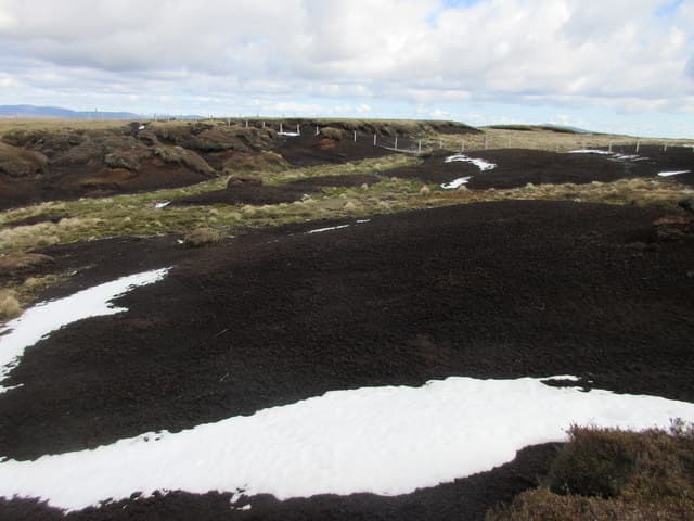
East coast Angus snow lies in patches and gets blown into deep wreaths along the summit lip. The featureless plateau in cloud is the hazard rather than the cold. Wind chill from north-easterlies off the North Sea is exceptional — Hill of Wirren is fully exposed to the haar.
This hill is in the Northern Cairngorms SAIS forecast area. Check SAIS forecasts in winter (December–April).
Best time of year
Getting there
- Glasgow3h 2m
- Edinburgh2h 12m
OS maps: OS Landranger 44
Mobile signal: Signal is good; EE and Vodafone reliable. Prominent Angus hill with clear views.
Current conditions
Daylight Today
- Sunrise
- 04:37
- Sunset
- 21:57
- Civil dawn
- 03:37
- Civil dusk
- 22:57
NOAA Solar Calculator · 13 July 2026
Pair with
Curated multi-hill combinations from Hill of Wirren.
Around Hill of Wirren on the SCOT network
Getting there, basing yourself, and what to do off the hill.
Getting there: Montrose station
East Angus coast; Montrose Basin nature reserve; Glen Esk approach
25km from the hill
tripscot.co.uk
On TripSCOTBase yourself in Ballater
Eastern Cairngorms / Royal Deeside
27km from the hill
tripscot.co.uk
On TasteSCOTAfter the hill: Royal Lochnagar
Balmoral — Queen Victoria's favourite; eastern Cairngorms setting
30km from the hill
tastescot.co.uk
Hill of Wirren — common questions
- Is Hill of Wirren a hard climb?
- Hill of Wirren is rated 4/5 (challenging) on the OutdoorSCOT scale. The standard route covers about 13km with 556m of ascent and takes most walkers 4-6 hours. Terrain: Estate track on the lower slopes followed by managed grouse moor with short heather and quad ruts.
- How prominent is Hill of Wirren?
- Hill of Wirren has 311m of topographic prominence — the height of its summit above the highest col connecting it to higher ground.
- Where should I park to climb Hill of Wirren?
- Standard parking is at NO493752. Check the parking grid reference on an OS map before travel; informal laybys can fill on summer weekends.
- When should I climb Hill of Wirren?
- The standard good-weather months for Hill of Wirren are March, April, May, June, July, August, September, October, November. Outside those months, expect winter conditions on the high ground — full mountain kit, navigation skills, and a check of the SAIS avalanche forecast for the relevant region.
- Can I bring my dog up Hill of Wirren?
- On a lead only — the route crosses ground with livestock or nesting-bird interest.
- What's mobile reception like on Hill of Wirren?
- Signal is good; EE and Vodafone reliable. Prominent Angus hill with clear views.
- Is Hill of Wirren safe in winter?
- East coast Angus snow lies in patches and gets blown into deep wreaths along the summit lip. The featureless plateau in cloud is the hazard rather than the cold. Wind chill from north-easterlies off the North Sea is exceptional — Hill of Wirren is fully exposed to the haar.
Get the OutdoorSCOT weekly
One email a week — new route, hill and bothy guides, seasonal conditions and the odd hard-won lesson. No spam, unsubscribe in one click.