Sub-Marilyn · Glen Coe & Lochaber
Sgorr an Tarmachain
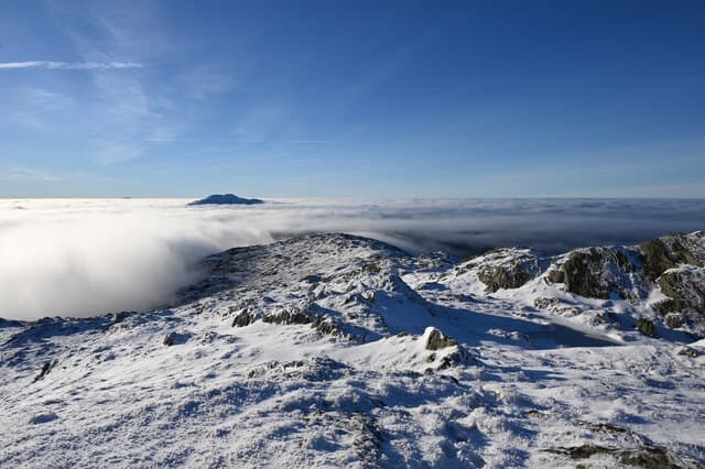
Sgorr an Tarmachain — the Peak of the Ptarmigan — is a 757m rocky summit set well inside Ardgour, often climbed in tandem with neighbouring Druim Garbh. The slim summit cone sits above a broad rough plateau, and ptarmigan are indeed seen here in winter. Views look out to Garbh Bheinn and the long western seaboard.
Quick facts
- Height
- 757.6m/ 2486ft
- Prominence
- 143 m
- Grid ref
- NM 83952 71432
- Nearest city
- Fort William· 27km
- Dogs
- Dogs on lead required near livestockDog-friendly guide ↗
Sub-Marilyn: 143m of drop — misses the 150m Marilyn cut by 7m. We keep it on the list as a near-miss.
Height and prominence cross-checked against the Database of British and Irish Hills (CC BY).
No GPX track yet
Walked this route? Share your track to help other walkers.
Standard route
heather moorland 50% · rocky slopes 35% · grass slopes 15%
Approach from Cona Glen using the estate track, then strike south up steep grass and broken slabs to gain the summit ridge. The final cone is steep but straightforward in summer. Six to seven hours allowing for the long walk in.
Terrain
A long estate track to the foot of the hill, then deep heather and rocky outcrops on the climb. The summit cone has small slabby sections that need careful line choice.
In winter
Holds snow well on its north and east aspects, and the summit cone develops icy patches that ask for crampons. The long walk back from Cona Glen in fading light is the bigger hazard.
This hill is in the Glen Coe SAIS forecast area. Check SAIS forecasts in winter (December–April).
Best time of year
Getting there
- Glasgow4h 6m
- Edinburgh6h 27m
OS maps: OS Landranger 40, OS Explorer 391
Mobile signal: Poor. Remote Moidart peninsula; EE and Vodafone both absent.
Current conditions
Daylight Today
- Sunrise
- 05:18
- Sunset
- 21:40
- Civil dawn
- 04:26
- Civil dusk
- 22:31
NOAA Solar Calculator · 30 July 2026
Around Sgorr an Tarmachain on the SCOT network
Getting there, basing yourself, and what to do off the hill.
Getting there: Glenfinnan station
Glenfinnan Viaduct; Streap, Sgurr Thuilm, Glen Finnan Munros
11km from the hill
tripscot.co.uk
On TripSCOTBase yourself in Fort William
Ben Nevis base, West Highland Line, gateway to Lochaber
27km from the hill
tripscot.co.uk
On TasteSCOTAfter the hill: Ben Nevis Distillery
Fort William — Lochaber distillery at the foot of the Ben; long-aged Japanese-owned classics
29km from the hill
tastescot.co.uk
Sgorr an Tarmachain — common questions
- What difficulty is Sgorr an Tarmachain?
- On the OutdoorSCOT scale, Sgorr an Tarmachain comes in at 2/5 — moderate. Underfoot: A long estate track to the foot of the hill, then deep heather and rocky outcrops on the climb.
- What is Sgorr an Tarmachain's prominence?
- 143m of prominence. That's the vertical drop from the summit to the col that links Sgorr an Tarmachain to the next higher ground. That leaves it 7m short of the 150m drop a Marilyn needs — DoBIH classes it a sub-Marilyn, a near-miss rather than a full Marilyn.
- When is the best time to climb Sgorr an Tarmachain?
- April, May, June, September give the most reliable conditions on Sgorr an Tarmachain. Beyond that window the high ground turns wintry: carry full mountain kit, be confident navigating, and check the SAIS avalanche forecast for the area.
- Is Sgorr an Tarmachain dog-friendly?
- Yes, but dogs must be kept on a lead — there is livestock or ground-nesting bird interest on the route.
- Is there mobile signal on Sgorr an Tarmachain?
- Poor. Remote Moidart peninsula; EE and Vodafone both absent.
- Is Sgorr an Tarmachain safe in winter?
- Holds snow well on its north and east aspects, and the summit cone develops icy patches that ask for crampons. The long walk back from Cona Glen in fading light is the bigger hazard.
Get the OutdoorSCOT weekly
One email a week — new route, hill and bothy guides, seasonal conditions and the odd hard-won lesson. No spam, unsubscribe in one click.