Sub-Marilyn · Skye
Baca Ruadh
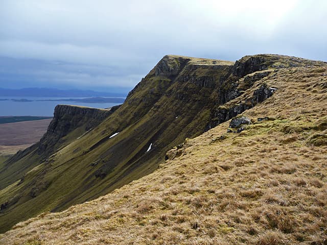
Baca Ruadh is a high point on the Trotternish Ridge of Skye, the long undulating escarpment that runs from the Storr north to the Quiraing. The NG 47 57 grid sits on the main ridge spine, with the eastern flank dropping sheer to Bealach Hartaval and the gentler west side falling to Glen Romesdal.
Gaelic: “red” · Pronunciation: baca roo-ah
Quick facts
- Height
- 638.2m/ 2094ft
- Prominence
- 146 m
- Grid ref
- NG 47489 57546
- Dogs
- Dogs on lead required near livestockDog-friendly guide ↗
Sub-Marilyn: 146m of drop — misses the 150m Marilyn cut by 4m. We keep it on the list as a near-miss.
Height and prominence cross-checked against the Database of British and Irish Hills (CC BY).
No GPX track yet
Walked this route? Share your track to help other walkers.
Standard route
heather moorland 55% · rocky slopes 30% · grass slopes 15%
Approach from the Loch Cuithir track at NG 46 59, then climb the steep grassy west flank to gain the ridge line. From the broad summit plateau the cliff edge demands respect but rewards with views down to the Old Man of Storr. About 10 km return with 580m of climb.
Terrain
Grassy turf on the west, abrupt basalt cliffs on the east — the Trotternish landslip in its most classic form. Care needed near the cornice line as the cliff edge is often hidden by overhanging grass.
In winter
The ridge holds windslab on its eastern leeward side and cornices form readily — these are infamous on Trotternish. In white-out the gentle west slope is forgiving, but straying east is potentially fatal.
Best time of year
Getting there
- Glasgow7h 42m
- Edinburgh9h 51m
OS maps: OS Landranger 23, OS Explorer 408, OS Explorer 409
Mobile signal: Poor. Remote Sutherland or Skye; limited coverage.
Current conditions
Daylight Today
- Sunrise
- 05:16
- Sunset
- 21:47
- Civil dawn
- 04:23
- Civil dusk
- 22:40
NOAA Solar Calculator · 30 July 2026
Around Baca Ruadh on the SCOT network
Getting there, basing yourself, and what to do off the hill.
Getting there: Plockton station
Coastal Wester Ross; Plockton village; Skye Bridge approach
41km from the hill
tripscot.co.uk
On TripSCOTBase yourself in Portree
Main Skye base — Cuillin, Trotternish, Storr
14km from the hill
tripscot.co.uk
On TasteSCOTAfter the hill: Isle of Raasay Distillery
Raasay — new island distillery with rooms; Dun Caan walks from the door
22km from the hill
tastescot.co.uk
Baca Ruadh — common questions
- What difficulty is Baca Ruadh?
- On the OutdoorSCOT scale, Baca Ruadh comes in at 2/5 — moderate. Terrain: Grassy turf on the west, abrupt basalt cliffs on the east — the Trotternish landslip in its most classic form.
- How prominent is Baca Ruadh?
- Baca Ruadh has 146m of topographic prominence — the height of its summit above the highest col connecting it to higher ground. That leaves it 4m short of the 150m drop a Marilyn needs — DoBIH classes it a sub-Marilyn, a near-miss rather than a full Marilyn.
- When should I climb Baca Ruadh?
- The standard good-weather months for Baca Ruadh are March, April, May, June, July, August, September, October. Outside those months, expect winter conditions on the high ground — full mountain kit, navigation skills, and a check of the SAIS avalanche forecast for the relevant region.
- Can I bring my dog up Baca Ruadh?
- On a lead only — the route crosses ground with livestock or nesting-bird interest.
- What's mobile reception like on Baca Ruadh?
- Poor. Remote Sutherland or Skye; limited coverage.
- Is Baca Ruadh safe in winter?
- The ridge holds windslab on its eastern leeward side and cornices form readily — these are infamous on Trotternish. In white-out the gentle west slope is forgiving, but straying east is potentially fatal.
Get the OutdoorSCOT weekly
One email a week — new route, hill and bothy guides, seasonal conditions and the odd hard-won lesson. No spam, unsubscribe in one click.