Long distance
Dava Way
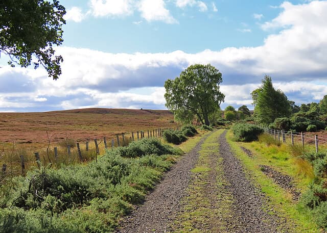
Follows the old Highland Railway line from Forres to Grantown-on-Spey over Dava Moor. Short, gentle and a natural link between the Moray Coast Trail and the Speyside Way. 2 days, 38 km (24 mi), 450 m of cumulative ascent; a waymarked route best tackled best north-to-south — a friendly short trail.
Quick facts
- Distance
- 38 km/ 24 mi
- Typical days
- 2
- Total ascent
- 450 m
- Difficulty
- easy
- Start → Finish
- Forres → Grantown-on-Spey
- Best direction
- North to South
- Water sources
- Forres tap water at start. Streams cross the line in the first 8km (River Divie at Km 8 is reliable). Dava Way Inn at Edinkillie (Km 22) is the last reliable refill before Dava Moor. The moor itself has small burns but they can run dry July–September. Grantown-on-Spey at the finish.
- Mobile signal
- EE/Vodafone coverage at Forres, Edinkillie, Dava and Grantown-on-Spey. No reliable signal on the moorland section from approximately 6km north of Dava through to 4km south of Edinkillie.
✔ Waymarked throughout
Approximate profile derived from per-stage ascent — accurate on total climb and pattern, not a pixel-precise GPX trace.
Our take
The Dava Way is a two-day bridge route that connects the Moray Coast Trail to the Speyside Way — walk all three for a week-long traverse of the northeast. On its own, it is a pleasant moorland walk along a disused railway. Dava Moor has a wild feel despite the gentle gradient. Grantown-on-Spey is a handsome finish town.
Highlights
- Dava Moor — expansive heather moorland
- Old railway viaducts and cuttings
- Views to the Cairngorms
- Grantown-on-Spey arrival
Mid-route waypoints
Navigation by progression marker rather than total distance.
| km | Waypoint | Type |
|---|---|---|
| 0 km | Forres trailhead (Mannachie Road) | start |
| 5 km | Mannachie Forest exitLast shaded section before open farmland | junction |
| 8 km | Bridge over the River Divie | bridge |
| 12 km | Heldon Wood viewpointFirst Cairngorm views | viewpoint |
| 18 km | Divie ViaductStone railway viaduct, 22m high | viaduct |
| 22 km | Edinkillie / Dava Way InnLast refreshments and water before Dava Moor | inn |
| 24 km | Dava station (ruins)Suggested overnight halfway point — no services, wild camp only | station |
| 30 km | Knock of Braemoray crossingHigh point on the moor (~330m) | junction |
| 34 km | Forest edge above Grantown | junction |
| 38 km | Grantown-on-Spey (Strathspey end) | finish |
Day-by-day itinerary
A suggested 2-day schedule. Adjust to your fitness and conditions.
1Forres to Dava20km · 300m ascent
Along the old Highland Railway line from Forres up onto Dava Moor. The landscape changes from farmland to wild open heather moorland.
- Terrain
- Disused railway trackbed, gentle gradient throughout. Moorland.
- Overnight
- Dava has no services. Wild camp on the moor or carry on to Grantown.
- Stats
- Forres → Dava · 20km · ↑300m
2Dava to Grantown-on-Spey18km · 150m ascent
Descend from the moor through forest with Cairngorm views ahead to the handsome planned town of Grantown-on-Spey on the River Spey.
- Terrain
- Disused railway, forest paths, gentle descent.
- Overnight
- Grantown-on-Spey has hotels, B&Bs and the Grant Arms. Connects to the Speyside Way.
- Stats
- Dava → Grantown-on-Spey · 18km · ↑150m
Transport
To start (Forres)
Train · ScotRail
Highland Mainline / Aberdeen–Inverness line to Forres station
Hourly Mon–Sat, every 2 hours Sun. Last train ~22:00.
Forres station is 1km from the trailhead — a 15-minute walk.
Check times & book →Bus · Stagecoach
Service 10 Inverness–Aberdeen calls at Forres
Approximately hourly.
Check times & book →
From finish (Grantown-on-Spey)
Bus · Stagecoach
Service 34 Grantown-on-Spey to Aviemore (for onward Highland Mainline trains)
Roughly every 2 hours Mon–Sat. Limited Sunday service.
Grantown lost its train station in 1968 — bus to Aviemore is the only public-transport route.
Check times & book →Taxi · Local Grantown taxi services
Taxi to Aviemore station (£25–35) for onward train
Useful if you arrive after the last bus or need to be back south the same day.
Best months
Accommodation
Hotels at Forres and Grantown-on-Spey. Nothing in between — carry camping gear or do it as a day walk from either end. Hotels at Forres and Grantown-on-Spey at the trailheads; nothing in the middle. Wild camping on Dava Moor is the standard overnight; the Mountain Bothies Association does not maintain shelters here.
Night-by-night guide: where to stay →Resupply
Shops at Forres and Grantown-on-Spey only. Carry everything for the middle section. Co-op and other shops at Forres and Grantown only; carry everything for the moorland day. The route can be walked in a single long day to avoid a wild camp.
Connect with
Chain into a longer expedition by combining with adjacent long-distance routes.
Dava Way + Moray Coast Trail
Connects at Forres (north end)
Walk the Moray Coast Trail from Findhorn or Cullen into Forres, then continue south on the Dava Way. The Moray Coast adds 50km of coastal walking.
Dava Way + Speyside Way
Connects at Grantown-on-Spey (south end)
The Speyside Way runs north and south from Grantown along the River Spey. Combine the two for a four- or five-day Moray–Strathspey traverse.
Current conditions
Weather at the start point (Forres)
Daylight Today
- Sunrise
- 05:05
- Sunset
- 21:37
- Civil dawn
- 04:12
- Civil dusk
- 22:30
NOAA Solar Calculator · 30 July 2026
Share your experience
Walked the Dava Way? Help others plan their trip.
Getting to and from the Dava Way
Train and town anchors at each end of the route — on TripSCOT.