Munro · Cairngorms
Carn an t-Sagairt Mor
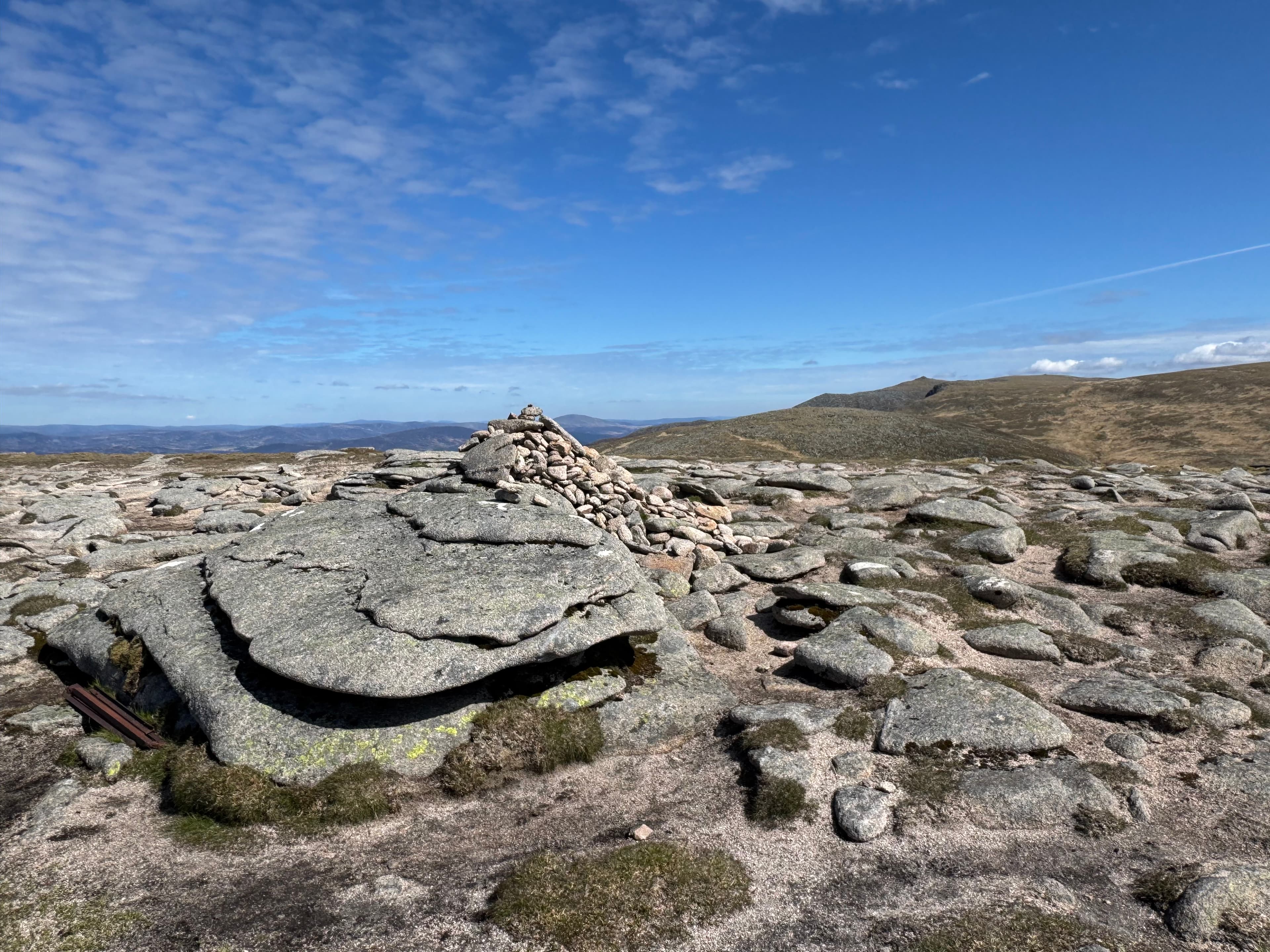
Càrn an t-Sagairt Mòr (1047m) — "the priest's big cairn" — is the Munro immediately west of Lochnagar on the Balmoral side of the Mounth plateau. The summit is famously littered with the scattered wreckage of an RAF Canberra bomber that crashed in 1956 — fragments of fuselage and engine still lie around the cairn. The hill sits on the watershed between the south-flowing Glen Callater and the east-flowing Glen Muick, and is most often included as part of a Lochnagar / White Mounth round.
Gaelic: “cairn-topped hill, the, big” · Pronunciation: karn an t sagairt more
Quick facts
- Height
- 1047m/ 3435ft
- Prominence
- 85 m
- Distance
- 18 km
- Ascent
- 921 m
- Time
- 6–9 hrs
- Grid ref
- NO208842
- Parking
- NO309851
- Nearest city
- Dundee· 57km
- Dogs
- Dogs on lead required near livestockDog-friendly guide ↗
Height and prominence cross-checked against the Database of British and Irish Hills (CC BY).
No GPX track yet
Walked this route? Share your track to help other walkers.
Standard route
Forest / moorland path 35% · Mountain path 35% · Plateau / boulder field 30%
The standard line is from the Spittal of Glenmuick (Glen Muick) car park. Take the well-built path past Loch Muick to the head of the loch, then climb the Streak of Lightning path onto the high White Mounth plateau. From the plateau navigate west-south-west to Càrn an t-Sagairt Mòr; most parties take in Càrn a' Choire Bhoidheach and Lochnagar on the same circuit. Around 21km with 950m of ascent for the round including Lochnagar.
Terrain
The Glen Muick path is excellent — restored stone pitching past the loch. The Streak of Lightning gives a steep ascent on rough scree and grass. The White Mounth plateau is broad open gravel and short alpine vegetation; the route from the top of the lightning path to Sagairt Mòr crosses a confusing flat expanse — careful navigation in cloud essential. The summit area is strewn with aircraft wreckage; treat it as a memorial site.
In winter
A serious winter plateau day in the eastern Cairngorms. The White Mounth plateau is fully exposed to easterly continental winds and routinely sub-arctic. Cornicing along the corrie rims of Coire Loch nan Eun and the south side of Lochnagar is consistent. The Spittal of Glenmuick car park is reliably gritted access. Phone signal absent above the treeline. SAIS Southern Cairngorms applies.
This hill is in the Northern Cairngorms SAIS forecast area. Check SAIS forecasts in winter (December–April).
Best time of year
Getting there
- Glasgow3h 51m
- Edinburgh2h 21m
OS maps: OS Landranger 44
Mobile signal: No dependable signal past the treeline. The nearest car parks have limited signal (Linn of Dee, Braemar, Cairngorm ski area). Carn an t-Sagairt Mor requires offline maps and independent navigation.
Current conditions
Daylight Today
- Sunrise
- 04:55
- Sunset
- 21:45
- Civil dawn
- 04:00
- Civil dusk
- 22:40
NOAA Solar Calculator · 23 July 2026
Around Carn an t-Sagairt Mor on the SCOT network
Getting there, basing yourself, and what to do off the hill.
Getting there: Pitlochry station
Schiehallion, Ben Vrackie, Beinn a Ghlo, Edradour distillery
37km from the hill
tripscot.co.uk
On TripSCOTBase yourself in Ballater
Eastern Cairngorms / Royal Deeside
20km from the hill
tripscot.co.uk
On TasteSCOTAfter the hill: Royal Lochnagar
Balmoral — Queen Victoria's favourite; eastern Cairngorms setting
9km from the hill
tastescot.co.uk
Carn an t-Sagairt Mor — common questions
- How difficult is Carn an t-Sagairt Mor?
- Carn an t-Sagairt Mor carries a 4/5 (challenging) grade on the OutdoorSCOT scale. Count on about 18km, 921m of ascent and a 6-9 hour day on the standard route. Terrain: The Glen Muick path is excellent — restored stone pitching past the loch.
- How prominent is Carn an t-Sagairt Mor?
- Carn an t-Sagairt Mor has 85m of topographic prominence — the height of its summit above the highest col connecting it to higher ground.
- Where should I park to climb Carn an t-Sagairt Mor?
- Standard parking is at NO309851. Check the parking grid reference on an OS map before travel; informal laybys can fill on summer weekends.
- When should I climb Carn an t-Sagairt Mor?
- The standard good-weather months for Carn an t-Sagairt Mor are May, June, July, August, September, October. Outside those months, expect winter conditions on the high ground — full mountain kit, navigation skills, and a check of the SAIS avalanche forecast for the relevant region.
- Can I bring my dog up Carn an t-Sagairt Mor?
- On a lead only — the route crosses ground with livestock or nesting-bird interest.
- What's mobile reception like on Carn an t-Sagairt Mor?
- No dependable signal past the treeline. The nearest car parks have limited signal (Linn of Dee, Braemar, Cairngorm ski area). Carn an t-Sagairt Mor requires offline maps and independent navigation.
- Is Carn an t-Sagairt Mor safe in winter?
- A serious winter plateau day in the eastern Cairngorms. The White Mounth plateau is fully exposed to easterly continental winds and routinely sub-arctic. Cornicing along the corrie rims of Coire Loch nan Eun and the south side of Lochnagar is consistent. The Spittal of Glenmuick car park is reliably gritted access. Phone signal absent above the treeline. SAIS Southern Cairngorms applies.
Get the OutdoorSCOT weekly
One email a week — new route, hill and bothy guides, seasonal conditions and the odd hard-won lesson. No spam, unsubscribe in one click.