Marilyn · Argyll & Bute
Sgarbh Breac
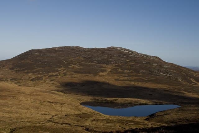
Sgarbh Breac is a 364m Marilyn on the far north of Islay, overlooking the Sound of Islay and Jura. Its position on the Atlantic edge gives it a wilder feel than its modest height suggests.
Quick facts
- Height
- 364m/ 1194ft
- Prominence
- 291 m
- Grid ref
- NR 40630 76620
- Dogs
- Dogs on lead required near livestockDog-friendly guide ↗
Height and prominence cross-checked against the Database of British and Irish Hills (CC BY).
No GPX track yet
Walked this route? Share your track to help other walkers.
Standard route
heather and bog 65% · grass and deer sedge 25% · rocky summit 10%
Approach from Bunnahabhain along the coast then break inland for a steep pull onto the summit ridge. Round trip 3-4 hours; the upper section is trackless.
Terrain
Coastal heather and rocky outcrops near the start give way to higher peaty moor. The summit cairn sits on short turf.
In winter
A solid winter outing — low altitude, short distance and excellent views across to a snow-dusted Jura. Wind is the main consideration.
Best time of year
Getting there
- Glasgow5h 55m
- Edinburgh8h 40m
Ferry access
Kennacraig → Port Askaig or Port Ellen
- Crossing time135 min
- Summer sailings2–3 sailings daily (Apr–Oct)
- Winter sailings1–2 sailings daily (Nov–Mar)
- Book ahead14 days
- Last ferry backCheck CalMac timetable
OS maps: OS Landranger 60, OS Landranger 61, OS Explorer 353E, OS Explorer 354
Mobile signal: Poor. Northern Islay; EE coverage thin away from Port Askaig.
Current conditions
Daylight Today
- Sunrise
- 05:25
- Sunset
- 21:37
- Civil dawn
- 04:36
- Civil dusk
- 22:26
NOAA Solar Calculator · 30 July 2026
Around Sgarbh Breac on the SCOT network
Getting there, basing yourself, and what to do off the hill.
Sgarbh Breac — common questions
- How hard is Sgarbh Breac?
- We grade Sgarbh Breac at 1/5, which puts it in easy territory. Ground conditions: Coastal heather and rocky outcrops near the start give way to higher peaty moor.
- How much drop does Sgarbh Breac have?
- The drop is 291m: measured from the summit of Sgarbh Breac down to the saddle joining it to higher terrain. Passing the 150m-drop threshold on all sides is exactly what makes it a Marilyn.
- What's the best month to climb Sgarbh Breac?
- Aim for March, April, May, June, July, August, September, October on Sgarbh Breac. In the remaining months treat it as a winter hill — full kit, solid navigation, and a look at the relevant SAIS avalanche forecast before you go.
- Can dogs go up Sgarbh Breac?
- Dogs are fine on a lead. The route passes livestock or ground-nesting bird habitat, so keep them close throughout.
- Will I get phone signal on Sgarbh Breac?
- Poor. Northern Islay; EE coverage thin away from Port Askaig.
- How do I get the ferry to Sgarbh Breac?
- Kennacraig → Port Askaig or Port Ellen. 2–3 sailings daily (Apr–Oct) in summer; 1–2 sailings daily (Nov–Mar) in winter. Book at least 14 days ahead.
- Is Sgarbh Breac safe in winter?
- A solid winter outing — low altitude, short distance and excellent views across to a snow-dusted Jura. Wind is the main consideration.
Get the OutdoorSCOT weekly
One email a week — new route, hill and bothy guides, seasonal conditions and the odd hard-won lesson. No spam, unsubscribe in one click.