Marilyn · Argyll
Scrinadle
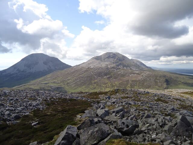
Scrinadle is a 508m Marilyn on central Jura, well to the west of the Paps and overlooking the wild interior. Few walkers reach this remote summit, but those who do enjoy a sense of solitude rarely matched in Scotland.
Quick facts
- Height
- 508m/ 1667ft
- Prominence
- 165 m
- Grid ref
- NR 50525 77798
- Dogs
- Dogs on lead required near livestockDog-friendly guide ↗
Height and prominence cross-checked against the Database of British and Irish Hills (CC BY).
No GPX track yet
Walked this route? Share your track to help other walkers.
Standard route
heather moorland 65% · grass slopes 25% · rocky summit 10%
Access is typically from the A846 between Craighouse and Inverlussa via the long boggy approach. There are no paths and the terrain is uniformly rough. Allow 6-8 hours.
Terrain
Deep tussocks, peat hags and ankle-deep heather throughout. Occasional quartzite ribs give brief respite from the bog. Wet feet are guaranteed.
In winter
Best avoided in winter — short Hebridean daylight combined with featureless ground makes navigation in mist or snow particularly hazardous.
Best time of year
Getting there
- Glasgow5h 31m
- Edinburgh7h 15m
Ferry access
Kennacraig → Port Askaig (Islay) then Port Askaig → Feolin (Jura)
- Crossing time145 min
- Summer sailingsIslay: 1–2 CalMac sailings daily. Jura ferry: frequent throughout the day
- Winter sailingsIslay: 1 CalMac sailing daily. Jura ferry: reduced but regular
- Book ahead21 days
- Last ferry backLast Jura ferry ~17:00; last Islay sailing varies — check both timetables
Two ferries required: CalMac Kennacraig → Port Askaig (2h15), then the short Jura passenger ferry (10 min) from Port Askaig to Feolin. No car needed once on Jura for the Paps.
Book on ferry operator ↗OS maps: OS Landranger 61, OS Explorer 354, OS Explorer 355S
Mobile signal: Minimal. bars vanish on the walk-in; away from Bowmore coverage is thin.
Current conditions
Daylight Today
- Sunrise
- 05:24
- Sunset
- 21:37
- Civil dawn
- 04:35
- Civil dusk
- 22:26
NOAA Solar Calculator · 30 July 2026
Around Scrinadle on the SCOT network
Getting there, basing yourself, and what to do off the hill.
Scrinadle — common questions
- How hard is Scrinadle?
- We grade Scrinadle at 2/5, which puts it in moderate territory. Underfoot: Deep tussocks, peat hags and ankle-deep heather throughout.
- What is Scrinadle's prominence?
- 165m of prominence. That's the vertical drop from the summit to the col that links Scrinadle to the next higher ground. That drop is what qualifies it as a Marilyn — a hill with at least 150m of descent on every side.
- When is the best time to climb Scrinadle?
- March, April, May, June, July, August, September, October give the most reliable conditions on Scrinadle. Beyond that window the high ground turns wintry: carry full mountain kit, be confident navigating, and check the SAIS avalanche forecast for the area.
- Is Scrinadle dog-friendly?
- Yes, but dogs must be kept on a lead — there is livestock or ground-nesting bird interest on the route.
- Is there mobile signal on Scrinadle?
- Minimal. bars vanish on the walk-in; away from Bowmore coverage is thin.
- How do I get the ferry to Scrinadle?
- Kennacraig → Port Askaig (Islay) then Port Askaig → Feolin (Jura). Islay: 1–2 CalMac sailings daily. Jura ferry: frequent throughout the day in summer; Islay: 1 CalMac sailing daily. Jura ferry: reduced but regular in winter. Book at least 21 days ahead. Two ferries required: CalMac Kennacraig → Port Askaig (2h15), then the short Jura passenger ferry (10 min) from Port Askaig to Feolin. No car needed once on Jura for the Paps.
- Is Scrinadle safe in winter?
- Best avoided in winter — short Hebridean daylight combined with featureless ground makes navigation in mist or snow particularly hazardous.
Get the OutdoorSCOT weekly
One email a week — new route, hill and bothy guides, seasonal conditions and the odd hard-won lesson. No spam, unsubscribe in one click.