Marilyn · Argyll
Cnoc an Ime
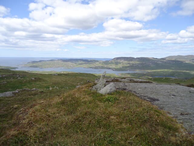
Cnoc an Ime — the Hill of Butter — is a quiet 303m Marilyn in southern Knapdale. The name hints at the rich grazing of these slopes. Sea views to the Sound of Jura crown the modest summit.
Gaelic: “small hill, the, butter” · Pronunciation: k-nok an ime
Quick facts
- Height
- 303m/ 994ft
- Prominence
- 189 m
- Grid ref
- NR 59050 80164
- Dogs
- Dogs on lead required near livestockDog-friendly guide ↗
Height and prominence cross-checked against the Database of British and Irish Hills (CC BY).
No GPX track yet
Walked this route? Share your track to help other walkers.
Standard route
heather moorland 65% · grass slopes 25% · rocky summit 10%
A walk-in from the B8024 west of Achahoish through forestry tracks leads onto open ground for the final climb. Round trip around 2-3 hours.
Terrain
Mixed forestry plantation rides and open heather. The summit is grassy with a small cairn. No rocky sections of note.
In winter
A solid winter choice with the forestry approach giving shelter. Snow rarely lies long; the bog is the only real obstacle in wet weather.
Best time of year
Getting there
- Glasgow4h 10m
- Edinburgh7h 55m
OS maps: OS Landranger 61, OS Explorer 355S
Mobile signal: Poor. Knapdale interior; limited coverage.
Current conditions
Daylight Today
- Sunrise
- 05:24
- Sunset
- 21:36
- Civil dawn
- 04:34
- Civil dusk
- 22:26
NOAA Solar Calculator · 30 July 2026
Around Cnoc an Ime on the SCOT network
Getting there, basing yourself, and what to do off the hill.
Getting there: Oban station
Argyll ferry hub; Mull, Lismore, Coll, Tiree, Barra connections
56km from the hill
tripscot.co.uk
On TripSCOTBase yourself in Rothesay
Isle of Bute base; West Island Way; short Glasgow break
52km from the hill
tripscot.co.uk
On TasteSCOTAfter the hill: Jura
Craighouse on Jura — island distillery in a single-street village
14km from the hill
tastescot.co.uk
Cnoc an Ime — common questions
- Is Cnoc an Ime a hard climb?
- Cnoc an Ime is rated 1/5 (easy) on the OutdoorSCOT scale. Ground conditions: Mixed forestry plantation rides and open heather.
- How much drop does Cnoc an Ime have?
- The drop is 189m: measured from the summit of Cnoc an Ime down to the saddle joining it to higher terrain. Passing the 150m-drop threshold on all sides is exactly what makes it a Marilyn.
- What's the best month to climb Cnoc an Ime?
- Aim for March, April, May, June, July, August, September, October on Cnoc an Ime. In the remaining months treat it as a winter hill — full kit, solid navigation, and a look at the relevant SAIS avalanche forecast before you go.
- Can dogs go up Cnoc an Ime?
- Dogs are fine on a lead. The route passes livestock or ground-nesting bird habitat, so keep them close throughout.
- Will I get phone signal on Cnoc an Ime?
- Poor. Knapdale interior; limited coverage.
- Is Cnoc an Ime safe in winter?
- A solid winter choice with the forestry approach giving shelter. Snow rarely lies long; the bog is the only real obstacle in wet weather.
Get the OutdoorSCOT weekly
One email a week — new route, hill and bothy guides, seasonal conditions and the odd hard-won lesson. No spam, unsubscribe in one click.