Marilyn · Outer Hebrides
Sgaoth Aird
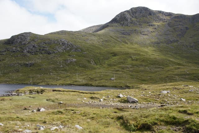
Sgaoth Aird is the dramatic 559m peak rising directly above Tarbert in Harris, its dark crags visible from the ferry pier. The summit ridge offers one of the best short hill views in the islands, taking in the Clisham group, the Minch and the beaches at Luskentyre.
Quick facts
- Height
- 559m/ 1834ft
- Prominence
- 373 m
- Grid ref
- NB 16586 03981
- Dogs
- Dogs on lead required near livestockDog-friendly guide ↗
Height and prominence cross-checked against the Database of British and Irish Hills (CC BY).
No GPX track yet
Walked this route? Share your track to help other walkers.
Standard route
blanket bog 55% · Lewisian gneiss 30% · rocky summit 15%
Start from the road end at Urgha east of Tarbert and head up the Sgaoth burn before climbing the south ridge over a series of rocky tops. Around four to five hours return with a proper sense of mountain about it.
Terrain
Wet path low down gives way to steep heather, then bare gneiss slabs and a craggy ridge. Care needed at the small rocky steps near the summit if greasy.
In winter
Snow holds intermittently above 400m and the rocky crest becomes a serious proposition in ice. Storms barrel up Loch Seaforth and across the bealach; wind is the dominant factor.
Best time of year
Getting there
- Glasgow8h 29m
- Edinburgh11h 38m
Ferry access
Uig (Skye) → Tarbert (Harris)
- Crossing time105 min
- Summer sailings2 sailings daily (Apr–Oct)
- Winter sailings1 sailing daily (Nov–Mar)
- Book ahead14 days
- Last ferry backCheck CalMac timetable — last sailing to Uig varies seasonally
Drive to Uig on Skye (Skye Bridge from Kyle of Lochalsh), then ferry to Harris. Alternative: Ullapool → Stornoway (Lewis, 2h45) and drive south.
Book on CalMac ↗OS maps: OS Landranger 13, OS Landranger 14, OS Explorer 456
Mobile signal: Poor. Both EE and Vodafone fail; North Uist trackless terrain has no signal.
Current conditions
Daylight Today
- Sunrise
- 05:16
- Sunset
- 21:51
- Civil dawn
- 04:22
- Civil dusk
- 22:46
NOAA Solar Calculator · 30 July 2026
Around Sgaoth Aird on the SCOT network
Getting there, basing yourself, and what to do off the hill.
Sgaoth Aird — common questions
- Is Sgaoth Aird a hard climb?
- Sgaoth Aird is rated 2/5 (moderate) on the OutdoorSCOT scale. Ground conditions: Wet path low down gives way to steep heather, then bare gneiss slabs and a craggy ridge.
- How much drop does Sgaoth Aird have?
- The drop is 373m: measured from the summit of Sgaoth Aird down to the saddle joining it to higher terrain. Passing the 150m-drop threshold on all sides is exactly what makes it a Marilyn.
- What's the best month to climb Sgaoth Aird?
- Aim for April, May, June, July, August, September, October on Sgaoth Aird. In the remaining months treat it as a winter hill — full kit, solid navigation, and a look at the relevant SAIS avalanche forecast before you go.
- Can dogs go up Sgaoth Aird?
- Dogs are fine on a lead. The route passes livestock or ground-nesting bird habitat, so keep them close throughout.
- Will I get phone signal on Sgaoth Aird?
- Poor. Both EE and Vodafone fail; North Uist trackless terrain has no signal.
- How do I get the ferry to Sgaoth Aird?
- Uig (Skye) → Tarbert (Harris). 2 sailings daily (Apr–Oct) in summer; 1 sailing daily (Nov–Mar) in winter. Book at least 14 days ahead. Drive to Uig on Skye (Skye Bridge from Kyle of Lochalsh), then ferry to Harris. Alternative: Ullapool → Stornoway (Lewis, 2h45) and drive south.
- Is Sgaoth Aird safe in winter?
- Snow holds intermittently above 400m and the rocky crest becomes a serious proposition in ice. Storms barrel up Loch Seaforth and across the bealach; wind is the dominant factor.
Get the OutdoorSCOT weekly
One email a week — new route, hill and bothy guides, seasonal conditions and the odd hard-won lesson. No spam, unsubscribe in one click.