Marilyn · Orkney & Shetland
Saxa Vord
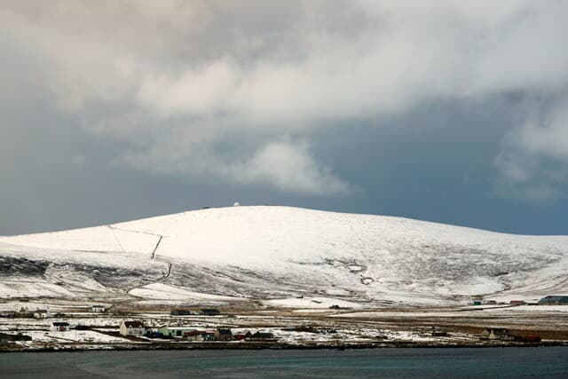
Saxa Vord crowns Unst, the most northerly inhabited island in Britain, at 284m. Long famous for its former RAF radar station and for once holding the UK windspeed record, the summit looks out over Hermaness, Muckle Flugga and the open Atlantic.
Quick facts
- Height
- 284m/ 932ft
- Prominence
- 284 m
- Grid ref
- HP 63117 16611
- Dogs
- Dogs on lead required near livestockDog-friendly guide ↗
Height and prominence cross-checked against the Database of British and Irish Hills (CC BY).
No GPX track yet
Walked this route? Share your track to help other walkers.
Standard route
heather moorland 55% · rocky slopes 30% · grass slopes 15%
The service road from Haroldswick climbs nearly to the summit — most parties walk the last 1.5km from a parking spot on the way up. A 3km round trip in well under two hours, with the masts giving an obvious target.
Terrain
Tarmac road for almost the entire route. Heather and short grass adjacent for those who prefer to leave the asphalt. The wind can make even level walking hard work.
In winter
Snow is rare but not unknown. Wind is the dominant factor and Saxa Vord is one of the windiest spots in Britain — recorded gusts have exceeded 170mph. Calm days are precious.
Best time of year
Getting there
- Glasgow16h 36m
- Edinburgh14h 1m
Ferry access
Aberdeen → Lerwick (Shetland)
- Crossing time720 min
- Summer sailingsDaily overnight sailing (Apr–Oct)
- Winter sailingsDaily overnight sailing (Nov–Mar)
- Book ahead14 days
A 12-hour overnight sailing — book a cabin berth. Plan a multi-day Shetland trip; the island is large and the journey is substantial. Flights from Aberdeen/Edinburgh are a faster alternative.
Book on ferry operator ↗OS maps: OS Landranger 1, OS Explorer 470N
Mobile signal: Poor. Remote Unst, Shetland; limited coverage (radar station here though).
Current conditions
Daylight Today
- Sunrise
- 04:33
- Sunset
- 21:47
- Civil dawn
- 03:27
- Civil dusk
- 22:53
NOAA Solar Calculator · 30 July 2026
Saxa Vord — common questions
- Is Saxa Vord a hard climb?
- Saxa Vord is rated 1/5 (easy) on the OutdoorSCOT scale. Ground conditions: Tarmac road for almost the entire route.
- How much drop does Saxa Vord have?
- Saxa Vord's prominence is its full height — 284m — because it is the highest point of its landmass, with no higher ground connected to it. Passing the 150m-drop threshold on all sides is exactly what makes it a Marilyn.
- What's the best month to climb Saxa Vord?
- Aim for March, April, May, June, July, August, September, October on Saxa Vord. In the remaining months treat it as a winter hill — full kit, solid navigation, and a look at the relevant SAIS avalanche forecast before you go.
- Can dogs go up Saxa Vord?
- Dogs are fine on a lead. The route passes livestock or ground-nesting bird habitat, so keep them close throughout.
- Will I get phone signal on Saxa Vord?
- Poor. Remote Unst, Shetland; limited coverage (radar station here though).
- How do I get the ferry to Saxa Vord?
- Aberdeen → Lerwick (Shetland). Daily overnight sailing (Apr–Oct) in summer; Daily overnight sailing (Nov–Mar) in winter. Book at least 14 days ahead. A 12-hour overnight sailing — book a cabin berth. Plan a multi-day Shetland trip; the island is large and the journey is substantial. Flights from Aberdeen/Edinburgh are a faster alternative.
- Is Saxa Vord safe in winter?
- Snow is rare but not unknown. Wind is the dominant factor and Saxa Vord is one of the windiest spots in Britain — recorded gusts have exceeded 170mph. Calm days are precious.
Get the OutdoorSCOT weekly
One email a week — new route, hill and bothy guides, seasonal conditions and the odd hard-won lesson. No spam, unsubscribe in one click.