Sub-Marilyn · Orkney & Shetland
Hill of Clibberswick
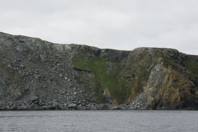
The Hill of Clibberswick is the north-eastern Marilyn of Unst, looking out over the Skaw peninsula and the easternmost houses in Britain. The 160m top sits above remarkable serpentinite cliffs where the Caledonian fold meets the open North Sea.
Quick facts
- Height
- 160.5m/ 527ft
- Prominence
- 149 m
- Grid ref
- HP 66240 12660
- Dogs
- Dogs on lead required near livestockDog-friendly guide ↗
Sub-Marilyn: 149m of drop — misses the 150m Marilyn cut by 1m. We keep it on the list as a near-miss.
Height and prominence cross-checked against the Database of British and Irish Hills (CC BY).
No GPX track yet
Walked this route? Share your track to help other walkers.
Standard route
heather moorland 60% · grass slopes 25% · rocky summit 15%
A short walk from the road end at Norwick or Skaw, climbing through grazing and onto the open hill. Combine with a visit to the bird-rich beach at Norwick for a richer day out on this corner of Unst.
Terrain
Thin soils over serpentine rock support an unusual maritime flora — a mosaic of heather, grass and bare rock unlike the deep peat further south. Underfoot is firmer than most Shetland hills.
In winter
Two ferry hops needed to reach Unst and winter sailings are at the mercy of north-easterly weather. Snow rare but the sea spray on east winds is striking.
Best time of year
Getting there
- Glasgow16h 36m
- Edinburgh14h 0m
Ferry access
Aberdeen → Lerwick (Shetland)
- Crossing time720 min
- Summer sailingsDaily overnight sailing (Apr–Oct)
- Winter sailingsDaily overnight sailing (Nov–Mar)
- Book ahead14 days
A 12-hour overnight sailing — book a cabin berth. Plan a multi-day Shetland trip; the island is large and the journey is substantial. Flights from Aberdeen/Edinburgh are a faster alternative.
Book on ferry operator ↗OS maps: OS Landranger 1, OS Explorer 470N
Mobile signal: Poor. Remote Unst, Shetland; limited coverage.
Current conditions
Daylight Today
- Sunrise
- 06:27
- Sunset
- 19:31
- Civil dawn
- 05:43
- Civil dusk
- 20:14
NOAA Solar Calculator · 14 September 2026
Hill of Clibberswick — common questions
- What difficulty is Hill of Clibberswick?
- On the OutdoorSCOT scale, Hill of Clibberswick comes in at 1/5 — easy. Underfoot: Thin soils over serpentine rock support an unusual maritime flora — a mosaic of heather, grass and bare rock unlike the deep peat further south.
- What is Hill of Clibberswick's prominence?
- 149m of prominence. That's the vertical drop from the summit to the col that links Hill of Clibberswick to the next higher ground. That leaves it 1m short of the 150m drop a Marilyn needs — DoBIH classes it a sub-Marilyn, a near-miss rather than a full Marilyn.
- When is the best time to climb Hill of Clibberswick?
- March, April, May, June, July, August, September, October give the most reliable conditions on Hill of Clibberswick. Beyond that window the high ground turns wintry: carry full mountain kit, be confident navigating, and check the SAIS avalanche forecast for the area.
- Is Hill of Clibberswick dog-friendly?
- Yes, but dogs must be kept on a lead — there is livestock or ground-nesting bird interest on the route.
- Is there mobile signal on Hill of Clibberswick?
- Poor. Remote Unst, Shetland; limited coverage.
- How do I get the ferry to Hill of Clibberswick?
- Aberdeen → Lerwick (Shetland). Daily overnight sailing (Apr–Oct) in summer; Daily overnight sailing (Nov–Mar) in winter. Book at least 14 days ahead. A 12-hour overnight sailing — book a cabin berth. Plan a multi-day Shetland trip; the island is large and the journey is substantial. Flights from Aberdeen/Edinburgh are a faster alternative.
- Is Hill of Clibberswick safe in winter?
- Two ferry hops needed to reach Unst and winter sailings are at the mercy of north-easterly weather. Snow rare but the sea spray on east winds is striking.
Get the OutdoorSCOT weekly
One email a week — new route, hill and bothy guides, seasonal conditions and the odd hard-won lesson. No spam, unsubscribe in one click.