Marilyn · Ochils
Moncreiffe Hill
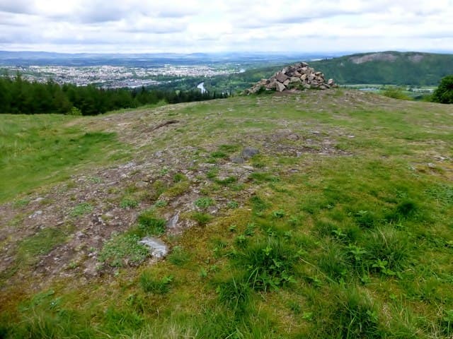
Moncreiffe Hill is a wooded knot just south of Perth at NO13, with the River Tay swinging around its northern foot. The 223m summit and its Iron Age fort sit within Moncreiffe Hill Wood, managed by the Woodland Trust.
Quick facts
- Height
- 223m/ 732ft
- Prominence
- 185 m
- Grid ref
- NO 13578 19972
- Parking
- NO 135 202
- Nearest city
- Perth· 4km
- Dogs
- Dogs on lead required near livestockDog-friendly guide ↗
Height and prominence cross-checked against the Database of British and Irish Hills (CC BY).
No GPX track yet
Walked this route? Share your track to help other walkers.
Standard route
deciduous woodland 60% · heather/bracken 25% · rocky summit 15%
From the Woodland Trust car park at Walnut Grove follow the waymarked trails uphill through oak and Douglas fir to the Moredun Top viewpoint. A separate spur leads to the highest point at Moncreiffe Hill itself.
Terrain
Wide stone tracks and pine-needle paths throughout the wood. Steep in places but well-maintained by the Woodland Trust with clear waymarking.
In winter
Excellent winter walk under tree cover. Ice on the steeper tracks after thaw is the main hazard; otherwise a reliable cold-weather option close to Perth.
Best time of year
Getting there
- Glasgow3h 33m
- Edinburgh1h 12m
OS maps: OS Landranger 58, OS Explorer 369, OS Explorer 380W
Mobile signal: Good. Perth; EE excellent — suburban summit.
Current conditions
Daylight Today
- Sunrise
- 05:11
- Sunset
- 21:29
- Civil dawn
- 04:21
- Civil dusk
- 22:19
NOAA Solar Calculator · 30 July 2026
Around Moncreiffe Hill on the SCOT network
Getting there, basing yourself, and what to do off the hill.
Moncreiffe Hill — common questions
- How difficult is Moncreiffe Hill?
- Moncreiffe Hill carries a 1/5 (easy) grade on the OutdoorSCOT scale. Terrain: Wide stone tracks and pine-needle paths throughout the wood.
- How prominent is Moncreiffe Hill?
- Moncreiffe Hill has 185m of topographic prominence — the height of its summit above the highest col connecting it to higher ground. Marilyns are defined by that measure: at least 150m of drop on all sides.
- Where should I park to climb Moncreiffe Hill?
- Standard parking is at NO 135 202. Check the parking grid reference on an OS map before travel; informal laybys can fill on summer weekends.
- When should I climb Moncreiffe Hill?
- The standard good-weather months for Moncreiffe Hill are March, April, May, June, July, August, September, October. Outside those months, expect winter conditions on the high ground — full mountain kit, navigation skills, and a check of the SAIS avalanche forecast for the relevant region.
- Can I bring my dog up Moncreiffe Hill?
- On a lead only — the route crosses ground with livestock or nesting-bird interest.
- What's mobile reception like on Moncreiffe Hill?
- Good. Perth; EE excellent — suburban summit.
- Is Moncreiffe Hill safe in winter?
- Excellent winter walk under tree cover. Ice on the steeper tracks after thaw is the main hazard; otherwise a reliable cold-weather option close to Perth.
Get the OutdoorSCOT weekly
One email a week — new route, hill and bothy guides, seasonal conditions and the odd hard-won lesson. No spam, unsubscribe in one click.