Marilyn · Orkney & Shetland
Hill of Arisdale
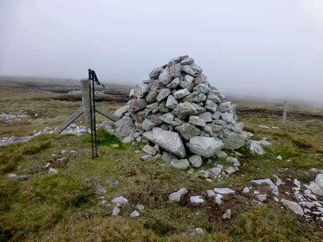
The Hill of Arisdale is the high point of Yell, the great peat island that sits between the Shetland Mainland and Unst. At 210m it crowns a roadless interior of bog and lochans that earned Yell its reputation as the bleakest of the Shetland isles — though the views over Yell Sound are anything but bleak.
Quick facts
- Height
- 210m/ 689ft
- Prominence
- 210 m
- Grid ref
- HU 49451 84158
- Dogs
- Dogs on lead required near livestockDog-friendly guide ↗
Height and prominence cross-checked against the Database of British and Irish Hills (CC BY).
No GPX track yet
Walked this route? Share your track to help other walkers.
Standard route
blanket bog 60% · heather moorland 25% · rocky summit 15%
Walkers start from the B9081 near the head of Mid Yell Voe or from Arisdale itself, then strike west into the peat. There is no path; pick the highest visible point and zig-zag to avoid the deepest hags.
Terrain
Yell is almost entirely blanket bog and this hill is no exception — peat hags up to a metre deep, dubh lochans and stretches of bare gravel near the summit. Going is slow even in dry spells.
In winter
The peat freezes only in deep cold spells; for most of winter the ground stays sodden. Ferry from Toft on the Mainland runs reliably but is exposed to north-easterly gales.
Best time of year
Getting there
- Glasgow15h 36m
- Edinburgh13h 3m
Ferry access
Aberdeen → Lerwick (Shetland)
- Crossing time720 min
- Summer sailingsDaily overnight sailing (Apr–Oct)
- Winter sailingsDaily overnight sailing (Nov–Mar)
- Book ahead14 days
A 12-hour overnight sailing — book a cabin berth. Plan a multi-day Shetland trip; the island is large and the journey is substantial. Flights from Aberdeen/Edinburgh are a faster alternative.
Book on ferry operator ↗OS maps: OS Landranger 1, OS Landranger 2, OS Landranger 3, OS Explorer 470S
Mobile signal: Poor. Remote Yell, Shetland; limited coverage.
Current conditions
Daylight Today
- Sunrise
- 06:29
- Sunset
- 19:32
- Civil dawn
- 05:45
- Civil dusk
- 20:15
NOAA Solar Calculator · 14 September 2026
Hill of Arisdale — common questions
- How hard is Hill of Arisdale?
- We grade Hill of Arisdale at 1/5, which puts it in easy territory. Terrain: Yell is almost entirely blanket bog and this hill is no exception — peat hags up to a metre deep, dubh lochans and stretches of bare gravel near the summit.
- How prominent is Hill of Arisdale?
- Hill of Arisdale's prominence is its full height — 210m — because it is the highest point of its landmass, with no higher ground connected to it. Marilyns are defined by that measure: at least 150m of drop on all sides.
- When should I climb Hill of Arisdale?
- The standard good-weather months for Hill of Arisdale are March, April, May, June, July, August, September, October. Outside those months, expect winter conditions on the high ground — full mountain kit, navigation skills, and a check of the SAIS avalanche forecast for the relevant region.
- Can I bring my dog up Hill of Arisdale?
- On a lead only — the route crosses ground with livestock or nesting-bird interest.
- What's mobile reception like on Hill of Arisdale?
- Poor. Remote Yell, Shetland; limited coverage.
- How do I get the ferry to Hill of Arisdale?
- Aberdeen → Lerwick (Shetland). Daily overnight sailing (Apr–Oct) in summer; Daily overnight sailing (Nov–Mar) in winter. Book at least 14 days ahead. A 12-hour overnight sailing — book a cabin berth. Plan a multi-day Shetland trip; the island is large and the journey is substantial. Flights from Aberdeen/Edinburgh are a faster alternative.
- Is Hill of Arisdale safe in winter?
- The peat freezes only in deep cold spells; for most of winter the ground stays sodden. Ferry from Toft on the Mainland runs reliably but is exposed to north-easterly gales.
Get the OutdoorSCOT weekly
One email a week — new route, hill and bothy guides, seasonal conditions and the odd hard-won lesson. No spam, unsubscribe in one click.