Sub-Marilyn · Orkney & Shetland
Faan Hill
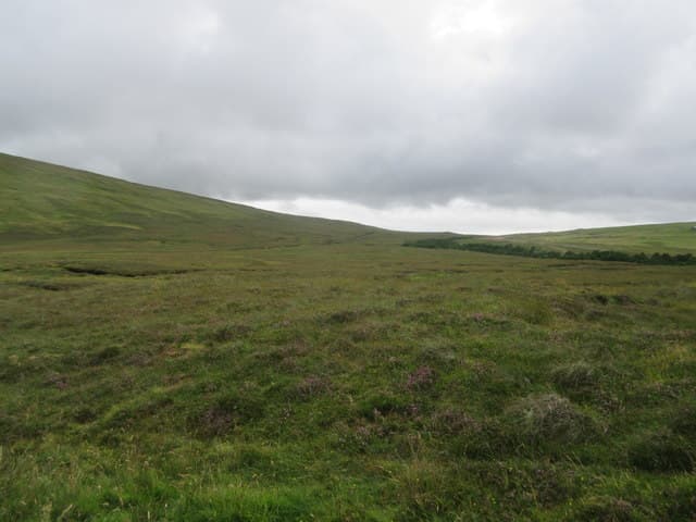
Faan Hill rises from the interior of Northmavine, the rugged north-western limb of the Shetland Mainland. The 171m summit looks south over Sullom Voe and north towards the cliffs of Ronas Voe; for a small hill it has a remarkably wide outlook.
Quick facts
- Height
- 171.3m/ 562ft
- Prominence
- 149 m
- Grid ref
- HU 34466 80189
- Dogs
- Dogs on lead required near livestockDog-friendly guide ↗
Sub-Marilyn: 149m of drop — misses the 150m Marilyn cut by 1m. We keep it on the list as a near-miss.
Height and prominence cross-checked against the Database of British and Irish Hills (CC BY).
No GPX track yet
Walked this route? Share your track to help other walkers.
Standard route
blanket bog 55% · heather moorland 30% · rocky summit 15%
Start from the A970 lay-by near Mavis Grind or from the lane towards Gunnister and pick a line up through heather and peat to the summit. The walk is short but committing in poor visibility.
Terrain
Mostly heather with peat hags in the hollows and ribs of granite near the top. Sphagnum patches mark the boggiest sections — they are usually obvious once you know what to look for.
In winter
Mavis Grind, the narrow neck of land below, gets battered by both Atlantic and North Sea storms simultaneously. The hill itself stays snow-free most of the season but is rarely calm.
Best time of year
Getting there
- Glasgow14h 8m
- Edinburgh13h 41m
Ferry access
Aberdeen → Lerwick (Shetland)
- Crossing time720 min
- Summer sailingsDaily overnight sailing (Apr–Oct)
- Winter sailingsDaily overnight sailing (Nov–Mar)
- Book ahead14 days
A 12-hour overnight sailing — book a cabin berth. Plan a multi-day Shetland trip; the island is large and the journey is substantial. Flights from Aberdeen/Edinburgh are a faster alternative.
Book on ferry operator ↗OS maps: OS Landranger 1, OS Landranger 2, OS Landranger 3, OS Explorer 469N
Mobile signal: Poor. West Shetland interior; EE fails. Lerwick is the nearest reliable coverage.
Current conditions
Daylight Today
- Sunrise
- 06:30
- Sunset
- 19:33
- Civil dawn
- 05:47
- Civil dusk
- 20:16
NOAA Solar Calculator · 14 September 2026
Faan Hill — common questions
- What difficulty is Faan Hill?
- On the OutdoorSCOT scale, Faan Hill comes in at 1/5 — easy. Terrain: Mostly heather with peat hags in the hollows and ribs of granite near the top.
- How prominent is Faan Hill?
- Faan Hill has 149m of topographic prominence — the height of its summit above the highest col connecting it to higher ground. That leaves it 1m short of the 150m drop a Marilyn needs — DoBIH classes it a sub-Marilyn, a near-miss rather than a full Marilyn.
- When should I climb Faan Hill?
- The standard good-weather months for Faan Hill are March, April, May, June, July, August, September, October. Outside those months, expect winter conditions on the high ground — full mountain kit, navigation skills, and a check of the SAIS avalanche forecast for the relevant region.
- Can I bring my dog up Faan Hill?
- On a lead only — the route crosses ground with livestock or nesting-bird interest.
- What's mobile reception like on Faan Hill?
- Poor. West Shetland interior; EE fails. Lerwick is the nearest reliable coverage.
- How do I get the ferry to Faan Hill?
- Aberdeen → Lerwick (Shetland). Daily overnight sailing (Apr–Oct) in summer; Daily overnight sailing (Nov–Mar) in winter. Book at least 14 days ahead. A 12-hour overnight sailing — book a cabin berth. Plan a multi-day Shetland trip; the island is large and the journey is substantial. Flights from Aberdeen/Edinburgh are a faster alternative.
- Is Faan Hill safe in winter?
- Mavis Grind, the narrow neck of land below, gets battered by both Atlantic and North Sea storms simultaneously. The hill itself stays snow-free most of the season but is rarely calm.
Get the OutdoorSCOT weekly
One email a week — new route, hill and bothy guides, seasonal conditions and the odd hard-won lesson. No spam, unsubscribe in one click.