Marilyn · Orkney & Shetland
Fitty Hill
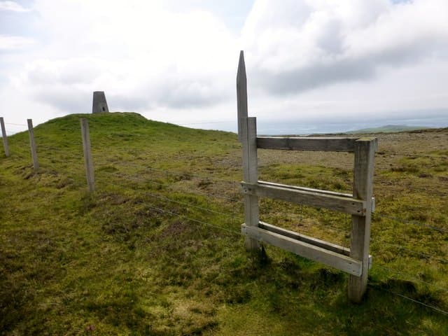
Fitty Hill is the highest point on Westray, the green northern island of the Orkney archipelago. Reaching only 169m it has enough prominence to dominate the island skyline, with cliff coasts, Atlantic surf and seabird colonies wrapped around its base.
Quick facts
- Height
- 169m/ 554ft
- Prominence
- 169 m
- Grid ref
- HY 42975 44857
- Dogs
- Dogs on lead required near livestockDog-friendly guide ↗
Height and prominence cross-checked against the Database of British and Irish Hills (CC BY).
No GPX track yet
Walked this route? Share your track to help other walkers.
Standard route
grass moorland 70% · heather patches 20% · summit area 10%
A pleasant short walk from the road near Cleat or Bistermire, crossing improved pasture and rough grass to a small cairned summit. Round trip is typically 3-4km and takes 1-2 hours; many visitors combine the walk with the Castle o'Burrian seabird cliffs.
Terrain
Cropped sheep pasture, marshy hollows and a heathery summit dome. Stiles and barbed-wire fences punctuate the route. Salt-laden Atlantic wind is the dominant terrain factor.
In winter
A mild, wind-lashed maritime winter with rain rather than snow. Ferry crossings can be cancelled in storms, so plan a flexible visit. Short days mean an early start even on a tiny hill.
Best time of year
Getting there
- Glasgow9h 26m
- Edinburgh9h 39m
Ferry access
Scrabster → Stromness (Orkney)
- Crossing time90 min
- Summer sailings3 sailings daily (Apr–Oct)
- Winter sailings2 sailings daily (Nov–Mar)
- Book ahead7 days
- Last ferry backCheck NorthLink timetable — last sailing back varies seasonally
Alternative: Pentland Ferries from Gills Bay → St Margaret's Hope (1h, more frequent) or Aberdeen → Kirkwall overnight. Hoy hills are a further short inter-island ferry hop from Stromness.
Book on ferry operator ↗OS maps: OS Landranger 5, OS Explorer 464
Mobile signal: Poor. Westray island, Orkney; signal absent on this summit. Ferry required.
Current conditions
Daylight Today
- Sunrise
- 04:52
- Sunset
- 21:45
- Civil dawn
- 03:53
- Civil dusk
- 22:44
NOAA Solar Calculator · 30 July 2026
Fitty Hill — common questions
- How difficult is Fitty Hill?
- Fitty Hill carries a 1/5 (easy) grade on the OutdoorSCOT scale. Underfoot: Cropped sheep pasture, marshy hollows and a heathery summit dome.
- What is Fitty Hill's prominence?
- Fitty Hill's prominence is its full height — 169m — because it is the highest point of its landmass, with no higher ground connected to it. That drop is what qualifies it as a Marilyn — a hill with at least 150m of descent on every side.
- When is the best time to climb Fitty Hill?
- March, April, May, June, July, August, September, October give the most reliable conditions on Fitty Hill. Beyond that window the high ground turns wintry: carry full mountain kit, be confident navigating, and check the SAIS avalanche forecast for the area.
- Is Fitty Hill dog-friendly?
- Yes, but dogs must be kept on a lead — there is livestock or ground-nesting bird interest on the route.
- Is there mobile signal on Fitty Hill?
- Poor. Westray island, Orkney; signal absent on this summit. Ferry required.
- How do I get the ferry to Fitty Hill?
- Scrabster → Stromness (Orkney). 3 sailings daily (Apr–Oct) in summer; 2 sailings daily (Nov–Mar) in winter. Book at least 7 days ahead. Alternative: Pentland Ferries from Gills Bay → St Margaret's Hope (1h, more frequent) or Aberdeen → Kirkwall overnight. Hoy hills are a further short inter-island ferry hop from Stromness.
- Is Fitty Hill safe in winter?
- A mild, wind-lashed maritime winter with rain rather than snow. Ferry crossings can be cancelled in storms, so plan a flexible visit. Short days mean an early start even on a tiny hill.
Get the OutdoorSCOT weekly
One email a week — new route, hill and bothy guides, seasonal conditions and the odd hard-won lesson. No spam, unsubscribe in one click.