Marilyn · Ochils
Duncolm
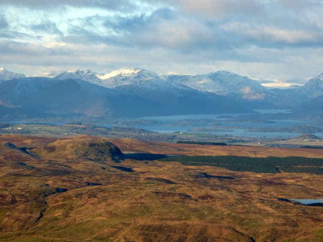
Duncolm is the highest of the Kilpatrick Hills above the Clyde at NS47, a 401m basalt summit overlooking Old Kilpatrick, Bowling and the river. Reservoirs dot the moor and views stretch to Loch Lomond and Ben Lomond.
Quick facts
- Height
- 401.1m/ 1316ft
- Prominence
- 305 m
- Grid ref
- NS 47085 77486
- Parking
- NS 472 740
- Nearest city
- Glasgow· 17km
- Dogs
- Dogs on lead required near livestockDog-friendly guide ↗
Height and prominence cross-checked against the Database of British and Irish Hills (CC BY).
No GPX track yet
Walked this route? Share your track to help other walkers.
Standard route
volcanic basalt 45% · heather moorland 35% · grass slopes 20%
Walk in from Greenside Reservoir car park near Old Kilpatrick, following the reservoir track north onto the open moor. A faint quad track crosses the bog to gain the rocky summit and OS pillar.
Terrain
Pathless heather and peat hags between the reservoirs, with rougher tussocks on the final pull. Best walked after dry weather to avoid the worst of the bog.
In winter
Low Kilpatricks rarely see lasting snow but the peat plateau ices over and stays cold. The reservoir tracks remain usable through most of winter.
Best time of year
Getting there
- Glasgow1h 35m
- Edinburgh3h 16m
OS maps: OS Landranger 64, OS Explorer 0038, OS Explorer 347
Mobile signal: Good. Central belt north of Glasgow; EE reliable.
Current conditions
Daylight Today
- Sunrise
- 05:18
- Sunset
- 21:31
- Civil dawn
- 04:29
- Civil dusk
- 22:20
NOAA Solar Calculator · 30 July 2026
Around Duncolm on the SCOT network
Getting there, basing yourself, and what to do off the hill.
Getting there: Balloch station
South Loch Lomond — WHW start at Drymen / Conic Hill
9km from the hill
tripscot.co.uk
On TripSCOTBase yourself in Luss
West Loch Lomond village — Highland Boundary, Loch Lomond Way
19km from the hill
tripscot.co.uk
On TasteSCOTAfter the hill: Auchentoshan
Clydebank — Scotland's only triple-distilled single malt; 10 min from Glasgow
5km from the hill
tastescot.co.uk
Duncolm — common questions
- What difficulty is Duncolm?
- On the OutdoorSCOT scale, Duncolm comes in at 1/5 — easy. Terrain: Pathless heather and peat hags between the reservoirs, with rougher tussocks on the final pull.
- How prominent is Duncolm?
- Duncolm has 305m of topographic prominence — the height of its summit above the highest col connecting it to higher ground. Marilyns are defined by that measure: at least 150m of drop on all sides.
- Where should I park to climb Duncolm?
- Standard parking is at NS 472 740. Check the parking grid reference on an OS map before travel; informal laybys can fill on summer weekends.
- When should I climb Duncolm?
- The standard good-weather months for Duncolm are March, April, May, June, July, August, September, October. Outside those months, expect winter conditions on the high ground — full mountain kit, navigation skills, and a check of the SAIS avalanche forecast for the relevant region.
- Can I bring my dog up Duncolm?
- On a lead only — the route crosses ground with livestock or nesting-bird interest.
- What's mobile reception like on Duncolm?
- Good. Central belt north of Glasgow; EE reliable.
- Is Duncolm safe in winter?
- Low Kilpatricks rarely see lasting snow but the peat plateau ices over and stays cold. The reservoir tracks remain usable through most of winter.
Get the OutdoorSCOT weekly
One email a week — new route, hill and bothy guides, seasonal conditions and the odd hard-won lesson. No spam, unsubscribe in one click.