Marilyn · Skye
Dun Caan
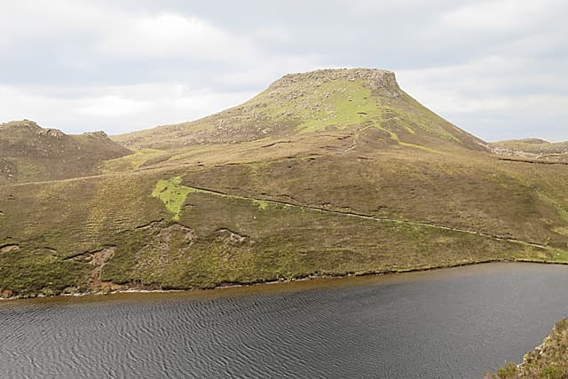
Dun Caan is the unmistakable flat-topped volcanic plug at the heart of the Isle of Raasay, famous as the spot where Boswell danced a Highland fling in 1773. The NG 57 39 grid puts the summit on an island reached by short ferry crossing from Sconser on Skye, with views encompassing the Cuillin, Trotternish and the Applecross hills.
Quick facts
- Height
- 444m/ 1457ft
- Prominence
- 444 m
- Grid ref
- NG 57918 39483
- Dogs
- Dogs on lead required near livestockDog-friendly guide ↗
Height and prominence cross-checked against the Database of British and Irish Hills (CC BY).
No GPX track yet
Walked this route? Share your track to help other walkers.
Standard route
heather moorland 55% · rocky summit 30% · grass slopes 15%
From Inverarish (NG 55 36) or the old miners' track at Inverarish Burn, follow the well-trodden path east across the moor and around the south side of the cone, climbing the final slope to gain the flat summit. Around 11 km return with 500m of climb.
Terrain
A clear path crosses bog and heather to the foot of the cone, where a steep stony pull leads onto the truncated summit plateau. The path is muddy in places but well-defined throughout.
In winter
Snow occasionally settles on the summit plateau but rarely persists. The final steep stony slope ices over in cold spells, requiring care on the descent. Ferry sailings can be disrupted by winter storms.
Best time of year
Getting there
- Glasgow6h 3m
- Edinburgh8h 14m
OS maps: OS Landranger 24, OS Landranger 32, OS Explorer 409
Mobile signal: Expect little. Remote Raasay; faint on most networks.
Current conditions
Daylight Today
- Sunrise
- 05:16
- Sunset
- 21:45
- Civil dawn
- 04:23
- Civil dusk
- 22:38
NOAA Solar Calculator · 30 July 2026
Around Dun Caan on the SCOT network
Getting there, basing yourself, and what to do off the hill.
Getting there: Kyle of Lochalsh station
Skye Bridge; Five Sisters of Kintail; Glen Shiel; Plockton
22km from the hill
tripscot.co.uk
On TripSCOTBase yourself in Portree
Main Skye base — Cuillin, Trotternish, Storr
11km from the hill
tripscot.co.uk
On TasteSCOTAfter the hill: Isle of Raasay Distillery
Raasay — new island distillery with rooms; Dun Caan walks from the door
4km from the hill
tastescot.co.uk
Dun Caan — common questions
- How hard is Dun Caan?
- We grade Dun Caan at 1/5, which puts it in easy territory. Underfoot: A clear path crosses bog and heather to the foot of the cone, where a steep stony pull leads onto the truncated summit plateau.
- What is Dun Caan's prominence?
- Dun Caan's prominence is its full height — 444m — because it is the highest point of its landmass, with no higher ground connected to it. That drop is what qualifies it as a Marilyn — a hill with at least 150m of descent on every side.
- When is the best time to climb Dun Caan?
- March, April, May, June, July, August, September, October give the most reliable conditions on Dun Caan. Beyond that window the high ground turns wintry: carry full mountain kit, be confident navigating, and check the SAIS avalanche forecast for the area.
- Is Dun Caan dog-friendly?
- Yes, but dogs must be kept on a lead — there is livestock or ground-nesting bird interest on the route.
- Is there mobile signal on Dun Caan?
- Expect little. Remote Raasay; faint on most networks.
- Is Dun Caan safe in winter?
- Snow occasionally settles on the summit plateau but rarely persists. The final steep stony slope ices over in cold spells, requiring care on the descent. Ferry sailings can be disrupted by winter storms.
Get the OutdoorSCOT weekly
One email a week — new route, hill and bothy guides, seasonal conditions and the odd hard-won lesson. No spam, unsubscribe in one click.