Sub-Marilyn · Glen Coe & Lochaber
Cruim Leacainn
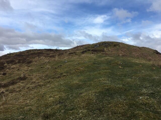
Cruim Leacainn — the curved hillside — is a 231m Marilyn in NN-square Lochaber, set on the west side of the Great Glen between Gairlochy and Invergloy a little north of Spean Bridge. Despite its very modest height the summit gives a fine vantage over Loch Lochy and the Commando Memorial.
Quick facts
- Height
- 231.1m/ 758ft
- Prominence
- 149 m
- Grid ref
- NN 16670 80738
- Nearest city
- Fort William· 9km
- Dogs
- Dogs on lead required near livestockDog-friendly guide ↗
Sub-Marilyn: 149m of drop — misses the 150m Marilyn cut by 1m. We keep it on the list as a near-miss.
Height and prominence cross-checked against the Database of British and Irish Hills (CC BY).
No GPX track yet
Walked this route? Share your track to help other walkers.
Standard route
heather moorland 60% · grass slopes 30% · rocky summit 10%
Start from the B8005 north of Gairlochy, finding parking near the lochside cottages. A faint track climbs through bracken and birch onto open hillside, then turns south along the small crest to a rocky knoll above the loch.
Terrain
Birch, bracken and gorse on the lower slope, with patches of clearfelled forestry and short heather above. Wet patches lie between the bracken stands; the summit knoll itself is dry slabby ground.
In winter
A 231m hill beside an ice-free freshwater loch — snow is incidental. The real winter hazards are wet leaves on the steep approach turning to glass under hard frost, and short daylight in the wooded gulley.
This hill is in the Glen Coe SAIS forecast area. Check SAIS forecasts in winter (December–April).
Best time of year
Getting there
- Glasgow3h 17m
- Edinburgh5h 17m
OS maps: OS Landranger 34, OS Landranger 41, OS Explorer 392, OS Explorer 399
Mobile signal: Poor. Remote Loch Laggan/Creag Meagaidh area; limited coverage.
Current conditions
Daylight Today
- Sunrise
- 05:15
- Sunset
- 21:38
- Civil dawn
- 04:24
- Civil dusk
- 22:30
NOAA Solar Calculator · 30 July 2026
Around Cruim Leacainn on the SCOT network
Getting there, basing yourself, and what to do off the hill.
Base yourself in Fort William
Ben Nevis base, West Highland Line, gateway to Lochaber
9km from the hill
tripscot.co.uk
On TasteSCOTAfter the hill: Ben Nevis Distillery
Fort William — Lochaber distillery at the foot of the Ben; long-aged Japanese-owned classics
6km from the hill
tastescot.co.uk
Cruim Leacainn — common questions
- What difficulty is Cruim Leacainn?
- On the OutdoorSCOT scale, Cruim Leacainn comes in at 1/5 — easy. Ground conditions: Birch, bracken and gorse on the lower slope, with patches of clearfelled forestry and short heather above.
- How much drop does Cruim Leacainn have?
- The drop is 149m: measured from the summit of Cruim Leacainn down to the saddle joining it to higher terrain. That leaves it 1m short of the 150m drop a Marilyn needs — DoBIH classes it a sub-Marilyn, a near-miss rather than a full Marilyn.
- What's the best month to climb Cruim Leacainn?
- Aim for March, April, May, June, July, August, September, October on Cruim Leacainn. In the remaining months treat it as a winter hill — full kit, solid navigation, and a look at the relevant SAIS avalanche forecast before you go.
- Can dogs go up Cruim Leacainn?
- Dogs are fine on a lead. The route passes livestock or ground-nesting bird habitat, so keep them close throughout.
- Will I get phone signal on Cruim Leacainn?
- Poor. Remote Loch Laggan/Creag Meagaidh area; limited coverage.
- Is Cruim Leacainn safe in winter?
- A 231m hill beside an ice-free freshwater loch — snow is incidental. The real winter hazards are wet leaves on the steep approach turning to glass under hard frost, and short daylight in the wooded gulley.
Get the OutdoorSCOT weekly
One email a week — new route, hill and bothy guides, seasonal conditions and the odd hard-won lesson. No spam, unsubscribe in one click.