Marilyn · Argyll
Cnoc Reamhar
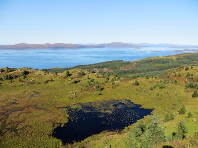
Cnoc Reamhar — the Fat Knoll — is a broad 266m forested hill in Knapdale north of Tarbert. From the open patches near its top, walkers look across to the Sound of Bute and the Cowal hills.
Quick facts
- Height
- 266m/ 873ft
- Prominence
- 217 m
- Grid ref
- NR 76645 91242
- Nearest city
- Oban· 40km
- Dogs
- Dogs on lead required near livestockDog-friendly guide ↗
Height and prominence cross-checked against the Database of British and Irish Hills (CC BY).
No GPX track yet
Walked this route? Share your track to help other walkers.
Standard route
heather moorland 65% · grass slopes 25% · rocky summit 10%
Forest tracks from Inverneill on Loch Fyne climb the eastern flank before a short heather pull reaches the cairn. Two to three hours return.
Terrain
Well-graded forest road eases the climb. Replanted areas can be brashy and tussocky near the felled summit clearing.
In winter
Sheltered woodland keeps the route walkable in most winters. Snow is uncommon but tracks can ice over.
Best time of year
Getting there
- Glasgow4h 30m
- Edinburgh6h 13m
OS maps: OS Landranger 55, OS Explorer 358N
Mobile signal: Minimal. EE registers nothing on this remote Kintyre interior hill.
Current conditions
Daylight Today
- Sunrise
- 05:22
- Sunset
- 21:36
- Civil dawn
- 04:32
- Civil dusk
- 22:25
NOAA Solar Calculator · 30 July 2026
Around Cnoc Reamhar on the SCOT network
Getting there, basing yourself, and what to do off the hill.
Cnoc Reamhar — common questions
- How difficult is Cnoc Reamhar?
- Cnoc Reamhar carries a 1/5 (easy) grade on the OutdoorSCOT scale. Underfoot: Well-graded forest road eases the climb.
- What is Cnoc Reamhar's prominence?
- 217m of prominence. That's the vertical drop from the summit to the col that links Cnoc Reamhar to the next higher ground. That drop is what qualifies it as a Marilyn — a hill with at least 150m of descent on every side.
- When is the best time to climb Cnoc Reamhar?
- March, April, May, June, July, August, September, October give the most reliable conditions on Cnoc Reamhar. Beyond that window the high ground turns wintry: carry full mountain kit, be confident navigating, and check the SAIS avalanche forecast for the area.
- Is Cnoc Reamhar dog-friendly?
- Yes, but dogs must be kept on a lead — there is livestock or ground-nesting bird interest on the route.
- Is there mobile signal on Cnoc Reamhar?
- Minimal. EE registers nothing on this remote Kintyre interior hill.
- Is Cnoc Reamhar safe in winter?
- Sheltered woodland keeps the route walkable in most winters. Snow is uncommon but tracks can ice over.
Get the OutdoorSCOT weekly
One email a week — new route, hill and bothy guides, seasonal conditions and the odd hard-won lesson. No spam, unsubscribe in one click.