Marilyn · Kintail
Beinn a' Chaoinich
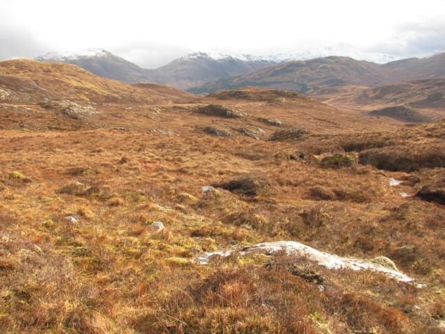
Beinn a Chaoinich, the hill of the moss, is a 410m heather hump on the Glenelg peninsula north of Loch Hourn. The summit looks south across Knoydart, west to Skye and east toward the Five Sisters of Kintail — a remarkable view for so modest a hill.
Quick facts
- Height
- 410m/ 1345ft
- Prominence
- 272 m
- Grid ref
- NG 85989 18385
- Nearest city
- Inverness· 85km
- Dogs
- Dogs on lead required near livestockDog-friendly guide ↗
Height and prominence cross-checked against the Database of British and Irish Hills (CC BY).
No GPX track yet
Walked this route? Share your track to help other walkers.
Standard route
heather and bog 65% · grass slopes 25% · rocky summit 10%
From the road end at Corran on Loch Hourn, take the path up the Allt Mhalagain and break off west onto the heather hillside. The summit is a featureless heather dome; in clear weather the surrounding panorama makes up for it. Around 2 to 3 hours.
Terrain
True to its name — sphagnum moss and wet heather across most of the ascent, with the bog quickening near the summit. The bedrock is Moine schist; rock barely shows except on the loch-facing flanks.
In winter
A coastal hill at 410m. Snow is brief and partial; the real winter problem is wet ground freezing into hidden ice plates under fresh snow. Spikes useful for the upper bog; the views to Knoydart in winter sunshine are exceptional.
Best time of year
Getting there
- Glasgow5h 50m
- Edinburgh7h 54m
OS maps: OS Landranger 33, OS Explorer 413N
Mobile signal: Patchy. Reception across the Sound to Skye masts on the summit; the Loch Hourn shore is largely dead.
Current conditions
Daylight Today
- Sunrise
- 05:15
- Sunset
- 21:42
- Civil dawn
- 04:23
- Civil dusk
- 22:34
NOAA Solar Calculator · 30 July 2026
Around Beinn a' Chaoinich on the SCOT network
Getting there, basing yourself, and what to do off the hill.
Beinn a' Chaoinich — common questions
- How hard is Beinn a' Chaoinich?
- We grade Beinn a' Chaoinich at 1/5, which puts it in easy territory. Underfoot: True to its name — sphagnum moss and wet heather across most of the ascent, with the bog quickening near the summit.
- What is Beinn a' Chaoinich's prominence?
- 272m of prominence. That's the vertical drop from the summit to the col that links Beinn a' Chaoinich to the next higher ground. That drop is what qualifies it as a Marilyn — a hill with at least 150m of descent on every side.
- When is the best time to climb Beinn a' Chaoinich?
- March, April, May, June, July, August, September, October give the most reliable conditions on Beinn a' Chaoinich. Beyond that window the high ground turns wintry: carry full mountain kit, be confident navigating, and check the SAIS avalanche forecast for the area.
- Is Beinn a' Chaoinich dog-friendly?
- Yes, but dogs must be kept on a lead — there is livestock or ground-nesting bird interest on the route.
- Is there mobile signal on Beinn a' Chaoinich?
- Patchy. Reception across the Sound to Skye masts on the summit; the Loch Hourn shore is largely dead.
- Is Beinn a' Chaoinich safe in winter?
- A coastal hill at 410m. Snow is brief and partial; the real winter problem is wet ground freezing into hidden ice plates under fresh snow. Spikes useful for the upper bog; the views to Knoydart in winter sunshine are exceptional.
Get the OutdoorSCOT weekly
One email a week — new route, hill and bothy guides, seasonal conditions and the odd hard-won lesson. No spam, unsubscribe in one click.