Marilyn · Borders
Allermuir Hill
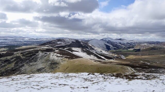
Allermuir Hill, 493m, is the closest Marilyn to central Edinburgh — the NT-prefix summit immediately above Swanston and Hillend. The toposcope on top names a view that reaches from Bass Rock to Ben Lomond.
Quick facts
- Height
- 493m/ 1617ft
- Prominence
- 236 m
- Grid ref
- NT 22705 66170
- Nearest city
- Edinburgh· 8km
- Dogs
- Dogs on lead required near livestockDog-friendly guide ↗
Height and prominence cross-checked against the Database of British and Irish Hills (CC BY).
No GPX track yet
Walked this route? Share your track to help other walkers.
Standard route
grass moorland 60% · heather 25% · rocky summit 15%
From Swanston village a path rises through the golf course onto the open hillside, then climbs the steep grassy nose to the Iron Age fort and trig. Around 6km return, 2 hours.
Terrain
Surfaced suburban paths from Swanston, then short Pentlands turf and a stony summit ring above the ancient hillfort earthworks.
In winter
Snow on Allermuir is photogenic and short-lived — the city heat plume usually clears the southern slopes within days, though the steep north face holds icy patches.
Best time of year
Getting there
- Glasgow3h 37m
- Edinburgh0h 12m
OS maps: OS Landranger 66, OS Explorer 344, OS Explorer 350
Mobile signal: Good. Pentland Hills/Edinburgh; EE excellent.
Current conditions
Daylight Today
- Sunrise
- 05:13
- Sunset
- 21:25
- Civil dawn
- 04:24
- Civil dusk
- 22:15
NOAA Solar Calculator · 30 July 2026
Pair with
Curated multi-hill combinations from Allermuir Hill.
Around Allermuir Hill on the SCOT network
Getting there, basing yourself, and what to do off the hill.
Allermuir Hill — common questions
- How hard is Allermuir Hill?
- We grade Allermuir Hill at 1/5, which puts it in easy territory. Terrain: Surfaced suburban paths from Swanston, then short Pentlands turf and a stony summit ring above the ancient hillfort earthworks.
- How prominent is Allermuir Hill?
- Allermuir Hill has 236m of topographic prominence — the height of its summit above the highest col connecting it to higher ground. Marilyns are defined by that measure: at least 150m of drop on all sides.
- When should I climb Allermuir Hill?
- The standard good-weather months for Allermuir Hill are March, April, May, June, July, August, September, October. Outside those months, expect winter conditions on the high ground — full mountain kit, navigation skills, and a check of the SAIS avalanche forecast for the relevant region.
- Can I bring my dog up Allermuir Hill?
- On a lead only — the route crosses ground with livestock or nesting-bird interest.
- What's mobile reception like on Allermuir Hill?
- Good. Pentland Hills/Edinburgh; EE excellent.
- Is Allermuir Hill safe in winter?
- Snow on Allermuir is photogenic and short-lived — the city heat plume usually clears the southern slopes within days, though the steep north face holds icy patches.
Get the OutdoorSCOT weekly
One email a week — new route, hill and bothy guides, seasonal conditions and the odd hard-won lesson. No spam, unsubscribe in one click.