Long distance
Fife Coastal Path
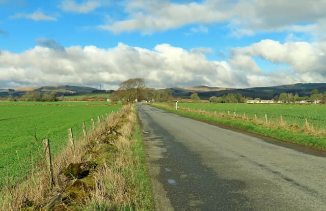
Follows the Fife coastline from the Forth Bridges around the East Neuk to the Tay Estuary. Gentle, coastal and refreshingly people-friendly. The terrain is gentle and almost entirely coastal — beaches, harbour walls, cliff paths and the occasional dune crossing — and it suits gentle multi-day walking with a strong food and history theme.
Quick facts
- Distance
- 187 km/ 117 mi
- Typical days
- 8
- Total ascent
- 2400 m
- Difficulty
- easy
- Start → Finish
- Kincardine → Newburgh
- Best direction
- West to East
- Water sources
- Continuous water — every coastal town and village along the route has taps, pubs and cafes. Kincardine, Aberdour, Burntisland, Kirkcaldy, Anstruther, Crail, St Andrews, Tayport. Never more than 3km from a refill.
- Mobile signal
- EE/Vodafone/O2 strong throughout — Fife's coastal corridor has continuous population. Reliable signal at every overnight stop and along the open beach sections.
✔ Waymarked throughout
Approximate profile derived from per-stage ascent — accurate on total climb and pattern, not a pixel-precise GPX trace.
Our take
The Fife Coastal Path is the easiest of the long-distance trails for actual walking — low-level, well-signed, and with a pub/cafe in every village. The East Neuk stretch (Elie, Anstruther, Crail, St Andrews) is the star of the show. Brilliant for a weekend chunk rather than a through-hike.
Highlights
- The Forth Bridges approach
- Elie, Anstruther and the East Neuk villages
- St Andrews
- Tentsmuir Forest
Day-by-day itinerary
A suggested 8-day schedule. Adjust to your fitness and conditions.
1Kincardine to Aberdour25km · 300m ascent
From the Kincardine Bridge east along the Forth shore past Culross, Scotland's best-preserved 17th-century village, to the beach at Aberdour.
- Terrain
- Coastal paths, village streets, some road walking.
- Overnight
- Aberdour has B&Bs and the Cedar Inn. Aberdour Silver Sands beach.
- Stats
- Kincardine → Aberdour · 25km · ↑300m
2Aberdour to Kirkcaldy24km · 250m ascent
Past Burntisland and Kinghorn with views across the Forth to Edinburgh. The coast becomes more urban approaching Kirkcaldy.
- Terrain
- Beach walking, promenade, some cliff paths.
- Overnight
- Kirkcaldy has hotels and B&Bs. Good resupply with full shops.
- Stats
- Aberdour → Kirkcaldy · 24km · ↑250m
3Kirkcaldy to Leven22km · 200m ascent
Through East Wemyss with its famous caves and along the coast to the seaside town of Leven. The Wemyss Caves have Pictish carvings.
- Terrain
- Coastal paths, promenade walking, beach sections.
- Overnight
- Leven has B&Bs and is close to Lundin Links and Lower Largo.
- Stats
- Kirkcaldy → Leven · 22km · ↑200m
4Leven to Anstruther22km · 300m ascent
Into the East Neuk — the finest stretch. Through Elie with its chain walk, past St Monans and Pittenweem to Anstruther, home of the best fish and chips in Scotland.
- Terrain
- Rocky coastal paths, harbour walks, the Elie chain walk.
- Overnight
- Anstruther has B&Bs and hotels. The Anstruther Fish Bar is essential.
- Stats
- Leven → Anstruther · 22km · ↑300m
5Anstruther to St Andrews24km · 350m ascent
Through Crail, the prettiest of the East Neuk villages, and along the cliffs past Fife Ness to the university town of St Andrews.
- Terrain
- Coastal paths, cliff-top walking, beach approach to St Andrews.
- Overnight
- St Andrews has ample hotels and B&Bs. Worth a rest day to explore.
- Stats
- Anstruther → St Andrews · 24km · ↑350m
6St Andrews to Leuchars18km · 150m ascent
Along the West Sands beach made famous by Chariots of Fire, then through the Eden Estuary nature reserve to Leuchars.
- Terrain
- Beach walking, estuary paths, flat farmland.
- Overnight
- Leuchars has B&Bs. Guard Bridge is nearby.
- Stats
- St Andrews → Leuchars · 18km · ↑150m
7Leuchars to Tayport22km · 200m ascent
Through Tentsmuir Forest — one of the finest coastal forests in Scotland — with red squirrels and roe deer, then along the Tay shore to Tayport.
- Terrain
- Forest trails, beach walking, riverside paths.
- Overnight
- Tayport has B&Bs and pubs. Views across the Tay to Dundee.
- Stats
- Leuchars → Tayport · 22km · ↑200m
8Tayport to Newburgh30km · 350m ascent
The final stretch follows the Tay Estuary west through Balmerino and past Lindores Abbey to Newburgh. The riverside walking is peaceful and satisfying.
- Terrain
- Riverside paths, farmland tracks, some road walking.
- Overnight
- Newburgh has the Abbey Inn and B&Bs. Good bus connections to Perth.
- Stats
- Tayport → Newburgh · 30km · ↑350m
Transport
To start (Kincardine)
Bus · Stagecoach East Scotland X24 / X27
Glasgow / Dunfermline to Kincardine
Up to every 30 min on the Dunfermline link
Check times & book →Train · ScotRail
Edinburgh to Dunfermline Town, then bus to Kincardine
Half-hourly to Dunfermline
Check times & book →
From finish (Newburgh)
Bus · Stagecoach East Scotland 65
Newburgh to Perth (then onward rail / bus to Edinburgh / Glasgow / Dundee)
Several daily
Check times & book →Train · ScotRail
Perth or Ladybank (8 miles from Newburgh) to Edinburgh / Glasgow / Dundee
Hourly+
Check times & book →
Best months
Accommodation
Well-served by B&Bs and hotels. Ample choice in St Andrews and the East Neuk villages. B&Bs, small hotels and a SYHA hostel at St Andrews cover the route well; book the East Neuk and St Andrews months ahead in summer as they fill up with golf tourism.
Night-by-night guide: where to stay →Resupply
Shops, pubs and cafes every few kilometres. Easiest resupply of any Scottish long-distance route. Co-op and small Tesco branches in Kirkcaldy, Anstruther, Crail, St Andrews and Tayport; no resupply gap exceeds 10km and cafes and pubs are constant along the route.
Connect with
Chain into a longer expedition by combining with adjacent long-distance routes.
Current conditions
Weather at the start point (Kincardine)
Daylight Today
- Sunrise
- 04:52
- Sunset
- 21:50
- Civil dawn
- 03:57
- Civil dusk
- 22:45
NOAA Solar Calculator · 17 July 2026
Share your experience
Walked the Fife Coastal Path? Help others plan their trip.
Getting to and from the Fife Coastal Path
Train and town anchors at each end of the route — on TripSCOT.