Sub-Marilyn · Knoydart
Sgurr Beag
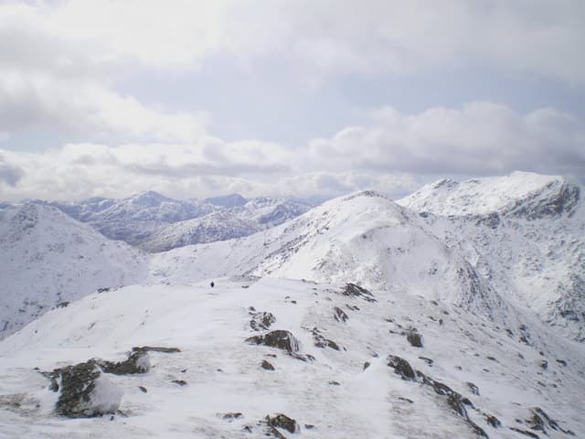
Sgurr Beag — the small peak, in a landscape where 890m is regarded as small — is a Corbett-height Marilyn on the wild ridge between Loch Quoich and Loch Nevis in inner Knoydart. The drop into the Mam Meadail to the west is one of the most striking in mainland Scotland.
Gaelic: “sharp peak, small” · Pronunciation: skoor bek
Quick facts
- Height
- 890m/ 2920ft
- Prominence
- 143 m
- Grid ref
- NM 95931 97088
- Nearest city
- Fort William· 27km
- Dogs
- Dogs on lead required near livestockDog-friendly guide ↗
Sub-Marilyn: 143m of drop — misses the 150m Marilyn cut by 7m. We keep it on the list as a near-miss.
Height and prominence cross-checked against the Database of British and Irish Hills (CC BY).
No GPX track yet
Walked this route? Share your track to help other walkers.
Standard route
heather moorland 50% · rocky slopes 35% · grass slopes 15%
Reached either by the ferry to Inverie on Loch Nevis or from the dam at the head of Loch Quoich. From Inverie a long walk up Glen Meadail and then a hard pull up the ridge to the cairn; expect 8 to 10 hours from sea level. From Quoich, a shorter but pathless approach over Sgurr nan Eugallt.
Terrain
Steep heather and bracken low down on the Inverie side, becoming Moine schist slabs and short rocky steps above 600m. The summit ridge is narrow with some scrambling depending on line; in the wet the rock is greasy.
In winter
A serious winter undertaking at 890m. Heavy Atlantic snowfall builds cornices on the eastern lip of the ridge and the long approach in short December days is unforgiving. Full winter kit and a confident party only; better as a long spring outing with a base at Inverie.
Best time of year
Getting there
- Glasgow4h 9m
- Edinburgh6h 16m
Ferry access
Mallaig → Inverie (Knoydart)
- Crossing time45 min
- Summer sailingsMon–Sat, 2–3 sailings daily (Apr–Oct, Western Isles Cruises)
- Winter sailingsMon/Wed/Fri only (Nov–Mar)
- Book ahead3 days
- Last ferry backLast ferry from Inverie ~17:30 (check Western Isles Cruises timetable)
Knoydart is a roadless peninsula — not an island, but accessible only by ferry or a very long walk (18+ km over difficult terrain). Day trips to Sgùrr Coire Choinnichean are achievable in summer. For Ladhar Bheinn, base yourself overnight at Inverie.
Book on ferry operator ↗OS maps: OS Landranger 33, OS Landranger 40, OS Explorer 398E
Mobile signal: Very poor. The Knoydart interior is one of the largest mobile dead zones in Britain; take a PLB.
Current conditions
Daylight Today
- Sunrise
- 05:16
- Sunset
- 21:40
- Civil dawn
- 04:24
- Civil dusk
- 22:32
NOAA Solar Calculator · 30 July 2026
Around Sgurr Beag on the SCOT network
Getting there, basing yourself, and what to do off the hill.
Getting there: Glenfinnan station
Glenfinnan Viaduct; Streap, Sgurr Thuilm, Glen Finnan Munros
17km from the hill
tripscot.co.uk
On TripSCOTBase yourself in Fort William
Ben Nevis base, West Highland Line, gateway to Lochaber
27km from the hill
tripscot.co.uk
On TasteSCOTAfter the hill: Ben Nevis Distillery
Fort William — Lochaber distillery at the foot of the Ben; long-aged Japanese-owned classics
27km from the hill
tastescot.co.uk
Sgurr Beag — common questions
- Is Sgurr Beag a hard climb?
- Sgurr Beag is rated 3/5 (moderately challenging) on the OutdoorSCOT scale. Underfoot: Steep heather and bracken low down on the Inverie side, becoming Moine schist slabs and short rocky steps above 600m.
- What is Sgurr Beag's prominence?
- 143m of prominence. That's the vertical drop from the summit to the col that links Sgurr Beag to the next higher ground. That leaves it 7m short of the 150m drop a Marilyn needs — DoBIH classes it a sub-Marilyn, a near-miss rather than a full Marilyn.
- When is the best time to climb Sgurr Beag?
- April, May, June, September give the most reliable conditions on Sgurr Beag. Beyond that window the high ground turns wintry: carry full mountain kit, be confident navigating, and check the SAIS avalanche forecast for the area.
- Is Sgurr Beag dog-friendly?
- Yes, but dogs must be kept on a lead — there is livestock or ground-nesting bird interest on the route.
- Is there mobile signal on Sgurr Beag?
- Very poor. The Knoydart interior is one of the largest mobile dead zones in Britain; take a PLB.
- How do I get the ferry to Sgurr Beag?
- Mallaig → Inverie (Knoydart). Mon–Sat, 2–3 sailings daily (Apr–Oct, Western Isles Cruises) in summer; Mon/Wed/Fri only (Nov–Mar) in winter. Book at least 3 days ahead. Knoydart is a roadless peninsula — not an island, but accessible only by ferry or a very long walk (18+ km over difficult terrain). Day trips to Sgùrr Coire Choinnichean are achievable in summer. For Ladhar Bheinn, base yourself overnight at Inverie.
- Is Sgurr Beag safe in winter?
- A serious winter undertaking at 890m. Heavy Atlantic snowfall builds cornices on the eastern lip of the ridge and the long approach in short December days is unforgiving. Full winter kit and a confident party only; better as a long spring outing with a base at Inverie.
Get the OutdoorSCOT weekly
One email a week — new route, hill and bothy guides, seasonal conditions and the odd hard-won lesson. No spam, unsubscribe in one click.