Sub-Marilyn · Glen Coe & Lochaber
Beinn Gharbh
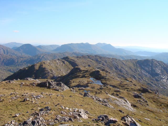
Beinn Gharbh — the rough hill — earns its name on the rocky ridge between Glenfinnan and Glen Pean north of Loch Eil. At 895m it is Corbett-height and a serious day, with the Sunart and Moidart hills laid out to the south.
Gaelic: “mountain, rough” · Pronunciation: bine yarrav
Quick facts
- Height
- 895.3m/ 2937ft
- Prominence
- 150 m
- Grid ref
- NM 88209 87650
- Nearest city
- Fort William· 26km
- Dogs
- Dogs on lead required near livestockDog-friendly guide ↗
Sub-Marilyn: the drop rounds to 150m, but DoBIH measures it a fraction under the Marilyn cut. We keep it on the list as a near-miss.
Height and prominence cross-checked against the Database of British and Irish Hills (CC BY).
No GPX track yet
Walked this route? Share your track to help other walkers.
Standard route
heather moorland 50% · rocky slopes 35% · grass slopes 15%
Most parties start from the West Highland Line at Glenfinnan station, taking the estate track up Gleann Fionn-lighe and then breaking north onto the south ridge. A long pull up rough heather and rock to a craggy summit. Allow 7 to 8 hours.
Terrain
Lower slopes are tussock and bracken; above 500m the hill turns to broken Moine schist with frequent small outcrops. The summit area is a jumble of blocks rather than a clean ridge — slow underfoot in any conditions.
In winter
A genuine winter peak at 895m above the Atlantic-facing glens of Lochaber. Heavy snowfalls and rapid freeze-thaws are typical; the summit jumble of rock catches ice readily. Full winter gear from December to March; the south ridge is the safer line in soft snow.
This hill is in the Glen Coe SAIS forecast area. Check SAIS forecasts in winter (December–April).
Best time of year
Getting there
- Glasgow4h 13m
- Edinburgh6h 27m
OS maps: OS Landranger 40, OS Explorer 398E
Mobile signal: Poor. Glenfinnan station has signal; once into Gleann Fionn-lighe it disappears for the rest of the day.
Current conditions
Daylight Today
- Sunrise
- 05:17
- Sunset
- 21:40
- Civil dawn
- 04:25
- Civil dusk
- 22:32
NOAA Solar Calculator · 30 July 2026
Around Beinn Gharbh on the SCOT network
Getting there, basing yourself, and what to do off the hill.
Base yourself in Mallaig
Ferry port for Skye and the Small Isles; CWT finish supply
22km from the hill
tripscot.co.uk
On TasteSCOTAfter the hill: Ben Nevis Distillery
Fort William — Lochaber distillery at the foot of the Ben; long-aged Japanese-owned classics
27km from the hill
tastescot.co.uk
Beinn Gharbh — common questions
- How hard is Beinn Gharbh?
- We grade Beinn Gharbh at 3/5, which puts it in moderately challenging territory. Underfoot: Lower slopes are tussock and bracken; above 500m the hill turns to broken Moine schist with frequent small outcrops.
- What is Beinn Gharbh's prominence?
- 150m of prominence. That's the vertical drop from the summit to the col that links Beinn Gharbh to the next higher ground. That rounds to 150m, but DoBIH measures the drop a fraction under the Marilyn threshold — it's classed a sub-Marilyn, a near-miss rather than a full Marilyn.
- When is the best time to climb Beinn Gharbh?
- April, May, June, September give the most reliable conditions on Beinn Gharbh. Beyond that window the high ground turns wintry: carry full mountain kit, be confident navigating, and check the SAIS avalanche forecast for the area.
- Is Beinn Gharbh dog-friendly?
- Yes, but dogs must be kept on a lead — there is livestock or ground-nesting bird interest on the route.
- Is there mobile signal on Beinn Gharbh?
- Poor. Glenfinnan station has signal; once into Gleann Fionn-lighe it disappears for the rest of the day.
- Is Beinn Gharbh safe in winter?
- A genuine winter peak at 895m above the Atlantic-facing glens of Lochaber. Heavy snowfalls and rapid freeze-thaws are typical; the summit jumble of rock catches ice readily. Full winter gear from December to March; the south ridge is the safer line in soft snow.
Get the OutdoorSCOT weekly
One email a week — new route, hill and bothy guides, seasonal conditions and the odd hard-won lesson. No spam, unsubscribe in one click.