Marilyn · Borders
North Berwick Law
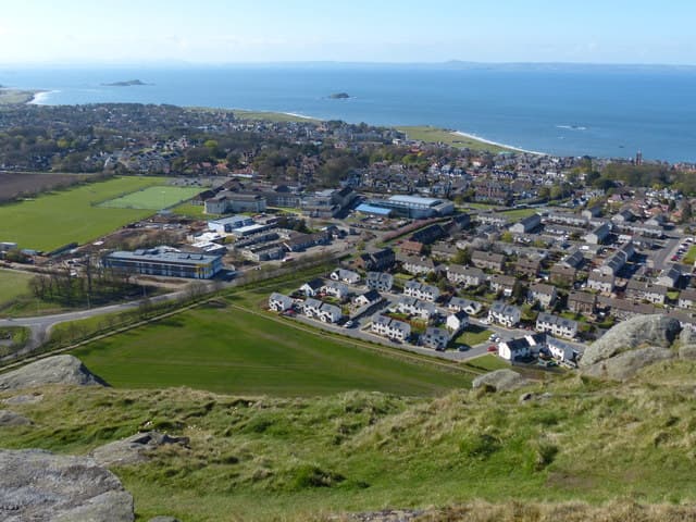
The unmistakable conical phonolite plug rising 187m straight out of the East Lothian coastal plain. A whale jawbone arch (a fibreglass replica of the original) crowns the summit, with panoramic views over the Bass Rock, Fidra and the Firth of Forth.
Quick facts
- Height
- 187m/ 614ft
- Prominence
- 168 m
- Grid ref
- NT 55639 84220
- Parking
- NT 55600 84000
- Nearest city
- Edinburgh· 31km
- Dogs
- Dogs on lead required near livestockDog-friendly guide ↗
Height and prominence cross-checked against the Database of British and Irish Hills (CC BY).
No GPX track yet
Walked this route? Share your track to help other walkers.
Standard route
volcanic rock 55% · grass slopes 35% · rocky summit 10%
A short waymarked route climbs from the car park at the south end of the Law (off the B1347), zig-zagging up the grassy western flank to reach the summit in 20-30 minutes. The descent can be made the same way or via the slightly steeper eastern path.
Terrain
Short coastal grass on the lower slopes giving way to bare phonolite rock near the top. Path well-worn and easy to follow but loose stones underfoot near the summit.
In winter
Low elevation and proximity to the sea mean snow rarely settles for long. The summit rocks can be slippery in frost — take care on the final approach.
Best time of year
Getting there
- Glasgow4h 0m
- Edinburgh1h 15m
OS maps: OS Landranger 66, OS Explorer 351E
Mobile signal: Excellent. East Lothian coast; EE reliable.
Current conditions
Daylight Today
- Sunrise
- 06:40
- Sunset
- 19:33
- Civil dawn
- 06:02
- Civil dusk
- 20:11
NOAA Solar Calculator · 14 September 2026
Around North Berwick Law on the SCOT network
Getting there, basing yourself, and what to do off the hill.
North Berwick Law — common questions
- What difficulty is North Berwick Law?
- On the OutdoorSCOT scale, North Berwick Law comes in at 1/5 — easy. Underfoot: Short coastal grass on the lower slopes giving way to bare phonolite rock near the top.
- What is North Berwick Law's prominence?
- 168m of prominence. That's the vertical drop from the summit to the col that links North Berwick Law to the next higher ground. That drop is what qualifies it as a Marilyn — a hill with at least 150m of descent on every side.
- Where do I park for North Berwick Law?
- Most walkers start from NT 55600 84000. Verify the grid reference on an OS map before you set off — space is tight on busy summer weekends.
- When is the best time to climb North Berwick Law?
- most of the year give the most reliable conditions on North Berwick Law. Beyond that window the high ground turns wintry: carry full mountain kit, be confident navigating, and check the SAIS avalanche forecast for the area.
- Is North Berwick Law dog-friendly?
- Yes, but dogs must be kept on a lead — there is livestock or ground-nesting bird interest on the route.
- Is there mobile signal on North Berwick Law?
- Excellent. East Lothian coast; EE reliable.
- Is North Berwick Law safe in winter?
- Low elevation and proximity to the sea mean snow rarely settles for long. The summit rocks can be slippery in frost — take care on the final approach.
Get the OutdoorSCOT weekly
One email a week — new route, hill and bothy guides, seasonal conditions and the odd hard-won lesson. No spam, unsubscribe in one click.