Marilyn · Outer Hebrides
Guaineamol
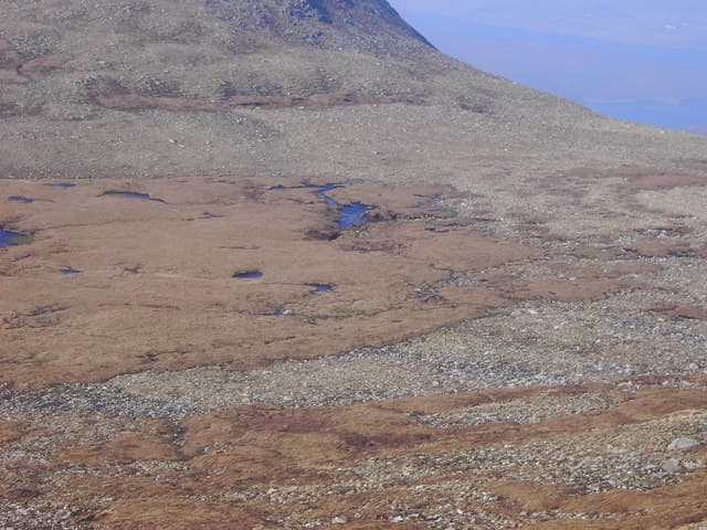
Guaineamol is a 405m gneiss summit close to Muaitheabhal in the Pairc forest, its rounded crown studded with the slabs and small tarns characteristic of the peninsula. Few walkers visit, so the sense of solitude is profound.
Quick facts
- Height
- 405.2m/ 1329ft
- Prominence
- 167 m
- Grid ref
- NB 26052 13384
- Dogs
- Dogs on lead required near livestockDog-friendly guide ↗
Height and prominence cross-checked against the Database of British and Irish Hills (CC BY).
No GPX track yet
Walked this route? Share your track to help other walkers.
Standard route
blanket bog 50% · Lewisian gneiss 35% · rocky summit 15%
Most commonly bagged as a pair with Muaitheabhal, adding 1-2 hours and a few extra kilometres to an already long Pairc day. Allow 8-10 hours for the combined round from the B8060.
Terrain
Slabby gneiss and tussock with frequent peat pools; navigation across the broad plateau between the twin tops is awkward in cloud. Boots quickly fill on wet days.
In winter
Distance and trackless ground are the limiting factors. Pick a settled spell with good visibility; the route is essentially unfeasible after a long wet spell.
Best time of year
Getting there
- Glasgow8h 21m
- Edinburgh10h 25m
Ferry access
Uig (Skye) → Tarbert (Harris)
- Crossing time105 min
- Summer sailings2 sailings daily (Apr–Oct)
- Winter sailings1 sailing daily (Nov–Mar)
- Book ahead14 days
- Last ferry backCheck CalMac timetable — last sailing to Uig varies seasonally
Drive to Uig on Skye (Skye Bridge from Kyle of Lochalsh), then ferry to Harris. Alternative: Ullapool → Stornoway (Lewis, 2h45) and drive south.
Book on CalMac ↗OS maps: OS Landranger 13, OS Landranger 14, OS Explorer 457
Mobile signal: Poor. All major carriers fail on this isolated Lewis summit.
Current conditions
Daylight Today
- Sunrise
- 05:15
- Sunset
- 21:51
- Civil dawn
- 04:20
- Civil dusk
- 22:46
NOAA Solar Calculator · 30 July 2026
Around Guaineamol on the SCOT network
Getting there, basing yourself, and what to do off the hill.
Guaineamol — common questions
- What difficulty is Guaineamol?
- On the OutdoorSCOT scale, Guaineamol comes in at 2/5 — moderate. Ground conditions: Slabby gneiss and tussock with frequent peat pools; navigation across the broad plateau between the twin tops is awkward in cloud.
- How much drop does Guaineamol have?
- The drop is 167m: measured from the summit of Guaineamol down to the saddle joining it to higher terrain. Passing the 150m-drop threshold on all sides is exactly what makes it a Marilyn.
- What's the best month to climb Guaineamol?
- Aim for April, May, June, July, August on Guaineamol. In the remaining months treat it as a winter hill — full kit, solid navigation, and a look at the relevant SAIS avalanche forecast before you go.
- Can dogs go up Guaineamol?
- Dogs are fine on a lead. The route passes livestock or ground-nesting bird habitat, so keep them close throughout.
- Will I get phone signal on Guaineamol?
- Poor. All major carriers fail on this isolated Lewis summit.
- How do I get the ferry to Guaineamol?
- Uig (Skye) → Tarbert (Harris). 2 sailings daily (Apr–Oct) in summer; 1 sailing daily (Nov–Mar) in winter. Book at least 14 days ahead. Drive to Uig on Skye (Skye Bridge from Kyle of Lochalsh), then ferry to Harris. Alternative: Ullapool → Stornoway (Lewis, 2h45) and drive south.
- Is Guaineamol safe in winter?
- Distance and trackless ground are the limiting factors. Pick a settled spell with good visibility; the route is essentially unfeasible after a long wet spell.
Get the OutdoorSCOT weekly
One email a week — new route, hill and bothy guides, seasonal conditions and the odd hard-won lesson. No spam, unsubscribe in one click.