Marilyn · North-West Highlands
Creag an Amalaidh
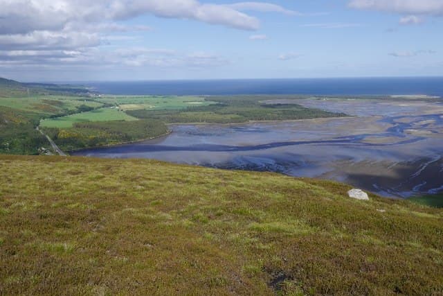
Creag an Amalaidh — sometimes anglicised as Ord Hill — rises directly above the village of Skelbo and the tidal flats of Loch Fleet, just inland from Dornoch. The NH grid puts it on the south Sutherland coast where Old Red Sandstone meets ancient gneiss, giving the hill its characteristic forested flanks and bare upper crag.
Quick facts
- Height
- 260.9m/ 856ft
- Prominence
- 154 m
- Grid ref
- NH 75880 97508
- Nearest city
- Inverness· 53km
- Dogs
- Dogs on lead required near livestockDog-friendly guide ↗
Height and prominence cross-checked against the Database of British and Irish Hills (CC BY).
No GPX track yet
Walked this route? Share your track to help other walkers.
Standard route
heather moorland 50% · rocky slopes 35% · grass slopes 15%
A waymarked Forestry and Land Scotland path climbs from the picnic area at Balblair Wood (NH 75 95) through pine plantation onto open heather and the rocky top. A short scramble onto the summit slab is rewarded with a panorama of the firth, Tarbat Ness and the Sutherland mountains. Around 5 km return with 230m of climb.
Terrain
Forest tracks on the lower half give way to a thinner peaty path through heather, with the summit reached over slabby sandstone outcrops. The forest tracks can be muddy after rain but the upper section drains well.
In winter
A genuinely low-level hill that stays out of snow for most winters. After hard frost the slabs near the cairn glaze quickly and require care, but the forest paths usually remain accessible year-round.
This hill is in the Torridon SAIS forecast area. Check SAIS forecasts in winter (December–April).
Best time of year
Getting there
- Glasgow5h 25m
- Edinburgh6h 41m
OS maps: OS Landranger 21, OS Explorer 441E
Mobile signal: Very poor. Remote Sutherland—no signal on any network. Satellite tracker advised.
Current conditions
Daylight Today
- Sunrise
- 05:05
- Sunset
- 21:40
- Civil dawn
- 04:11
- Civil dusk
- 22:35
NOAA Solar Calculator · 30 July 2026
Around Creag an Amalaidh on the SCOT network
Getting there, basing yourself, and what to do off the hill.
Creag an Amalaidh — common questions
- What difficulty is Creag an Amalaidh?
- On the OutdoorSCOT scale, Creag an Amalaidh comes in at 1/5 — easy. Terrain: Forest tracks on the lower half give way to a thinner peaty path through heather, with the summit reached over slabby sandstone outcrops.
- How prominent is Creag an Amalaidh?
- Creag an Amalaidh has 154m of topographic prominence — the height of its summit above the highest col connecting it to higher ground. Marilyns are defined by that measure: at least 150m of drop on all sides.
- When should I climb Creag an Amalaidh?
- The standard good-weather months for Creag an Amalaidh are March, April, May, June, July, August, September, October. Outside those months, expect winter conditions on the high ground — full mountain kit, navigation skills, and a check of the SAIS avalanche forecast for the relevant region.
- Can I bring my dog up Creag an Amalaidh?
- On a lead only — the route crosses ground with livestock or nesting-bird interest.
- What's mobile reception like on Creag an Amalaidh?
- Very poor. Remote Sutherland—no signal on any network. Satellite tracker advised.
- Is Creag an Amalaidh safe in winter?
- A genuinely low-level hill that stays out of snow for most winters. After hard frost the slabs near the cairn glaze quickly and require care, but the forest paths usually remain accessible year-round.
Get the OutdoorSCOT weekly
One email a week — new route, hill and bothy guides, seasonal conditions and the odd hard-won lesson. No spam, unsubscribe in one click.