Marilyn · North-West Highlands
Cnoc Mor
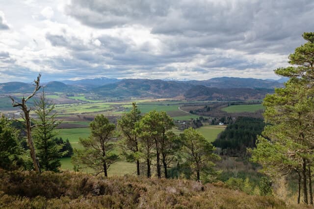
Cnoc Mor — the big knoll — rises modestly to 269m at NH 490 569 above the Black Isle, looking north-west to the Cromarty Firth. The Gaelic name is common but appropriate here — the hill stands clear of its low surroundings and its prominence is what qualifies it as a Marilyn.
Gaelic: “small hill, big” · Pronunciation: k-nok more
Quick facts
- Height
- 269m/ 883ft
- Prominence
- 161 m
- Grid ref
- NH 49028 56945
- Nearest city
- Inverness· 21km
- Dogs
- Dogs on lead required near livestockDog-friendly guide ↗
Height and prominence cross-checked against the Database of British and Irish Hills (CC BY).
No GPX track yet
Walked this route? Share your track to help other walkers.
Standard route
heather and bog 65% · grass slopes 25% · rocky summit 10%
From the B9163 near Culbokie, a forestry track climbs through commercial spruce to within 200m of the summit. A short final scramble through felled ground brings you to a small cairn. About 1.5-2 hours.
Terrain
Old Red Sandstone covered by glacial till and a mix of commercial forestry and heather. Recent felling has opened views but left rough ground; the summit knoll itself is a small heather patch surrounded by stumps.
In winter
Below 300m and close to the Moray Firth, snow is occasional and brief. The forestry shelter makes this a useful walk on windy days; the recent clear-fell is exposed but only for the last few minutes.
This hill is in the Torridon SAIS forecast area. Check SAIS forecasts in winter (December–April).
Best time of year
Getting there
- Glasgow5h 30m
- Edinburgh5h 27m
OS maps: OS Landranger 26, OS Explorer 437S
Mobile signal: Poor. No signal. The far north coast area has almost no coverage inland.
Current conditions
Daylight Today
- Sunrise
- 05:09
- Sunset
- 21:40
- Civil dawn
- 04:16
- Civil dusk
- 22:33
NOAA Solar Calculator · 30 July 2026
Around Cnoc Mor on the SCOT network
Getting there, basing yourself, and what to do off the hill.
Cnoc Mor — common questions
- What difficulty is Cnoc Mor?
- On the OutdoorSCOT scale, Cnoc Mor comes in at 1/5 — easy. Terrain: Old Red Sandstone covered by glacial till and a mix of commercial forestry and heather.
- How prominent is Cnoc Mor?
- Cnoc Mor has 161m of topographic prominence — the height of its summit above the highest col connecting it to higher ground. Marilyns are defined by that measure: at least 150m of drop on all sides.
- When should I climb Cnoc Mor?
- The standard good-weather months for Cnoc Mor are March, April, May, June, July, August, September, October. Outside those months, expect winter conditions on the high ground — full mountain kit, navigation skills, and a check of the SAIS avalanche forecast for the relevant region.
- Can I bring my dog up Cnoc Mor?
- On a lead only — the route crosses ground with livestock or nesting-bird interest.
- What's mobile reception like on Cnoc Mor?
- Poor. No signal. The far north coast area has almost no coverage inland.
- Is Cnoc Mor safe in winter?
- Below 300m and close to the Moray Firth, snow is occasional and brief. The forestry shelter makes this a useful walk on windy days; the recent clear-fell is exposed but only for the last few minutes.
Get the OutdoorSCOT weekly
One email a week — new route, hill and bothy guides, seasonal conditions and the odd hard-won lesson. No spam, unsubscribe in one click.