Marilyn · Outer Hebrides
Carnan
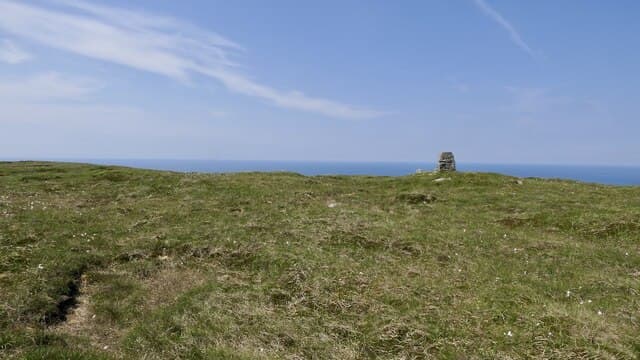
Carnan is the highest point of Mingulay, the abandoned island near the south end of the Barra chain — its village was cleared in 1912 and the island has been in National Trust for Scotland care since 2000. At 273m with full prominence, the summit rises directly behind some of the highest sea cliffs in the Hebrides, alive with puffins, razorbills and kittiwakes in early summer.
Quick facts
- Height
- 273m/ 896ft
- Prominence
- 273 m
- Grid ref
- NL 55301 82791
- Dogs
- Dogs on lead required near livestockDog-friendly guide ↗
Height and prominence cross-checked against the Database of British and Irish Hills (CC BY).
No GPX track yet
Walked this route? Share your track to help other walkers.
Standard route
grass moorland 60% · blanket bog 30% · rocky outcrops 10%
There is no scheduled service: summer boat trips run from Castlebay on Barra, landing by dinghy on the east beach when the swell allows. From the old village climb west over grass and machair to the summit ridge, keeping well back from the huge western cliff edge. Allow 2-3 hours on the island for the round trip.
Terrain
Gneiss bedrock breaks through heather and peaty grass on the climb, with patches of bog in the hollows between knolls. There is no continuous path so route-finding follows the line of least resistance up rocky steps.
In winter
Effectively unreachable in winter — the Castlebay boat trips run only in the summer season, and Atlantic swell can cancel landings even then. Plan it as a May-to-September hill.
Best time of year
Getting there
- Glasgow9h 8m
- Edinburgh12h 45m
OS maps: OS Landranger 31, OS Explorer 452S
Mobile signal: Poor to none. Uninhabited island; no reliable coverage.
Current conditions
Daylight Today
- Sunrise
- 06:59
- Sunset
- 19:54
- Civil dawn
- 06:20
- Civil dusk
- 20:32
NOAA Solar Calculator · 14 September 2026
Carnan — common questions
- Is Carnan a hard climb?
- Carnan is rated 1/5 (easy) on the OutdoorSCOT scale. Terrain: Gneiss bedrock breaks through heather and peaty grass on the climb, with patches of bog in the hollows between knolls.
- How prominent is Carnan?
- Carnan's prominence is its full height — 273m — because it is the highest point of its landmass, with no higher ground connected to it. Marilyns are defined by that measure: at least 150m of drop on all sides.
- When should I climb Carnan?
- The standard good-weather months for Carnan are May, June, July, August, September. Outside those months, expect winter conditions on the high ground — full mountain kit, navigation skills, and a check of the SAIS avalanche forecast for the relevant region.
- Can I bring my dog up Carnan?
- On a lead only — the route crosses ground with livestock or nesting-bird interest.
- What's mobile reception like on Carnan?
- Poor to none. Uninhabited island; no reliable coverage.
- Is Carnan safe in winter?
- Effectively unreachable in winter — the Castlebay boat trips run only in the summer season, and Atlantic swell can cancel landings even then. Plan it as a May-to-September hill.
Get the OutdoorSCOT weekly
One email a week — new route, hill and bothy guides, seasonal conditions and the odd hard-won lesson. No spam, unsubscribe in one click.