Marilyn · Outer Hebrides
Bioda Mor
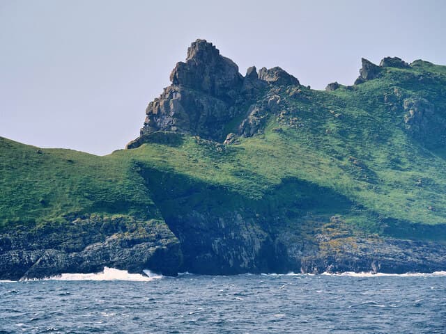
Bioda Mor — 'the big point' — rises in the NF 104 grid square at the south-west end of Dùn, the cliffed islet that shelters Hirta's Village Bay in the St Kilda group. The 178m summit caps a dramatic narrow ridge above sheer cliffs.
Gaelic: “big” · Pronunciation: bioda more
Quick facts
- Height
- 178.5m/ 586ft
- Prominence
- 179 m
- Grid ref
- NF 10427 97348
- Dogs
- Dogs on lead required near livestockDog-friendly guide ↗
Height and prominence cross-checked against the Database of British and Irish Hills (CC BY).
No GPX track yet
Walked this route? Share your track to help other walkers.
Standard route
maritime grassland 55% · rocky ridge 30% · cliff edges 15%
Reached only by dinghy or wade across the narrow channel from Hirta at low spring tides, then a steep grass scramble along the spine of Dùn. The exposed ridge requires steady nerves rather than technical climbing. Half a day on the island.
Terrain
Steeply tilted maritime grass over gabbro bedrock, with vertical drops on both sides of the ridge. Puffin burrows riddle the turf in summer and demand careful foot placement.
In winter
No winter access — the crossing from Hirta is barely possible even in calm summer conditions, let alone with autumn or winter swell running.
Best time of year
Getting there
- Glasgow12h 14m
- Edinburgh15h 42m
Ferry access
Private charter from Leverburgh (Harris) or Oban
- Crossing time180 min
- Summer sailingsNo regular service — chartered day trips and stays May–Sep only, weather dependent
- Winter sailingsNo access in winter
- Book ahead90 days
St Kilda is 64km west of the Outer Hebrides — one of the most remote places in Britain. Access by private charter boat (weather permitting) or NTS-arranged visits. Camping and bothy accommodation available; no day trips possible.
OS maps: OS Landranger 18, OS Explorer 460W
Mobile signal: None. St Kilda; no signal of any kind. Charter boat and satellite communications only.
Current conditions
Daylight Today
- Sunrise
- 05:24
- Sunset
- 21:57
- Civil dawn
- 04:30
- Civil dusk
- 22:52
NOAA Solar Calculator · 30 July 2026
Bioda Mor — common questions
- How difficult is Bioda Mor?
- Bioda Mor carries a 1/5 (easy) grade on the OutdoorSCOT scale. Terrain: Steeply tilted maritime grass over gabbro bedrock, with vertical drops on both sides of the ridge.
- How prominent is Bioda Mor?
- Bioda Mor's prominence is its full height — 179m — because it is the highest point of its landmass, with no higher ground connected to it. Marilyns are defined by that measure: at least 150m of drop on all sides.
- When should I climb Bioda Mor?
- The standard good-weather months for Bioda Mor are March, April, May, June, July, August, September, October. Outside those months, expect winter conditions on the high ground — full mountain kit, navigation skills, and a check of the SAIS avalanche forecast for the relevant region.
- Can I bring my dog up Bioda Mor?
- On a lead only — the route crosses ground with livestock or nesting-bird interest.
- What's mobile reception like on Bioda Mor?
- None. St Kilda; no signal of any kind. Charter boat and satellite communications only.
- How do I get the ferry to Bioda Mor?
- Private charter from Leverburgh (Harris) or Oban. No regular service — chartered day trips and stays May–Sep only, weather dependent in summer; No access in winter in winter. Book at least 90 days ahead. St Kilda is 64km west of the Outer Hebrides — one of the most remote places in Britain. Access by private charter boat (weather permitting) or NTS-arranged visits. Camping and bothy accommodation available; no day trips possible.
- Is Bioda Mor safe in winter?
- No winter access — the crossing from Hirta is barely possible even in calm summer conditions, let alone with autumn or winter swell running.
Get the OutdoorSCOT weekly
One email a week — new route, hill and bothy guides, seasonal conditions and the odd hard-won lesson. No spam, unsubscribe in one click.