Marilyn · Outer Hebrides
Beinn Ruigh Choinnich
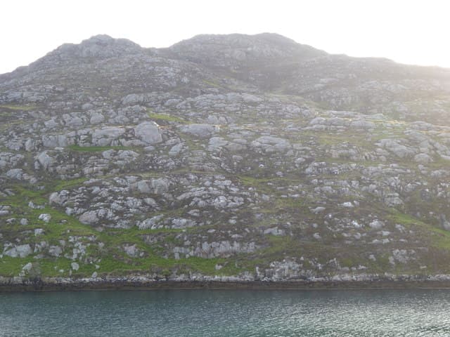
Beinn Ruigh Choinnich — Kenneth's shieling hill — looms directly above Lochboisdale and is the first peak many visitors lay eyes on when stepping off the Calmac ferry. Its 276m summit gives a fine overview of the southern Uist seascape.
Quick facts
- Height
- 276m/ 906ft
- Prominence
- 170 m
- Grid ref
- NF 80657 19675
- Dogs
- Dogs on lead required near livestockDog-friendly guide ↗
Height and prominence cross-checked against the Database of British and Irish Hills (CC BY).
No GPX track yet
Walked this route? Share your track to help other walkers.
Standard route
blanket bog 50% · Lewisian gneiss 35% · rocky summit 15%
A short, sharp climb straight from the village, ascending grass and rocky steps onto the broad ridge. Most parties reach the summit and return in under three hours, often as a leg-stretch after a long drive or sailing.
Terrain
Heather and short turf interspersed with gneiss ribs, often slippery when damp. There are sheep on the lower slopes — keep dogs leashed throughout.
In winter
Within easy reach of Lochboisdale shelter, so a useful storm-day option. Expect saturated ground rather than snow and beware of strong gusts on the open summit ridge.
Best time of year
Getting there
- Glasgow9h 32m
- Edinburgh11h 3m
Ferry access
Mallaig → Lochboisdale (South Uist)
- Crossing time210 min
- Summer sailings1–2 sailings daily (Apr–Oct)
- Winter sailingsReduced sailings on a combined Oban–Castlebay/Lochboisdale winter timetable (Nov–Mar)
- Book ahead14 days
Plan an overnight stay. Alternative: Uig (Skye) → Lochmaddy (North Uist) then drive south across the causeways.
Book on CalMac ↗OS maps: OS Landranger 31, OS Explorer 453S
Mobile signal: Poor. coverage drops during the approach; Lewisian gneiss landscape gives zero coverage.
Current conditions
Daylight Today
- Sunrise
- 05:23
- Sunset
- 21:49
- Civil dawn
- 04:30
- Civil dusk
- 22:41
NOAA Solar Calculator · 30 July 2026
Beinn Ruigh Choinnich — common questions
- What difficulty is Beinn Ruigh Choinnich?
- On the OutdoorSCOT scale, Beinn Ruigh Choinnich comes in at 1/5 — easy. Ground conditions: Heather and short turf interspersed with gneiss ribs, often slippery when damp.
- How much drop does Beinn Ruigh Choinnich have?
- The drop is 170m: measured from the summit of Beinn Ruigh Choinnich down to the saddle joining it to higher terrain. Passing the 150m-drop threshold on all sides is exactly what makes it a Marilyn.
- What's the best month to climb Beinn Ruigh Choinnich?
- Aim for March, April, May, June, July, August, September, October on Beinn Ruigh Choinnich. In the remaining months treat it as a winter hill — full kit, solid navigation, and a look at the relevant SAIS avalanche forecast before you go.
- Can dogs go up Beinn Ruigh Choinnich?
- Dogs are fine on a lead. The route passes livestock or ground-nesting bird habitat, so keep them close throughout.
- Will I get phone signal on Beinn Ruigh Choinnich?
- Poor. coverage drops during the approach; Lewisian gneiss landscape gives zero coverage.
- How do I get the ferry to Beinn Ruigh Choinnich?
- Mallaig → Lochboisdale (South Uist). 1–2 sailings daily (Apr–Oct) in summer; Reduced sailings on a combined Oban–Castlebay/Lochboisdale winter timetable (Nov–Mar) in winter. Book at least 14 days ahead. Plan an overnight stay. Alternative: Uig (Skye) → Lochmaddy (North Uist) then drive south across the causeways.
- Is Beinn Ruigh Choinnich safe in winter?
- Within easy reach of Lochboisdale shelter, so a useful storm-day option. Expect saturated ground rather than snow and beware of strong gusts on the open summit ridge.
Get the OutdoorSCOT weekly
One email a week — new route, hill and bothy guides, seasonal conditions and the odd hard-won lesson. No spam, unsubscribe in one click.