Marilyn · Argyll
Beinn Bhreac
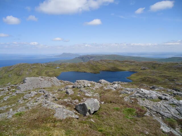
This particular Beinn Bhreac — the Speckled Hill — stands at 468m on the Craignish peninsula in mid-Argyll. Its position close to the western coast gives a remarkable seaward panorama over the Sound of Jura and Lunga.
Quick facts
- Height
- 468m/ 1535ft
- Grid ref
- NR 59760 90803
- Nearest city
- Oban· 47km
- Dogs
- Dogs on lead required near livestockDog-friendly guide ↗
No GPX track yet
Walked this route? Share your track to help other walkers.
Standard route
heather moorland 60% · grass slopes 25% · schist outcrops 15%
Park near Ardfern or Craobh Haven and follow estate tracks toward the open hill. The final ascent over short heather is fairly easy, taking around 3-4 hours in total.
Terrain
Mature woodland tracks lead onto open moor. The summit ridge is short cropped heather with several intermediate bumps to traverse.
In winter
A reasonable winter target. Sea-level start and modest height mean snow is rarely a real issue. Atlantic gales are the main consideration on the open summit.
Best time of year
Getting there
- Glasgow4h 11m
- Edinburgh7h 55m
Ferry access
Kennacraig → Port Askaig (Islay) then Port Askaig → Feolin (Jura)
- Crossing time145 min
- Summer sailingsIslay: 1–2 CalMac sailings daily. Jura ferry: frequent throughout the day
- Winter sailingsIslay: 1 CalMac sailing daily. Jura ferry: reduced but regular
- Book ahead21 days
- Last ferry backLast Jura ferry ~17:00; last Islay sailing varies — check both timetables
Two ferries required: CalMac Kennacraig → Port Askaig (2h15), then the short Jura passenger ferry (10 min) from Port Askaig to Feolin. No car needed once on Jura for the Paps.
Book on ferry operator ↗OS maps: OS Landranger 61, OS Explorer 355N
Mobile signal: Poor. Knapdale/Loch Fyne area; intermittent coverage.
Current conditions
Daylight Today
- Sunrise
- 04:39
- Sunset
- 22:14
- Civil dawn
- 03:36
- Civil dusk
- 23:17
NOAA Solar Calculator · 27 June 2026
Around Beinn Bhreac on the SCOT network
Getting there, basing yourself, and what to do off the hill.
Getting there: Oban station
Argyll ferry hub; Mull, Lismore, Coll, Tiree, Barra connections
47km from the hill
tripscot.co.uk
On TripSCOTBase yourself in Oban
Argyll ferry hub — Mull, Lismore, Coll, Tiree, Barra
47km from the hill
tripscot.co.uk
On TasteSCOTAfter the hill: Jura
Craighouse on Jura — island distillery in a single-street village
24km from the hill
tastescot.co.uk
Beinn Bhreac — common questions
- How hard is Beinn Bhreac?
- Beinn Bhreac is rated 1/5 (easy) on the OutdoorSCOT scale. Terrain: Mature woodland tracks lead onto open moor.
- When is the best time to climb Beinn Bhreac?
- The standard good-weather months for Beinn Bhreac are March, April, May, June, July, August, September, October. Outside those months, expect winter conditions on the high ground — full mountain kit, navigation skills, and a check of the SAIS avalanche forecast for the relevant region.
- Can I bring my dog up Beinn Bhreac?
- Yes, but dogs must be kept on a lead — there is livestock or ground-nesting bird interest on the route.
- Is there mobile signal on Beinn Bhreac?
- Poor. Knapdale/Loch Fyne area; intermittent coverage.
- How do I get the ferry to Beinn Bhreac?
- Kennacraig → Port Askaig (Islay) then Port Askaig → Feolin (Jura). Islay: 1–2 CalMac sailings daily. Jura ferry: frequent throughout the day in summer; Islay: 1 CalMac sailing daily. Jura ferry: reduced but regular in winter. Book at least 21 days ahead. Two ferries required: CalMac Kennacraig → Port Askaig (2h15), then the short Jura passenger ferry (10 min) from Port Askaig to Feolin. No car needed once on Jura for the Paps.
- Is Beinn Bhreac safe in winter?
- A reasonable winter target. Sea-level start and modest height mean snow is rarely a real issue. Atlantic gales are the main consideration on the open summit.
Get the OutdoorSCOT weekly
One email a week — new route, hill and bothy guides, seasonal conditions and the odd hard-won lesson. No spam, unsubscribe in one click.