Graham · Outer Hebrides
Uisgneabhal Mor (Uisgnaval Mor)
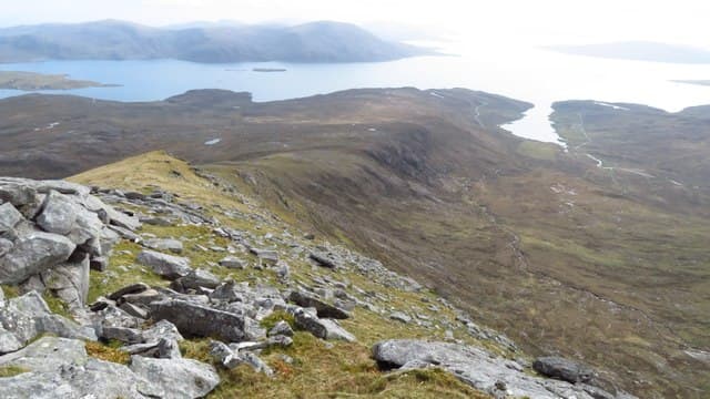
A craggy gneiss Graham at the south end of the Harris hills, looking across Loch Langavat to Clisham. The hill's name means hill of the water valley — apt for a peak surrounded by lochans and burns.
Gaelic: “big” · Pronunciation: uisgneabhal more (uisgnaval mor)
Quick facts
- Height
- 730.1m/ 2395ft
- Prominence
- 483 m
- Distance
- 13 km
- Ascent
- 599 m
- Time
- 4–6 hrs
- Grid ref
- NB120085
- Parking
- NB133089
- Nearest
- Ullapool
- Dogs
- Dogs on lead required near livestockDog-friendly guide ↗
Height and prominence cross-checked against the Database of British and Irish Hills (CC BY).
No GPX track yet
Walked this route? Share your track to help other walkers.
Standard route
island track 20% · rough gneiss 40% · rocky ridge 30% · summit area 10%
Park near Bunavoneader on the A859. Follow the old whaling station track east into Glen Ulladale, then climb the south-west spur directly. The upper ridge winds round small lochans onto the summit cairn.
Terrain
Stripped Lewisian gneiss slabs, peat hags and tussocky grass — classic Hebridean walking surface. The summit area is intricate and there are several knolls before the true top.
In winter
Snow rarely sticks at Hebridean altitudes but ice on the gneiss slabs is treacherous. The hills here catch the full force of North Atlantic gales — wind, not snow, is the season's main hazard.
Best time of year
Getting there
- Glasgow5h 27m
- Edinburgh6h 5m
Ferry access
Uig (Skye) → Tarbert (Harris)
- Crossing time105 min
- Summer sailings2 sailings daily (Apr–Oct)
- Winter sailings1 sailing daily (Nov–Mar)
- Book ahead14 days
- Last ferry backCheck CalMac timetable — last sailing to Uig varies seasonally
Drive to Uig on Skye (Skye Bridge from Kyle of Lochalsh), then ferry to Harris. Alternative: Ullapool → Stornoway (Lewis, 2h45) and drive south.
Book on CalMac ↗OS maps: OS Landranger 13, OS Landranger 14
Mobile signal: Reception on the A859; gone immediately on the hill
Current conditions
Daylight Today
- Sunrise
- 04:51
- Sunset
- 22:16
- Civil dawn
- 03:48
- Civil dusk
- 23:19
NOAA Solar Calculator · 17 July 2026
Pair with
Curated multi-hill combinations from Uisgneabhal Mor (Uisgnaval Mor).
Around Uisgneabhal Mor (Uisgnaval Mor) on the SCOT network
Getting there, basing yourself, and what to do off the hill.
Uisgneabhal Mor (Uisgnaval Mor) — common questions
- What difficulty is Uisgneabhal Mor (Uisgnaval Mor)?
- On the OutdoorSCOT scale, Uisgneabhal Mor (Uisgnaval Mor) comes in at 4/5 — challenging. Expect roughly 13km and 599m of ascent on the usual route — 4-6 hours for most parties. Underfoot: Stripped Lewisian gneiss slabs, peat hags and tussocky grass — classic Hebridean walking surface.
- What is Uisgneabhal Mor (Uisgnaval Mor)'s prominence?
- 483m of prominence. That's the vertical drop from the summit to the col that links Uisgneabhal Mor (Uisgnaval Mor) to the next higher ground.
- Where do I park for Uisgneabhal Mor (Uisgnaval Mor)?
- Most walkers start from NB133089 near Ullapool. Verify the grid reference on an OS map before you set off — space is tight on busy summer weekends.
- When is the best time to climb Uisgneabhal Mor (Uisgnaval Mor)?
- May, June, July, August, September give the most reliable conditions on Uisgneabhal Mor (Uisgnaval Mor). Beyond that window the high ground turns wintry: carry full mountain kit, be confident navigating, and check the SAIS avalanche forecast for the area.
- Is Uisgneabhal Mor (Uisgnaval Mor) dog-friendly?
- Yes, but dogs must be kept on a lead — there is livestock or ground-nesting bird interest on the route.
- Is there mobile signal on Uisgneabhal Mor (Uisgnaval Mor)?
- Reception on the A859; gone immediately on the hill
- How do I get the ferry to Uisgneabhal Mor (Uisgnaval Mor)?
- Uig (Skye) → Tarbert (Harris). 2 sailings daily (Apr–Oct) in summer; 1 sailing daily (Nov–Mar) in winter. Book at least 14 days ahead. Drive to Uig on Skye (Skye Bridge from Kyle of Lochalsh), then ferry to Harris. Alternative: Ullapool → Stornoway (Lewis, 2h45) and drive south.
- Is Uisgneabhal Mor (Uisgnaval Mor) safe in winter?
- Snow rarely sticks at Hebridean altitudes but ice on the gneiss slabs is treacherous. The hills here catch the full force of North Atlantic gales — wind, not snow, is the season's main hazard.
Get the OutdoorSCOT weekly
One email a week — new route, hill and bothy guides, seasonal conditions and the odd hard-won lesson. No spam, unsubscribe in one click.