Graham · Borders
Cauldcleuch Head
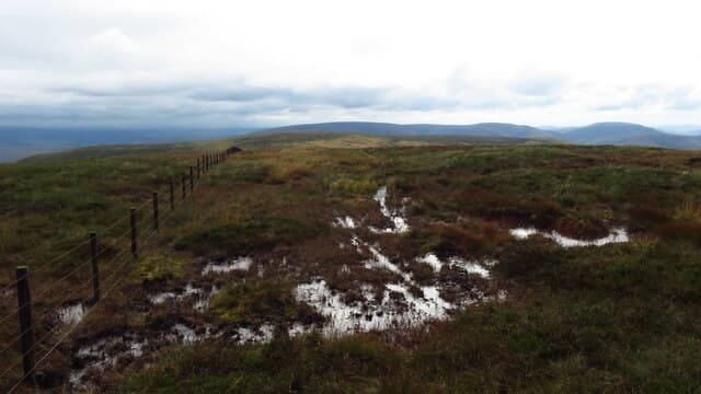
Cauldcleuch Head (618m) is the high point of the Roxburghshire-Dumfriesshire watershed in the NT45 square, between Teviotdale and Eskdale. The summit is unmarked except for a fence junction, with a clear sweep across the heart of the Southern Uplands to White Coomb, the Cheviot and on a clear day even the Solway. It is one of the more remote Border Grahams, with the road approaches from either side feeling notably empty.
Quick facts
- Height
- 618.6m/ 2030ft
- Prominence
- 256 m
- Distance
- 12 km
- Ascent
- 464 m
- Time
- 3–5 hrs
- Grid ref
- NT456006
- Parking
- NT534016
- Nearest city
- Carlisle· 45km
- Dogs
- Dogs on lead required near livestockDog-friendly guide ↗
Height and prominence cross-checked against the Database of British and Irish Hills (CC BY).
No GPX track yet
Walked this route? Share your track to help other walkers.
Standard route
grass moorland 80% · heather patches 15% · summit area 5%
From the verge parking at NT534016 on the B6399 above Hermitage, follow the burn-side track north before climbing onto the open hillside on the south flank. The fence line is the obvious handrail to the top. Allow about five hours round trip; the descent reverses the climb to avoid the steeper ground falling east into Cauldcleuch Burn.
Terrain
Short cropped grass and bilberry fill the upper hill, with tussocks and peat hags on the lower flanks. The fence is your main landmark — the summit is little more than a junction of march fences. Streams running south to the Hermitage Water can swell after rain.
In winter
The watershed catches Atlantic snow on its westerly side and easterly cold-air outbreaks from the North Sea. Drifted snow lies in the lee of the fence for weeks longer than the surrounding hills suggest. With no built shelter on the top, the hill becomes serious in any wind once snow is on the ground.
Best time of year
Getting there
- Glasgow2h 17m
- Edinburgh2h 48m
OS maps: OS Landranger 79
Mobile signal: Strong summit reception; EE and O2 reliable. Border hill with fine views.
Current conditions
Daylight Today
- Sunrise
- 04:48
- Sunset
- 21:47
- Civil dawn
- 03:53
- Civil dusk
- 22:41
NOAA Solar Calculator · 13 July 2026
Around Cauldcleuch Head on the SCOT network
Getting there, basing yourself, and what to do off the hill.
Cauldcleuch Head — common questions
- How difficult is Cauldcleuch Head?
- Cauldcleuch Head carries a 3/5 (moderately challenging) grade on the OutdoorSCOT scale. Count on about 12km, 464m of ascent and a 3-5 hour day on the standard route. Terrain: Short cropped grass and bilberry fill the upper hill, with tussocks and peat hags on the lower flanks.
- How prominent is Cauldcleuch Head?
- Cauldcleuch Head has 256m of topographic prominence — the height of its summit above the highest col connecting it to higher ground.
- Where should I park to climb Cauldcleuch Head?
- Standard parking is at NT534016. Check the parking grid reference on an OS map before travel; informal laybys can fill on summer weekends.
- When should I climb Cauldcleuch Head?
- The standard good-weather months for Cauldcleuch Head are March, April, May, June, July, August, September, October, November. Outside those months, expect winter conditions on the high ground — full mountain kit, navigation skills, and a check of the SAIS avalanche forecast for the relevant region.
- Can I bring my dog up Cauldcleuch Head?
- On a lead only — the route crosses ground with livestock or nesting-bird interest.
- What's mobile reception like on Cauldcleuch Head?
- Strong summit reception; EE and O2 reliable. Border hill with fine views.
- Is Cauldcleuch Head safe in winter?
- The watershed catches Atlantic snow on its westerly side and easterly cold-air outbreaks from the North Sea. Drifted snow lies in the lee of the fence for weeks longer than the surrounding hills suggest. With no built shelter on the top, the hill becomes serious in any wind once snow is on the ground.
Get the OutdoorSCOT weekly
One email a week — new route, hill and bothy guides, seasonal conditions and the odd hard-won lesson. No spam, unsubscribe in one click.