Graham · Argyll & Bute
Beinn Shiantaidh
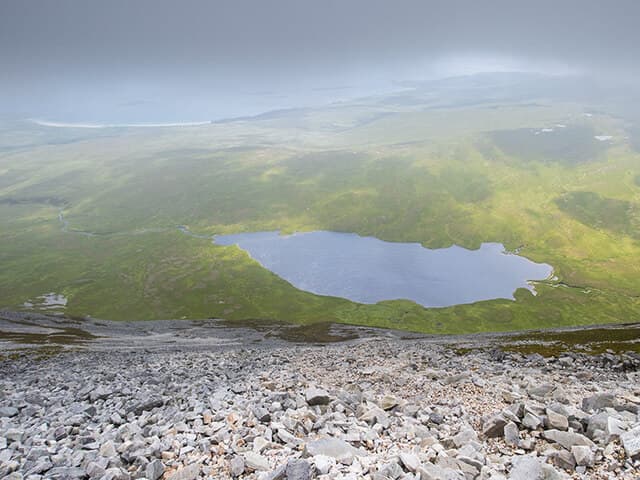
The most easterly of the three Paps of Jura, an unmistakable white quartzite cone seen from miles across the Sound of Jura. Less visited than Beinn an Oir but the classic Paps traverse needs it; alone it provides one of the most distinctive island summits in Scotland.
Quick facts
- Height
- 757.2m/ 2484ft
- Prominence
- 303 m
- Distance
- ~14 km
- Ascent
- ~621 m
- Time
- 4–7 hrs
- Grid ref
- NR513747
- Parking
- NR527759
- Nearest
- Oban
- Dogs
- Dogs on lead required near livestockDog-friendly guide ↗
Height and prominence cross-checked against the Database of British and Irish Hills (CC BY).
No GPX track yet
Walked this route? Share your track to help other walkers.
Standard route
island track 15% · rough bog 25% · quartzite scree 40% · summit rocks 20%
Start at the bridge over the Corran River on the A846 north of Craighouse. Cross the boggy moor west toward the foot of the cone, then tackle the relentless quartzite scree directly to the summit. Steep, loose, and slow.
Terrain
Bog and lochan-strewn moor on the approach, then unstable white quartzite blocks for the entire upper section. The scree is famously tiring under foot.
In winter
Snow rarely settles on Jura but rime ice on the quartzite blocks turns the scree into something close to a graded climb. Wind off the Atlantic is the deciding factor — the cone offers zero shelter.
Kit for this: the winter Munro kit list · which boots take crampons
Best time of year
Getting there
- Glasgow3h 48m
- Edinburgh4h 51m
Ferry access
Kennacraig → Port Askaig (Islay) then Port Askaig → Feolin (Jura)
- Crossing time145 min
- Summer sailingsIslay: 1–2 CalMac sailings daily. Jura ferry: frequent throughout the day
- Winter sailingsIslay: 1 CalMac sailing daily. Jura ferry: reduced but regular
- Book ahead21 days
- Last ferry backLast Jura ferry ~17:00; last Islay sailing varies — check both timetables
Two ferries required: CalMac Kennacraig → Port Askaig (2h15), then the short Jura passenger ferry (10 min) from Port Askaig to Feolin. No car needed once on Jura for the Paps.
Book on ferry operator ↗OS maps: OS Landranger 61
Mobile signal: No signal on Jura — very limited island coverage
Current conditions
Daylight Today
- Sunrise
- 07:52
- Sunset
- 18:28
- Civil dawn
- 07:15
- Civil dusk
- 19:05
NOAA Solar Calculator · 14 October 2026
Pair with
Curated multi-hill combinations from Beinn Shiantaidh.
Around Beinn Shiantaidh on the SCOT network
Getting there, basing yourself, and what to do off the hill.
Beinn Shiantaidh — common questions
- What difficulty is Beinn Shiantaidh?
- On the OutdoorSCOT scale, Beinn Shiantaidh comes in at 4/5 — challenging. Expect roughly 14km and 621m of ascent on the usual route — 4-7 hours for most parties. Ground conditions: Bog and lochan-strewn moor on the approach, then unstable white quartzite blocks for the entire upper section.
- How much drop does Beinn Shiantaidh have?
- The drop is 303m: measured from the summit of Beinn Shiantaidh down to the saddle joining it to higher terrain.
- Where's the parking for Beinn Shiantaidh?
- Park at NR527759 near Oban. Double-check the grid reference on an OS map first; informal laybys here fill early in high season.
- What's the best month to climb Beinn Shiantaidh?
- Aim for May, June, July, August, September on Beinn Shiantaidh. In the remaining months treat it as a winter hill — full kit, solid navigation, and a look at the relevant SAIS avalanche forecast before you go.
- Can dogs go up Beinn Shiantaidh?
- Dogs are fine on a lead. The route passes livestock or ground-nesting bird habitat, so keep them close throughout.
- Will I get phone signal on Beinn Shiantaidh?
- No signal on Jura — very limited island coverage
- How do I get the ferry to Beinn Shiantaidh?
- Kennacraig → Port Askaig (Islay) then Port Askaig → Feolin (Jura). Islay: 1–2 CalMac sailings daily. Jura ferry: frequent throughout the day in summer; Islay: 1 CalMac sailing daily. Jura ferry: reduced but regular in winter. Book at least 21 days ahead. Two ferries required: CalMac Kennacraig → Port Askaig (2h15), then the short Jura passenger ferry (10 min) from Port Askaig to Feolin. No car needed once on Jura for the Paps.
- Is Beinn Shiantaidh safe in winter?
- Snow rarely settles on Jura but rime ice on the quartzite blocks turns the scree into something close to a graded climb. Wind off the Atlantic is the deciding factor — the cone offers zero shelter.
Get the OutdoorSCOT weekly
One email a week — new route, hill and bothy guides, seasonal conditions and the odd hard-won lesson. No spam, unsubscribe in one click.