Corbett · Arran
Cir Mhor
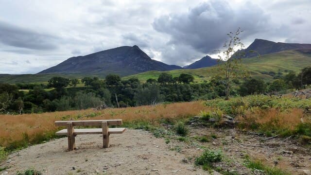
Cìr Mhòr — 'the great comb' — is the granite spike at the geometric heart of the Arran hills, widely considered the finest mountain on the island and arguably the most distinctive small peaks in Scotland. Although only 799m it is shaped like a true alp: pyramidal from every angle, with rock climbing routes on three faces (including the famous Rosa Pinnacle) and a summit barely big enough for a small group. The mountain sits at the junction of Glen Rosa, Glen Sannox and the A' Chir ridge.
Gaelic: “big” · Pronunciation: cir vore
Quick facts
- Height
- 798.1m/ 2618ft
- Prominence
- 177 m
- Distance
- 15 km
- Ascent
- 870 m
- Time
- 5–8 hrs
- Grid ref
- NR972431
- Parking
- NS001376
- Nearest city
- Glasgow· 66km
- Dogs
- Dogs on lead required near livestockDog-friendly guide ↗
Height and prominence cross-checked against the Database of British and Irish Hills (CC BY).
No GPX track yet
Walked this route? Share your track to help other walkers.
Standard route
glen path 20% · steep grass 20% · granite scramble 45% · summit pinnacle 15%
Most parties approach from Glen Rosa, parking near the bridge at the end of the public road north of Brodick (NS001376). Walk up Glen Rosa on a clear path for around 6km to the col known as the Saddle. From the Saddle, climb steeply north onto the south ridge of Cìr Mhòr and follow it to the summit. The final section involves easy scrambling. An alternative descent over the Witch's Step links to Caisteal Abhail; the full A' Chir traverse to the south is serious mountaineering. Allow 6–8 hours.
Terrain
Excellent path up Glen Rosa — well-maintained and a beautiful walk in its own right. From the Saddle upwards the terrain is steep grass and granite slab, with short scrambly steps. The summit is small and rocky with significant drops on three sides; in cloud, the descent line requires care.
In winter
Cìr Mhòr in firm winter conditions is a serious alpine-style peak — the south ridge becomes a Grade II winter route with steep snow and some short technical sections. Verglas on the granite makes the upper section treacherous. The combination of remoteness from the road, short daylight and exposed terrain means winter ascents need full mountaineering kit and judgement.
Best time of year
Getting there
- Glasgow2h 34m
- Edinburgh3h 48m
Ferry access
Ardrossan → Brodick
- Crossing time55 min
- Summer sailingsUp to 6 sailings daily (Apr–Oct)
- Winter sailings3–4 sailings daily (Nov–Mar)
- Book ahead7 days
- Last ferry backCheck CalMac timetable — last departure varies seasonally
Foot passengers welcome without booking. Book vehicle space well in advance in summer. A seasonal alternative runs Claonaig → Lochranza (30 min) in summer.
Book on CalMac ↗OS maps: OS Landranger 62, OS Landranger 69
Mobile signal: Reasonable signal at Glen Rosa road end; weakens up the glen; brief 4G on the summit given line of sight to Brodick
Current conditions
Daylight Today
- Sunrise
- 04:55
- Sunset
- 21:58
- Civil dawn
- 03:59
- Civil dusk
- 22:54
NOAA Solar Calculator · 13 July 2026
Pair with
Curated multi-hill combinations from Cir Mhor.
Around Cir Mhor on the SCOT network
Getting there, basing yourself, and what to do off the hill.
Getting there: Ardrossan Harbour station
Ferry to Brodick (Arran) — Goat Fell, Arran ridge
25km from the hill
tripscot.co.uk
On TripSCOTBase yourself in Brodick
Arran base — Goat Fell, Glen Rosa, the Arran ridge
8km from the hill
tripscot.co.uk
On TasteSCOTAfter the hill: Arran
Lochranza — northern Arran; revived in 1995; rich sherried releases
9km from the hill
tastescot.co.uk
Cir Mhor — common questions
- Is Cir Mhor a hard climb?
- Cir Mhor is rated 4/5 (challenging) on the OutdoorSCOT scale. The standard route covers about 15km with 870m of ascent and takes most walkers 5-8 hours. Ground conditions: Excellent path up Glen Rosa — well-maintained and a beautiful walk in its own right.
- How much drop does Cir Mhor have?
- The drop is 177m: measured from the summit of Cir Mhor down to the saddle joining it to higher terrain.
- Where's the parking for Cir Mhor?
- Park at NS001376. Double-check the grid reference on an OS map first; informal laybys here fill early in high season.
- What's the best month to climb Cir Mhor?
- Aim for April, May, June, July, August, September, October on Cir Mhor. In the remaining months treat it as a winter hill — full kit, solid navigation, and a look at the relevant SAIS avalanche forecast before you go.
- Can dogs go up Cir Mhor?
- Dogs are fine on a lead. The route passes livestock or ground-nesting bird habitat, so keep them close throughout.
- Will I get phone signal on Cir Mhor?
- Reasonable signal at Glen Rosa road end; weakens up the glen; brief 4G on the summit given line of sight to Brodick
- How do I get the ferry to Cir Mhor?
- Ardrossan → Brodick. Up to 6 sailings daily (Apr–Oct) in summer; 3–4 sailings daily (Nov–Mar) in winter. Book at least 7 days ahead. Foot passengers welcome without booking. Book vehicle space well in advance in summer. A seasonal alternative runs Claonaig → Lochranza (30 min) in summer.
- Is Cir Mhor safe in winter?
- Cìr Mhòr in firm winter conditions is a serious alpine-style peak — the south ridge becomes a Grade II winter route with steep snow and some short technical sections. Verglas on the granite makes the upper section treacherous. The combination of remoteness from the road, short daylight and exposed terrain means winter ascents need full mountaineering kit and judgement.
Get the OutdoorSCOT weekly
One email a week — new route, hill and bothy guides, seasonal conditions and the odd hard-won lesson. No spam, unsubscribe in one click.