Corbett · Arran
Beinn Tarsuinn
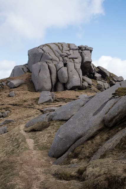
Beinn Tarsuinn — 'the transverse hill' — is the 826m Corbett standing at the heart of Arran's granite ridge, the third-highest summit on the island after Goat Fell and Caisteal Abhail. The name is apt: the hill sits crosswise between Glen Rosa and the upper basin of the western glens, with its summit ridge running north-east to south-west. From the top the view runs to Cìr Mhòr immediately to the north and along the famous A' Chir ridge to the west — perhaps the most photographed line of granite in Arran.
Quick facts
- Height
- 826m/ 2710ft
- Prominence
- 237 m
- Distance
- ~14 km
- Ascent
- ~900 m
- Time
- 4–7 hrs
- Grid ref
- NR959412
- Parking
- NS001376
- Nearest
- Glasgow· Glasgow 68km
- Dogs
- Dogs on lead required near livestockDog-friendly guide ↗
Height and prominence cross-checked against the Database of British and Irish Hills (CC BY).
No GPX track yet
Walked this route? Share your track to help other walkers.
Standard route
glen path 25% · steep grass 30% · rocky ridge 35% · summit area 10%
Start at Glen Rosa car park north of Brodick (NS001376). Walk up the Glen Rosa path for around 5km to the Saddle below Cìr Mhòr, then climb south-west onto Beinn Tarsuinn's north-east ridge. The route gains the summit cairn after a steady pull over granite slab. For the natural pairing, drop south-west to the start of the A' Chir ridge and continue toward Beinn Nuis. Allow 6–7 hours for Tarsuinn alone.
Terrain
Glen Rosa path is excellent for the first 5km. Above the Saddle the going turns to steep granite slab interspersed with grass and short scrambling steps. The summit crest is solid granite with a measure of exposure on the south-west toward A' Chir. The descent reverses cleanly in clear weather.
In winter
Maritime Arran winter — when snow lies, the granite ridges develop sustained verglas and the scrambling steps become serious. The Glen Rosa approach is sheltered from the worst weather; the upper ridge is exposed. A' Chir traversed in winter is a serious mountaineering route requiring rope work.
Kit for this: the winter Munro kit list · which boots take crampons
Best time of year
Getting there
- Glasgow2h 37m
- Edinburgh3h 50m
Ferry access
Ardrossan → Brodick
- Crossing time55 min
- Summer sailingsUp to 6 sailings daily (Apr–Oct)
- Winter sailings3–4 sailings daily (Nov–Mar)
- Book ahead7 days
- Last ferry backCheck CalMac timetable — last departure varies seasonally
Foot passengers welcome without booking. Book vehicle space well in advance in summer. A seasonal alternative runs Claonaig → Lochranza (30 min) in summer.
Book on CalMac ↗OS maps: OS Landranger 62, OS Landranger 69
Mobile signal: Brief signal on Arran — 1-2 bars on the higher ground
Current conditions
Daylight Today
- Sunrise
- 07:49
- Sunset
- 18:25
- Civil dawn
- 07:12
- Civil dusk
- 19:02
NOAA Solar Calculator · 14 October 2026
Pair with
Curated multi-hill combinations from Beinn Tarsuinn.
Around Beinn Tarsuinn on the SCOT network
Getting there, basing yourself, and what to do off the hill.
Getting there: Ardrossan Harbour station
Ferry to Brodick (Arran) — Goat Fell, Arran ridge
26km from the hill
tripscot.co.uk
On TripSCOTBase yourself in Brodick
Arran base — Goat Fell, Glen Rosa, the Arran ridge
8km from the hill
tripscot.co.uk
On TasteSCOTAfter the hill: Arran
Lochranza — northern Arran; revived in 1995; rich sherried releases
10km from the hill
tastescot.co.uk
Beinn Tarsuinn — common questions
- How hard is Beinn Tarsuinn?
- We grade Beinn Tarsuinn at 3/5, which puts it in moderately challenging territory. The usual route is around 14km with 900m of climbing; allow 4-7 hours. Underfoot: Glen Rosa path is excellent for the first 5km.
- What is Beinn Tarsuinn's prominence?
- 237m of prominence. That's the vertical drop from the summit to the col that links Beinn Tarsuinn to the next higher ground.
- Where do I park for Beinn Tarsuinn?
- Most walkers start from NS001376 near Glasgow. Verify the grid reference on an OS map before you set off — space is tight on busy summer weekends.
- When is the best time to climb Beinn Tarsuinn?
- April, May, June, July, August, September, October give the most reliable conditions on Beinn Tarsuinn. Beyond that window the high ground turns wintry: carry full mountain kit, be confident navigating, and check the SAIS avalanche forecast for the area.
- Is Beinn Tarsuinn dog-friendly?
- Yes, but dogs must be kept on a lead — there is livestock or ground-nesting bird interest on the route.
- Is there mobile signal on Beinn Tarsuinn?
- Brief signal on Arran — 1-2 bars on the higher ground
- How do I get the ferry to Beinn Tarsuinn?
- Ardrossan → Brodick. Up to 6 sailings daily (Apr–Oct) in summer; 3–4 sailings daily (Nov–Mar) in winter. Book at least 7 days ahead. Foot passengers welcome without booking. Book vehicle space well in advance in summer. A seasonal alternative runs Claonaig → Lochranza (30 min) in summer.
- Is Beinn Tarsuinn safe in winter?
- Maritime Arran winter — when snow lies, the granite ridges develop sustained verglas and the scrambling steps become serious. The Glen Rosa approach is sheltered from the worst weather; the upper ridge is exposed. A' Chir traversed in winter is a serious mountaineering route requiring rope work.
Get the OutdoorSCOT weekly
One email a week — new route, hill and bothy guides, seasonal conditions and the odd hard-won lesson. No spam, unsubscribe in one click.