Corbett · Cairngorms
Creag an Dail Bheag
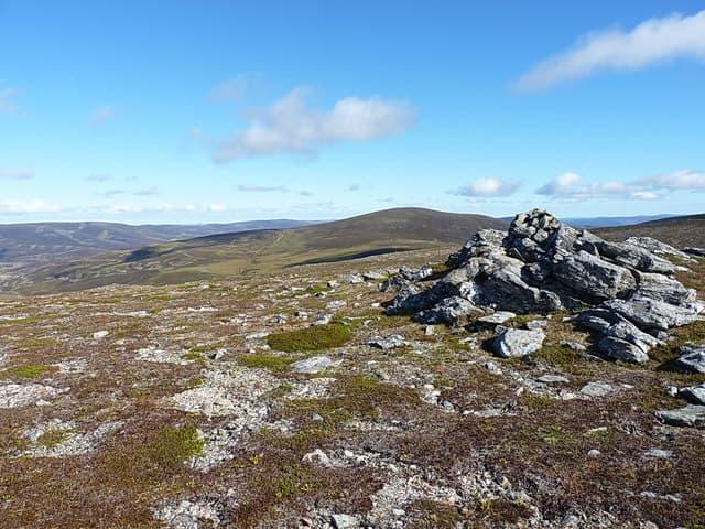
Creag an Dail Bheag is a quiet 863m Corbett in the rolling deer country between Ben Avon and the headwaters of the River Don — eastern Cairngorms fringe, north of Braemar. It is a hill of broad heather slopes and small granite outcrops rather than dramatic features, with the highest point a rock beside a small cairn on the southern edge of a wide plateau. The view westward into the heart of the Ben Avon massif is the day's real reward.
Gaelic: “crag, the, small” · Pronunciation: krayg an dail vek
Quick facts
- Height
- 863m/ 2831ft
- Prominence
- 211 m
- Distance
- 15 km
- Ascent
- 759 m
- Time
- 5–7 hrs
- Grid ref
- NO157981
- Parking
- NJ257093
- Nearest city
- Inverness· 68km
- Dogs
- Dogs on lead required near livestockDog-friendly guide ↗
Height and prominence cross-checked against the Database of British and Irish Hills (CC BY).
No GPX track yet
Walked this route? Share your track to help other walkers.
Standard route
estate track 40% · open heather 30% · plateau top 20% · summit edge 10%
Standard approach is via the estate track from the A939 at Cock Bridge / Corgarff, working in past Inchrory at the head of the Avon. From the bridge, leave the track and climb pathless heather and grass slopes south-west onto the broad plateau. The round comes in at about 15km and 759m of climb. Many baggers pair this hill with neighbouring Carn Liath for an eastern Cairngorms double — long but with no technical difficulty.
Terrain
The Inchrory estate tracks are well-graded and bike-friendly. Off the track the ground is short heather with patches of peat hag — slow but never seriously boggy. The summit plateau is broken granite blocks and heather; the small cairn sits on the southern edge above a low band of crag. Navigation on the featureless top is the main consideration.
In winter
A lower-altitude eastern Cairngorm Corbett where snow cover is reliable but rarely deep. Drifting on the plateau can fill in the few features and make finding the right edge difficult. No avalanche risk on the broad heather slopes. The Cock Bridge road is one of the first to close in heavy snowfall — the famous Lecht traffic message often applies here.
Best time of year
Getting there
- Glasgow3h 4m
- Edinburgh3h 39m
OS maps: OS Landranger 36, OS Landranger 43
Mobile signal: Zero signal in upper Glen Avon; intermittent at Cock Bridge
Current conditions
Daylight Today
- Sunrise
- 05:59
- Sunset
- 20:34
- Civil dawn
- 05:16
- Civil dusk
- 21:16
NOAA Solar Calculator · 24 August 2026
Around Creag an Dail Bheag on the SCOT network
Getting there, basing yourself, and what to do off the hill.
Getting there: Aviemore station
Cairngorm plateau; Lairig Ghru; Speyside Way; Glenmore
30km from the hill
tripscot.co.uk
On TripSCOTBase yourself in Ballater
Eastern Cairngorms / Royal Deeside
21km from the hill
tripscot.co.uk
On TasteSCOTAfter the hill: Royal Lochnagar
Balmoral — Queen Victoria's favourite; eastern Cairngorms setting
14km from the hill
tastescot.co.uk
Creag an Dail Bheag — common questions
- Is Creag an Dail Bheag a hard climb?
- Creag an Dail Bheag is rated 3/5 (moderately challenging) on the OutdoorSCOT scale. The standard route covers about 15km with 759m of ascent and takes most walkers 5-7 hours. Ground conditions: The Inchrory estate tracks are well-graded and bike-friendly.
- How much drop does Creag an Dail Bheag have?
- The drop is 211m: measured from the summit of Creag an Dail Bheag down to the saddle joining it to higher terrain.
- Where's the parking for Creag an Dail Bheag?
- Park at NJ257093. Double-check the grid reference on an OS map first; informal laybys here fill early in high season.
- What's the best month to climb Creag an Dail Bheag?
- Aim for May, June, July, August, September, October on Creag an Dail Bheag. In the remaining months treat it as a winter hill — full kit, solid navigation, and a look at the relevant SAIS avalanche forecast before you go.
- Can dogs go up Creag an Dail Bheag?
- Dogs are fine on a lead. The route passes livestock or ground-nesting bird habitat, so keep them close throughout.
- Will I get phone signal on Creag an Dail Bheag?
- Zero signal in upper Glen Avon; intermittent at Cock Bridge
- Is Creag an Dail Bheag safe in winter?
- A lower-altitude eastern Cairngorm Corbett where snow cover is reliable but rarely deep. Drifting on the plateau can fill in the few features and make finding the right edge difficult. No avalanche risk on the broad heather slopes. The Cock Bridge road is one of the first to close in heavy snowfall — the famous Lecht traffic message often applies here.
Get the OutdoorSCOT weekly
One email a week — new route, hill and bothy guides, seasonal conditions and the odd hard-won lesson. No spam, unsubscribe in one click.