Long distance
Formartine and Buchan Way
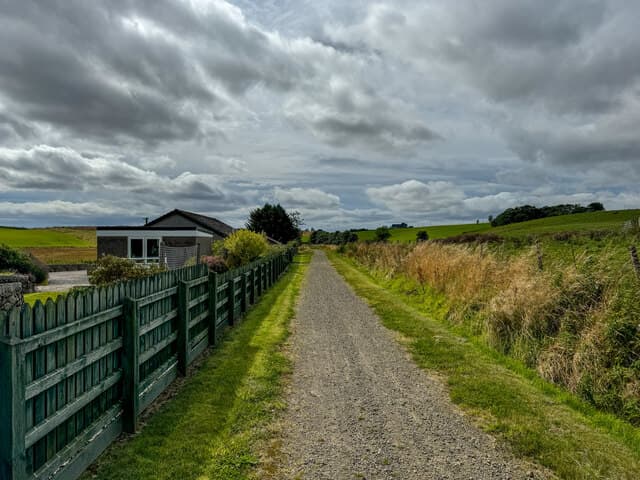
Follows a disused railway line from Aberdeen to Fraserburgh and Peterhead. Flat, easy and perfect for cycling as well as walking. The gentlest long-distance route in Scotland. Stretches 85 km (53 mi) and around 400 m of climbing; most parties take 3 days walking best south-to-north — a friendly short trail.
Quick facts
- Distance
- 85 km/ 53 mi
- Typical days
- 3
- Total ascent
- 400 m
- Difficulty
- easy
- Start → Finish
- Dyce (Aberdeen) → Fraserburgh / Peterhead
- Best direction
- South to North
- Water sources
- Dyce, Ellon, Maud, Strichen, Mintlaw, Fraserburgh, Peterhead — all have taps and shops. The disused railway trackbed crosses farmland with reliable streams. Treat before drinking. Cafes at the larger junctions add fill points.
- Mobile signal
- EE/Vodafone reliable along the populated Aberdeenshire corridor. The route is rarely far from a B-road, so coverage is generally continuous. Brief drops in the deeper forestry plantations.
✔ Waymarked throughout
Approximate profile derived from per-stage ascent — accurate on total climb and pattern, not a pixel-precise GPX trace.
Our take
The Formartine and Buchan Way is as flat as Scotland gets — a converted railway line with negligible ascent. It splits at Maud into branches to Fraserburgh and Peterhead. Useful as a gentle walking or cycling route through Aberdeenshire farming country, but lacks the scenery of coastal or highland routes. Best suited to beginners or as a cycling route.
Highlights
- Old Deer village and abbey ruins
- Aden Country Park
- Buchan countryside
- Fraserburgh harbour and lighthouse
Day-by-day itinerary
A suggested 3-day schedule. Adjust to your fitness and conditions.
1Dyce to Ellon28km · 150m ascent
Along the flat disused railway through Aberdeenshire farming country to the market town of Ellon on the River Ythan.
- Terrain
- Disused railway trackbed throughout. Flat and well-surfaced.
- Overnight
- Ellon has the Station Hotel and B&Bs. Good shops for resupply.
- Stats
- Dyce → Ellon · 28km · ↑150m
2Ellon to Maud25km · 100m ascent
Continue along the railway line through gentle Buchan farmland to the junction village of Maud, where the route splits to Fraserburgh and Peterhead.
- Terrain
- Disused railway trackbed. Flat throughout.
- Overnight
- Maud has limited B&Bs. Mintlaw is 3km away with the Saplinbrae Hotel.
- Stats
- Ellon → Maud · 25km · ↑100m
3Maud to Fraserburgh32km · 150m ascent
The northern branch follows the railway to Fraserburgh, Scotland's main shellfish port. The Museum of Scottish Lighthouses at Kinnaird Head is the finish highlight.
- Terrain
- Disused railway trackbed, approaching town on paths. Flat.
- Overnight
- Fraserburgh has hotels and B&Bs. The harbour area has good seafood restaurants.
- Stats
- Maud → Fraserburgh · 32km · ↑150m
Transport
To start (Dyce (Aberdeen))
Train · ScotRail
Dyce station (Aberdeen–Inverness line) directly at the trailhead
Check times & book →
From finish (Fraserburgh / Peterhead)
Bus · Stagecoach Bluebird
Frequent services from Fraserburgh and Peterhead back to Aberdeen
Check times & book →
Best months
Accommodation
B&Bs at Ellon, Maud and the finish towns. Limited in the middle section — plan stages carefully. B&Bs at Ellon, Mintlaw (near Maud) and Fraserburgh/Peterhead at the ends; Booking.com covers most. Limited mid-route options mean planning daily mileage carefully.
Night-by-night guide: where to stay →Resupply
Shops at Dyce, Ellon, Maud, Mintlaw, Fraserburgh and Peterhead. No genuinely remote sections. Co-op and Tesco in Dyce, Ellon, Mintlaw, Fraserburgh and Peterhead; longest gap is around 15km between Ellon and Maud and easily covered on a bike or on foot.
Current conditions
Weather at the start point (Dyce (Aberdeen))
Daylight Today
- Sunrise
- 05:02
- Sunset
- 21:28
- Civil dawn
- 04:09
- Civil dusk
- 22:21
NOAA Solar Calculator · 30 July 2026
Share your experience
Walked the Formartine and Buchan Way? Help others plan their trip.
Getting to and from the Formartine and Buchan Way
Train and town anchors at each end of the route — on TripSCOT.