Marilyn · Borders
Ward Law
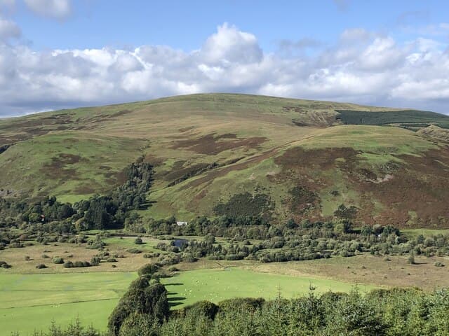
A 594m summit overlooking the Megget Water amid the Ettrick Forest hills. Despite its modest height, the position gives wide views across St Mary's Loch and toward the Manor Hills.
Quick facts
- Height
- 594m/ 1949ft
- Prominence
- 158 m
- Grid ref
- NT 26236 15950
- Parking
- NT 23000 23000
- Nearest city
- Dumfries· 49km
- Dogs
- Dogs on lead required near livestockDog-friendly guide ↗
Height and prominence cross-checked against the Database of British and Irish Hills (CC BY).
No GPX track yet
Walked this route? Share your track to help other walkers.
Standard route
grass moorland 65% · heather 25% · boggy ground 10%
Walkers usually start from the road by Megget Reservoir, climbing pathless grassy slopes for a 2-3 hour out-and-back. The route can be combined with neighbouring Cape Law for a longer day.
Terrain
Cropped sheep-grazed grass on the lower flanks, with peat hags and tussocks near the broad summit ridge. Mostly dry going.
In winter
Snow accumulates in the gullies above the reservoir and can persist into March. The broad summit needs careful navigation in mist.
Best time of year
Getting there
- Glasgow3h 0m
- Edinburgh1h 20m
OS maps: OS Landranger 79, OS Explorer 330
Mobile signal: Good. Scottish Borders; good EE coverage throughout the walk.
Current conditions
Daylight Today
- Sunrise
- 05:15
- Sunset
- 21:23
- Civil dawn
- 04:27
- Civil dusk
- 22:11
NOAA Solar Calculator · 30 July 2026
Around Ward Law on the SCOT network
Getting there, basing yourself, and what to do off the hill.
Ward Law — common questions
- Is Ward Law a hard climb?
- Ward Law is rated 2/5 (moderate) on the OutdoorSCOT scale. Terrain: Cropped sheep-grazed grass on the lower flanks, with peat hags and tussocks near the broad summit ridge.
- How prominent is Ward Law?
- Ward Law has 158m of topographic prominence — the height of its summit above the highest col connecting it to higher ground. Marilyns are defined by that measure: at least 150m of drop on all sides.
- Where should I park to climb Ward Law?
- Standard parking is at NT 23000 23000. Check the parking grid reference on an OS map before travel; informal laybys can fill on summer weekends.
- When should I climb Ward Law?
- The standard good-weather months for Ward Law are March, April, May, June, July, August, September, October, November. Outside those months, expect winter conditions on the high ground — full mountain kit, navigation skills, and a check of the SAIS avalanche forecast for the relevant region.
- Can I bring my dog up Ward Law?
- On a lead only — the route crosses ground with livestock or nesting-bird interest.
- What's mobile reception like on Ward Law?
- Good. Scottish Borders; good EE coverage throughout the walk.
- Is Ward Law safe in winter?
- Snow accumulates in the gullies above the reservoir and can persist into March. The broad summit needs careful navigation in mist.
Get the OutdoorSCOT weekly
One email a week — new route, hill and bothy guides, seasonal conditions and the odd hard-won lesson. No spam, unsubscribe in one click.