Marilyn · Orkney & Shetland
Ward Hill
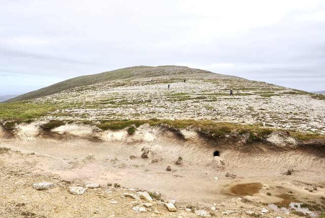
Ward Hill on Hoy is the highest point in Orkney, a great whaleback of Old Red Sandstone rising 481m above the western edge of the islands. From the summit the view stretches from Cape Wrath to the cliffs of St John's Head and across the Pentland Firth to Caithness.
Quick facts
- Height
- 481m/ 1578ft
- Prominence
- 481 m
- Grid ref
- HY 22863 02238
- Dogs
- Dogs on lead required near livestockDog-friendly guide ↗
Height and prominence cross-checked against the Database of British and Irish Hills (CC BY).
No GPX track yet
Walked this route? Share your track to help other walkers.
Standard route
heather moorland 50% · rough grassland 35% · Old Red Sandstone 15%
Most parties start from Rackwick or from the road end at Sandy Loch above Moaness, climbing through heather and bilberry onto the broad north-east ridge. The walk often pairs with the path to the Old Man of Hoy for a memorable day.
Terrain
Heather, crowberry and sandstone scree, with sections of bare red rock near the summit. Drier and firmer underfoot than the Shetland hills but the upper slopes are steep enough to need care.
In winter
Hoy holds snow more often than the rest of Orkney, and ice on the summit scree is the main winter hazard. The Stromness-to-Moaness ferry runs year round but is exposed to Scapa Flow gales.
Kit for this: the winter Munro kit list · which boots take crampons
Best time of year
Getting there
- Glasgow8h 13m
- Edinburgh8h 39m
Ferry access
Scrabster → Stromness (Orkney)
- Crossing time90 min
- Summer sailings3 sailings daily (Apr–Oct)
- Winter sailings2 sailings daily (Nov–Mar)
- Book ahead7 days
- Last ferry backCheck NorthLink timetable — last sailing back varies seasonally
Alternative: Pentland Ferries from Gills Bay → St Margaret's Hope (1h, more frequent) or Aberdeen → Kirkwall overnight. Hoy hills are a further short inter-island ferry hop from Stromness.
Book on ferry operator ↗OS maps: OS Landranger 6, OS Landranger 7, OS Explorer 462
Mobile signal: Moderate. EE on Hoy is patchy; better on the Stromness side.
Current conditions
Daylight Today
- Sunrise
- 07:08
- Sunset
- 19:01
- Civil dawn
- 06:28
- Civil dusk
- 19:41
NOAA Solar Calculator · 27 September 2026
Around Ward Hill on the SCOT network
Getting there, basing yourself, and what to do off the hill.
Ward Hill — common questions
- How difficult is Ward Hill?
- Ward Hill carries a 1/5 (easy) grade on the OutdoorSCOT scale. Ground conditions: Heather, crowberry and sandstone scree, with sections of bare red rock near the summit.
- How much drop does Ward Hill have?
- Ward Hill's prominence is its full height — 481m — because it is the highest point of its landmass, with no higher ground connected to it. Passing the 150m-drop threshold on all sides is exactly what makes it a Marilyn.
- What's the best month to climb Ward Hill?
- Aim for March, April, May, June, July, August, September, October on Ward Hill. In the remaining months treat it as a winter hill — full kit, solid navigation, and a look at the relevant SAIS avalanche forecast before you go.
- Can dogs go up Ward Hill?
- Dogs are fine on a lead. The route passes livestock or ground-nesting bird habitat, so keep them close throughout.
- Will I get phone signal on Ward Hill?
- Moderate. EE on Hoy is patchy; better on the Stromness side.
- How do I get the ferry to Ward Hill?
- Scrabster → Stromness (Orkney). 3 sailings daily (Apr–Oct) in summer; 2 sailings daily (Nov–Mar) in winter. Book at least 7 days ahead. Alternative: Pentland Ferries from Gills Bay → St Margaret's Hope (1h, more frequent) or Aberdeen → Kirkwall overnight. Hoy hills are a further short inter-island ferry hop from Stromness.
- Is Ward Hill safe in winter?
- Hoy holds snow more often than the rest of Orkney, and ice on the summit scree is the main winter hazard. The Stromness-to-Moaness ferry runs year round but is exposed to Scapa Flow gales.
Get the OutdoorSCOT weekly
One email a week — new route, hill and bothy guides, seasonal conditions and the odd hard-won lesson. No spam, unsubscribe in one click.