Marilyn · Orkney & Shetland
Ward Hill
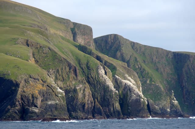
Ward Hill is the high point of Fair Isle, the famously isolated bird island halfway between Shetland and Orkney. At 220m it forms the northern half of the three-mile-long island and looks down on the bird observatory, the croftland and the great seabird cliffs of Sheep Rock.
Quick facts
- Height
- 220m/ 722ft
- Prominence
- 220 m
- Grid ref
- HZ 20862 73379
- Dogs
- Dogs on lead required near livestockDog-friendly guide ↗
Height and prominence cross-checked against the Database of British and Irish Hills (CC BY).
No GPX track yet
Walked this route? Share your track to help other walkers.
Standard route
heather moorland 55% · rocky slopes 30% · grass slopes 15%
A short pull from the road near the airstrip onto grazed hillside, then over a heather plateau to the trig point. There are no constructed paths but the island is small enough that the route is straightforward in clear weather.
Terrain
Short sheep-cropped turf and shallow peat, with patches of bare gravel near the summit and a fenceline that gives a handrail in mist. Stay clear of the cliff edges and respect bird colonies in nesting season.
In winter
Fair Isle is wide open to Atlantic and North Sea systems; ferry and flight access often pauses for days in winter storms. Snow is unusual but salt spray reaches the summit in strong winds.
Best time of year
Getting there
- Glasgow12h 42m
- Edinburgh10h 8m
OS maps: OS Landranger 4, OS Explorer 466S
Mobile signal: Poor. Fair Isle is remote; only patchy coverage near the south of the island.
Current conditions
Daylight Today
- Sunrise
- 06:32
- Sunset
- 19:33
- Civil dawn
- 05:50
- Civil dusk
- 20:15
NOAA Solar Calculator · 14 September 2026
Ward Hill — common questions
- What difficulty is Ward Hill?
- On the OutdoorSCOT scale, Ward Hill comes in at 1/5 — easy. Terrain: Short sheep-cropped turf and shallow peat, with patches of bare gravel near the summit and a fenceline that gives a handrail in mist.
- How prominent is Ward Hill?
- Ward Hill's prominence is its full height — 220m — because it is the highest point of its landmass, with no higher ground connected to it. Marilyns are defined by that measure: at least 150m of drop on all sides.
- When should I climb Ward Hill?
- The standard good-weather months for Ward Hill are March, April, May, June, July, August, September, October. Outside those months, expect winter conditions on the high ground — full mountain kit, navigation skills, and a check of the SAIS avalanche forecast for the relevant region.
- Can I bring my dog up Ward Hill?
- On a lead only — the route crosses ground with livestock or nesting-bird interest.
- What's mobile reception like on Ward Hill?
- Poor. Fair Isle is remote; only patchy coverage near the south of the island.
- Is Ward Hill safe in winter?
- Fair Isle is wide open to Atlantic and North Sea systems; ferry and flight access often pauses for days in winter storms. Snow is unusual but salt spray reaches the summit in strong winds.
Get the OutdoorSCOT weekly
One email a week — new route, hill and bothy guides, seasonal conditions and the odd hard-won lesson. No spam, unsubscribe in one click.