Marilyn · Ochils
Craigowl Hill
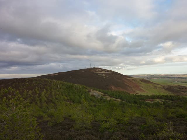
Craigowl Hill is the highest of the Sidlaws, its 455m summit and cluster of communication masts a landmark on the skyline north of Dundee at NO37. The pull from Balkello Community Woodland is the standard line.
Quick facts
- Height
- 455m/ 1493ft
- Prominence
- 393 m
- Grid ref
- NO 37697 39985
- Parking
- NO 376 402
- Nearest city
- Dundee· 10km
- Dogs
- Dogs on lead required near livestockDog-friendly guide ↗
Height and prominence cross-checked against the Database of British and Irish Hills (CC BY).
No GPX track yet
Walked this route? Share your track to help other walkers.
Standard route
heather moorland 50% · grass slopes 35% · rocky summit 15%
Walk up from the Balkello car park north of Tealing on the broad track past the woodland, then strike up the open hillside on the well-used path to the masts. Return via the same line or extend along the Sidlaw ridge to Auchterhouse Hill.
Terrain
Estate track for the first kilometre then short grass and heather to the summit plateau. The service road to the masts gives an obvious foul-weather line.
In winter
Modest height keeps Craigowl out of serious winter conditions, but the exposed plateau collects rime ice and bitter east winds straight off the North Sea. The mast track stays usable through most snowfall.
Best time of year
Getting there
- Glasgow4h 39m
- Edinburgh2h 36m
OS maps: OS Landranger 54, OS Explorer 380E
Mobile signal: Good. Dundee/Angus; EE reliable. Multiple masts on Sidlaw Hills.
Current conditions
Daylight Today
- Sunrise
- 05:09
- Sunset
- 21:28
- Civil dawn
- 04:18
- Civil dusk
- 22:19
NOAA Solar Calculator · 30 July 2026
Around Craigowl Hill on the SCOT network
Getting there, basing yourself, and what to do off the hill.
Craigowl Hill — common questions
- What difficulty is Craigowl Hill?
- On the OutdoorSCOT scale, Craigowl Hill comes in at 1/5 — easy. Terrain: Estate track for the first kilometre then short grass and heather to the summit plateau.
- How prominent is Craigowl Hill?
- Craigowl Hill has 393m of topographic prominence — the height of its summit above the highest col connecting it to higher ground. Marilyns are defined by that measure: at least 150m of drop on all sides.
- Where should I park to climb Craigowl Hill?
- Standard parking is at NO 376 402. Check the parking grid reference on an OS map before travel; informal laybys can fill on summer weekends.
- When should I climb Craigowl Hill?
- The standard good-weather months for Craigowl Hill are March, April, May, June, July, August, September, October. Outside those months, expect winter conditions on the high ground — full mountain kit, navigation skills, and a check of the SAIS avalanche forecast for the relevant region.
- Can I bring my dog up Craigowl Hill?
- On a lead only — the route crosses ground with livestock or nesting-bird interest.
- What's mobile reception like on Craigowl Hill?
- Good. Dundee/Angus; EE reliable. Multiple masts on Sidlaw Hills.
- Is Craigowl Hill safe in winter?
- Modest height keeps Craigowl out of serious winter conditions, but the exposed plateau collects rime ice and bitter east winds straight off the North Sea. The mast track stays usable through most snowfall.
Get the OutdoorSCOT weekly
One email a week — new route, hill and bothy guides, seasonal conditions and the odd hard-won lesson. No spam, unsubscribe in one click.