Graham · Outer Hebrides
Beinn Mhor
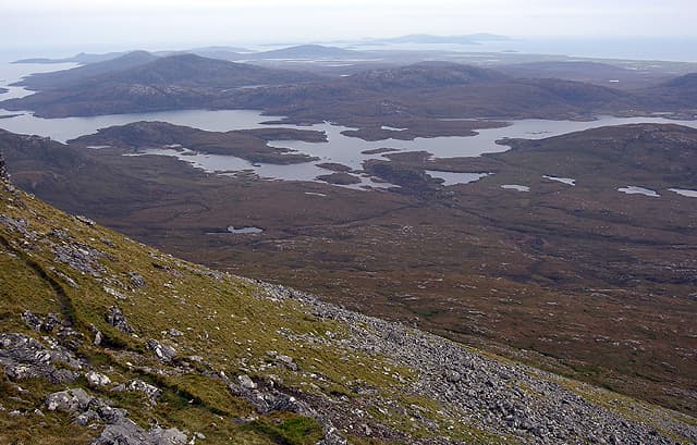
Beinn Mhor (620m) is the proud high point of South Uist in the NF80 square, a long gneiss spine running north-south above the loch-pitted Atlantic moor. The rock summit sits at the head of an exposed kilometre-long crest where the ridge narrows to little more than a sheep walk between rough cliffs. On clear days the view runs from St Kilda far out to the Cuillin of Skye.
Gaelic: “mountain, big” · Pronunciation: bine vore
Quick facts
- Height
- 620.5m/ 2036ft
- Prominence
- 621 m
- Distance
- 12 km
- Ascent
- 465 m
- Time
- 3–6 hrs
- Grid ref
- NF808311
- Nearest
- Fort William
- Dogs
- Dogs on lead required near livestockDog-friendly guide ↗
Height and prominence cross-checked against the Database of British and Irish Hills (CC BY).
No GPX track yet
Walked this route? Share your track to help other walkers.
Standard route
rocky ridge 40% · blanket bog 40% · heather moorland 20%
Park on the verge near the township at Loch Aineort and follow the burn east into the corrie below the south top. The pull onto Beinn Mhor itself is steep but on grass and short heather; the ridge above is a fine high-level walk to the small rock summit. Eight hours allows time for the ascent, the airy ridge and the return — there are no easy shortcuts off the crest.
Terrain
Boggy machair-fringe moor and lochan country fills the approach. The corrie wall climbs steeply on grass-and-rock terraces. The summit ridge is narrow with a notable cliff edge to the east — manageable in calm weather but committing in strong wind.
In winter
Snow seldom settles at the boggy lower altitudes but the gneiss summit ridge ices over swiftly under any cold spell. The greater risk is wind: the unbroken Atlantic fetch means gusts above 100 mph are not unusual. Short daylight and the long boggy approach make winter visits a serious undertaking.
Best time of year
Getting there
- Glasgow5h 40m
- Edinburgh6h 35m
Ferry access
Oban → Lochboisdale (South Uist)
- Crossing time225 min
- Summer sailings1 sailing daily plus additional weekend sailings (Apr–Oct)
- Winter sailings4–5 sailings per week (Nov–Mar)
- Book ahead14 days
Plan an overnight stay. Alternative: Uig (Skye) → Lochmaddy (North Uist) then drive south across the causeways.
Book on CalMac ↗OS maps: OS Landranger 22
Mobile signal: Poor. South Uist; signal is marginal here in this remote area.
Current conditions
Daylight Today
- Sunrise
- 04:52
- Sunset
- 22:18
- Civil dawn
- 03:50
- Civil dusk
- 23:20
NOAA Solar Calculator · 13 July 2026
Pair with
Curated multi-hill combinations from Beinn Mhor.
Beinn Mhor — common questions
- How difficult is Beinn Mhor?
- Beinn Mhor carries a 4/5 (challenging) grade on the OutdoorSCOT scale. Count on about 12km, 465m of ascent and a 3-6 hour day on the standard route. Underfoot: Boggy machair-fringe moor and lochan country fills the approach.
- What is Beinn Mhor's prominence?
- Beinn Mhor's prominence is its full height — 621m — because it is the highest point of its landmass, with no higher ground connected to it.
- When is the best time to climb Beinn Mhor?
- May, June, July, August, September give the most reliable conditions on Beinn Mhor. Beyond that window the high ground turns wintry: carry full mountain kit, be confident navigating, and check the SAIS avalanche forecast for the area.
- Is Beinn Mhor dog-friendly?
- Yes, but dogs must be kept on a lead — there is livestock or ground-nesting bird interest on the route.
- Is there mobile signal on Beinn Mhor?
- Poor. South Uist; signal is marginal here in this remote area.
- How do I get the ferry to Beinn Mhor?
- Oban → Lochboisdale (South Uist). 1 sailing daily plus additional weekend sailings (Apr–Oct) in summer; 4–5 sailings per week (Nov–Mar) in winter. Book at least 14 days ahead. Plan an overnight stay. Alternative: Uig (Skye) → Lochmaddy (North Uist) then drive south across the causeways.
- Is Beinn Mhor safe in winter?
- Snow seldom settles at the boggy lower altitudes but the gneiss summit ridge ices over swiftly under any cold spell. The greater risk is wind: the unbroken Atlantic fetch means gusts above 100 mph are not unusual. Short daylight and the long boggy approach make winter visits a serious undertaking.
Get the OutdoorSCOT weekly
One email a week — new route, hill and bothy guides, seasonal conditions and the odd hard-won lesson. No spam, unsubscribe in one click.